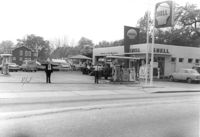
Shell gas station on site affected by the construction of Interstate 26 (I-26). Address: 1227 King Street. Surveyor notations on back of photo: "Dkt.: 10.503. Property owner: Shell Oil Co. Tract: 14-A. Station: 9+50 Rt. (Mt. Pleasant St.). Date: Apr. 20, 1965." [See collection description for explanation of surveyor notations.]
Shell gas station on site affected by the construction of Interstate 26 (I-26). Address: 1227 King Street. Surveyor notations on back of photo: "Dkt.: 10.503. Property owner: Shell Oil Co. Tract: 14-A. Station: 9+50 Rt. (Mt. Pleasant St.). Date: Apr. 20, 1965." [See collection description for explanation of surveyor notations.]
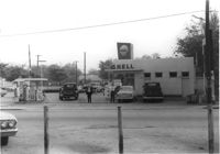
Esso Service Station: at intersection of Orange Grove Road and SC Highway 7 (Sam Rittenberg Boulevard), on site affected by the widening of Routes 7 & 171. Surveyor notations on back of photo: "Dkt.: 10.551. Property owner: Humble Oil Co. Tract: 1. Station: 36±00 Rt. Date: Jul. 22, 1965. West from east side Orange Grove Rd. of range poles on corners of ? area. [See collection description for explanation of surveyor notations.]
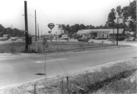
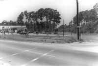
Esso Service Station: at intersection of Orange Grove Road and SC Highway 7 (Sam Rittenberg), on site affected by the widening of Routes 7 & 171. Surveyor notations on back of photo: "Dkt.: 10.551. Property owner: Humble Oil Co. Tract: 1. Station: 36±00 Rt. Date: Jul. 22, 1965. Taken from intersection of Orange Grove Rd. and Rte. 7 & 171. [See collection description for explanation of surveyor notations.]
Limit your search
SCDOT Photographs: Properties in the Right-of-Way✖[remove]4
Right of way--South Carolina--Charleston County, Highway planning--South Carolina--Charleston County, Commercial buildings--South Carolina--Charleston County, Service stations--South Carolina--Charleston County, Vernacular architecture--South Carolina--Charleston County, Lost architecture--South Carolina--Charleston County✖[remove]4