Search Home
Search in
search for
Simple Search
Page Content Search
Title Search
Creator Search
Subject Search
Search
search icon
Search
Search Constraints
Start Over
You searched for:
Media Type
Maps
✖
Remove constraint Media Type: Maps
Subject (Geographic)
Ashepoo River (S.C.)
✖
Remove constraint Subject (Geographic): Ashepoo River (S.C.)
1
-
7
of
7
Sort
by Relevance
Relevance
Title
Date (Newest)
Date (Oldest)
Number of results to display per page
10
per page
10
per page
20
per page
50
per page
100
per page
View results as:
list icon
List
masonry icon
Masonry
Search Results
Ashepoo River Plat 1732
Plat in St. Bartholomew's Parish 1732
Horseshoe Creek Plat 1734
Plat in Colleton County 1735
St. Bartholomew's Parish Plat 1753
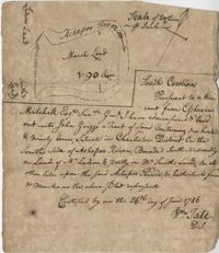
Ashepoo River Plat 1786
Plat on the Ashepoo River 1793
Limit your search
Collection
John McCrady Plats and Deeds Collection
7
Contributing Institution
South Carolina Historical Society
7
Media Type
Maps
✖
[remove]
7
Subject (Topic)
Maps
7
Surveying--South Carolina
7
Conveyancing--South Carolina
7
Subject (Geographic)
Ashepoo River (S.C.)
✖
[remove]
7
Charleston District (S.C.)
1
Date
1732
2
1734
1
1735
1
1753-06-15
1
1786-06-26
1
1793
1
Date Range (beta)
View distribution
Current results range from
1732
to
1793
Date Range (beta) range begin
Date Range (beta) range end
View larger »