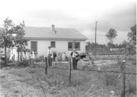
Backyard lot on site affected by the construction of Interstate 26 (I-26). House (corner view, rear) in background. Surveyor notations on back of photo: "Dkt.: 10.480. Property owner: Jennie B. Henson, et al. Tract: 73. Station: 5517+20 Rt. Date: May 2, 1961. Proximity." [See collection description for explanation of surveyor notations.]
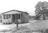
House in dilapidated condition on site affected by the construction of Interstate 26 (I-26). Outbuilding/shed in background. Surveyor notations on back of photo: "Dkt.: 10.480. Property owner: Laurence Pinckney, et al. Tract: 74. Station: 5520+80 Lt. Date: May 2, 1961. In R/W - Bought." [See collection description for explanation of surveyor notations.]
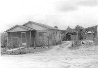
House on site affected by the construction of Interstate 26 (I-26). Driveway leads to garage/shed. Rooster and peacock in lot next door. Surveyor notations on back of photo: "Dkt.: 10.480. Property owner: Sadie B. Jones Franklin. Tract: 79. Station: 5519+40 Rt. Date: May 2, 1961. In R/W - Bought." [See collection description for explanation of surveyor notations.]
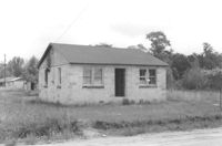
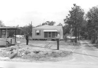
House on site affected by the construction of Interstate 26 (I-26). Surveyor notations on back of photo: "Dkt.: 10.480. Property owner: Evelyn Nelson. Tract: 80. Station: 5519+30 Rt. Date: May 2, 1961. In R/W - Bought." [See collection description for explanation of surveyor notations.]
House on site affected by the construction of Interstate 26 (I-26). Outbuilding in background. Surveyor notations on back of photo: "Dkt.: 10.480. Property owner: Rosa Bell Harley. Tract: 83. Station: 5521+80 Rt. Date: May 2, 1961. In R/W - Bought." [See collection description for explanation of surveyor notations.]
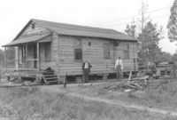
House on site affected by the construction of Interstate 26 (I-26). Outbuilding in background; lumber and other debris in yard. Surveyor notations on back of photo: "Dkt.: 10.480. Property owner: Sylvia Yaschik. Tract: 94. Station: 5523+60 Rt. Date: May 2, 1961. In R/W - Bought." [See collection description for explanation of surveyor notations.]
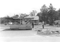
Lot with what appears to be a roadside stand; house in background, on site affected by the construction of Interstate 26 (I-26). Surveyor notations on back of photo: "Dkt.: 10.480. Property owner: Marshall A. Radford, et al. Tract: 101. Station: 60+20 Lt. (Goodrich Road). Date: May 2, 1961. In R/W - Bought." [See collection description for explanation of surveyor notations.]
Lot with what appears to be a roadside stand; house in background, on site affected by the construction of Interstate 26 (I-26). Surveyor notations on back of photo: "Dkt.: 10.480. Property owner: Marshall A. Radford, et al. Tract: 101. Station: 60+20 Lt. (Goodrich Road). Date: May 2, 1961. Proximity." [See collection description for explanation of surveyor notations.]
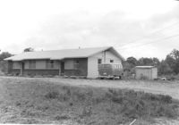
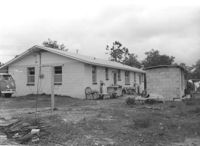
House, possibly duplex, on site affected by the construction of Interstate 26 (I-26). Surveyor notations on back of photo: "Dkt.: 10.480. Property owner: Roy A. Farley, et al. Tract: 102-A. Station: 55+60 Lt. (Goodrich Road). Date: May 2, 1961. Proximity." [See collection description for explanation of surveyor notations.]
House, possibly duplex (side view, rear), and outbuilding, on site affected by the construction of Interstate 26 (I-26). Surveyor notations on back of photo: "Dkt.: 10.480. Property owner: Roy A. Farley, et al. Tract: 102-A. Station: 55+60 Lt. (Goodrich Road). Date: May 2, 1961. Proximity." [See collection description for explanation of surveyor notations.]