Search Home
Search in
search for
Simple Search
Page Content Search
Title Search
Creator Search
Subject Search
Search
search icon
Search
Search Constraints
Start Over
You searched for:
Media Type
Maps
✖
Remove constraint Media Type: Maps
Subject (Geographic)
Saint Paul’s Parish (Charleston County, S.C.)
✖
Remove constraint Subject (Geographic): Saint Paul’s Parish (Charleston County, S.C.)
Date Range (beta)
1740
to
1759
✖
Remove constraint Date Range (beta): <span class="from" data-blrl-begin="1740">1740</span> to <span class="to" data-blrl-end="1759">1759</span>
1
entry found
Sort
by Relevance
Relevance
Title
Date (Newest)
Date (Oldest)
Number of results to display per page
10
per page
10
per page
20
per page
50
per page
100
per page
View results as:
list icon
List
masonry icon
Masonry
Search Results
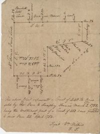
St. Paul's Parish Plat
Limit your search
Collection
John McCrady Plats and Deeds Collection
1
Contributing Institution
South Carolina Historical Society
1
Media Type
Maps
✖
[remove]
1
Subject (Topic)
Conveyancing--South Carolina, Maps, Surveying--South Carolina
1
Subject (Geographic)
Saint Paul’s Parish (Charleston County, S.C.)
✖
[remove]
1
Date
1752
1
Date Range (beta)
1740
to
1759
✖
[remove]
1
1740
to
1741
0
1742
to
1743
0
1744
to
1745
0
1746
to
1747
0
1748
to
1749
0
1750
to
1751
0
1752
to
1753
1
1754
to
1755
0
1756
to
1757
0
1758
to
1759
0
Current results range from
1752
to
1752
Date Range (beta) range begin
Date Range (beta) range end
View larger »