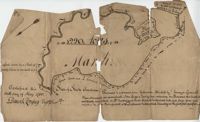
BACK: John Griggs 1220 acres Charleston 1 June 1786 [?] Peter Freneau. FRONT: “Pursuant to a warrant from Ephraim Mitchell Esquire Surveyor General and laid out unto John Griggs a Tract of land containing one thousand two hundred and twenty acres (1220) situated in St. Bartholomew's Parish Charleston District and has such shape form and marks as the above plat represents. Likewise butting and bounding as the said plat specifies." Names associated with this plat are John Griggs, Ephraim Mitchell, Daniel Doyley, Edmund Belling, Gochran, Gabriel Stock, Gochnan [?], and Peter Freneau [?]. Notable geographic locations include the Ch[?]aw River, Charleston District and St. Bartholomew's Parish.