Page 58 of the City Engineer's Plat Book with six plats. Plat 1 shows lots between Broad Street and Short Street, near their intersections with Mazyck Street. Plat 2 features lots on Greenhill Street, Limehouse Street, and Tradd Street. Plat 2 also shows a line labelled "Edge of High Land." Plat 3 shows lots near Broad Street, including lots labelled "Hawens Square" and "Burying Ground." Plat 3 also shows structures labelled "Magazine" and "Work House." Plat 4 shows lots located on King Street. Plat 5 shows land located between Meeting Street and Lee Street, and a dotted line labelled "City Boundary." Plat 6 shows lots located between President Street and Norman Street.
1770-1779, 1760-1769, 1740-1749, 1750-1759, 1720-1729, and 1730-1739
Description:
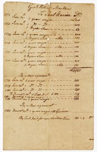
The Ball Family Account and Blanket Book, 1720-1778, includes lists of purchases, expenses, blankets given out to enslaved persons, and names/ages of enslaved persons at Midway, Limerick, Comingtee and Kensington Plantations. The book includes a loose list of enslaved men with their place of birth and ages, ca. 1750, currently on exhibit at the South Carolina Historical Society Museum.
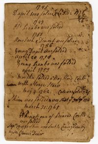
The Foaling Register, 1745-1777, is a bound register kept by Elias Ball II recording the selling and purchasing of horses, mules and mares and the births of colts at Kensington and Limerick Plantations.
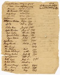
A list of enslaved children born between 1758-1817. Information includes the name of the enslaved child, their date of birth and occasionally, the name of their mother and father.
True copy of Peter Sinkler plat contains 310 acres in Craven County [now in parts of Berkeley, Charleston, Georgetown, and Williamsburg counties] bounding northwest on land of Isaac Porcher and Rene Pyre, southeast on land of Robert Taylor and Rene Ravenel, and northwest on Santee River. Names associated with this plat are Peter Sinkler, Robert Taylor, Ephraim Mitchell, Rene Pyre, Isaac Porcher, Rene Ravenel, John Brernon, and Henry Mowlon. Notable geographic locations include St. James Parish, the Santee River and Craven County.
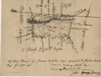
Plan of a tract of 1000 acres of land in Wall Eye Swamp in Craven County [now in parts of Berkeley, Charleston, Georgetown, and Williamsburg counties]. Names associated with this plat are Samuel Cooper, James Sinkler, Peter Sinkler, Isham Moore, John Bremar, and William Bull.
Plat of 4883 acres belonging to Thomas Smith. Very little detail, only the outline of the property is included. Names associated with this plat are Thomas Smith, General Oglethorpe, Smith, Thomas Elliott, Hugh Bryan, and Allen. Notable geographic locations include Granville.
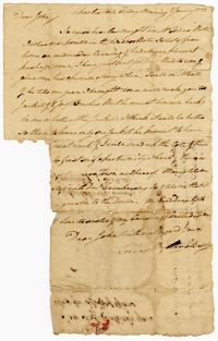
A letter written by Elias Ball II to his brother John Ball at Kensington Plantation discussing travel, jackets and hiring a doctor for a medical opinion.
The Fairfield Plantation Book, 1775-1794, is a clothing and blanketing book containing the names of enslaved persons (1773), children born at the plantation (1775), a list of clothes, blankets and tools given out to enslaved persons (1773-1775), cattle and hog inventory, lists of births and deaths of enslaved persons (1792-1797), and lists of enslaved families at Fairfield and Wappoo Plantations (1773-1797). The book contains a second use written back to front and upside down.