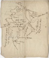
4000 acre plot of land for James Peach with its natural boundaries being rivers instead of property lines, also shows surrounding properties and their names. Names associated with this plat are James Peach, Lowright and Ellis Barce. Notable geographic locations include New River, Wrights River, Daufuskie Island, New River, Wright’s River, The North River, Cuningham Point, Savannah River, Black Oyster Bank, Turrapin Beech, Pine Island Creek, Red Bluff, and Townbridge Landing.
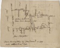
Plat of 1000 acres on the Scull Creek belonging to John Luck. Details include the areas of the creek and minimal buildings. Names associated with this plat are John Luck and J.B. Gerardeau. Notable geographic locations include Hilton Head Island, Cotton Hope Plantation, Fairlawn, St. Luke's Parish and Scull Creek.
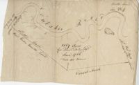
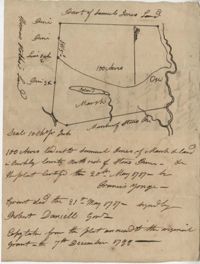
Plat of land along the Combahee River containing 5567 acres laid out for Daniel Doiley. Names associated with this plat are Daniel Doiley, Smith, Gordon Garrett, and Philips. Notable geographic locations include the Combahee River, Prince William's Parish and Tarr Bluff.
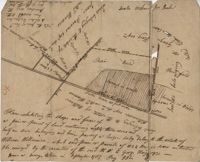
83 acre parcel of land that shows the land belonging to the estate of William Williamson, shows rice fields, swamp in woods, public drains, and roads. Names associated with this plat are William Williamson, George Haigery, and James Parsons. Notable geographic locations include the Stono River and Wenners.
"Copy of a plat of a tract now belonging to Richard Goughlr." The tract contains 500 acres and states that it was granted to Isaac Lewis on March 21, 1715. Names associated with this plat are Isaac Lewis, John Broughton, John Glover, John Diamond, and Richard Goughlr [?]. Notable geographic locations include Goose Creek, St. James Parish and Black Jon Bay.
Tract of land includes 224 acres. Plat includes house and cemetery as well as a path and road. Names associated with this plat are William Harvey, William Charles, Thomas Elliott, William Harvey, Charles Linning, and Charles Elliott. Notable geographic locations include St. Andrews Parish and Wappoo Creek.
876 acres of land west of Murray Road in St. John's Parish. Names associated with this plat are Chas Johnston, Ben Castell, William Simpson, Verth, and J.G. Wiare. Notable geographic locations include Wadboo Barony.
Plat of approximately 300 acres of marsh and farm land on the Stono River. Marsh and high land are denoted on the plat with few other details. Names associated with this plat are Mansfield, Mathuvin [?] Guevin, Franics [?] Guevin, Rebecca Chapman, Francis Wilkinson, Gaspar Trotti, and Stephen Ravenel. Notable geographic locations are the Stono River.
Plat of land of 64 acres laid out for Allard Belin situated on Sandy Island. Names associated with this plat are Allard Berlin, John Hardwick and D.T. Waring.
Limit your search
John McCrady Plats and Deeds Collection✖[remove]246