Page 254 of the City Engineer's Plat Book with one plat. A "Plat of Wagner Terrace," showing numerous lots and Hampton Park. Streets shown include Dunneman Street, Grove Street, and Rutledge Avenue.
Page 111 of the City Engineer's Plat Book with one plat. This plat shows lots located near the intersection of East Bay Street and Broad Street. It also shows a building labelled "EXCHANGE," and Gillon Street.
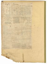
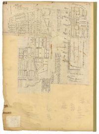
Page 126 of the City Engineer's Plat Book with three plats. Plat 1 shows lots and structures located between George Street and Boundary Street, and between Meeting Street and Scarborough Street. Plat 2 shows lots on Anson Street, with one building labelled "Palmetto Engine House." Plat 3 shows a large swathe of land, including marshes and streams. One stream is labelled "Vardells CK," and a line towards the right of the plat is labelled "North Eastern Rail Road." The streets on this plat include King Street, Hampton Street, Moultrie Street, Meeting Street, America Street, Bay Street, Stewart Street, Cooper Street, and Line Street.
Page 193 of the City Engineer's Plat Book with one plat. The plat shows lots located between Congress Street and Fishburne Street, and from Rutledge Street to past President Street. The plat also shows Payne Street.
Page 44 of the City Engineer's Plat Book with two plats. Plat 1 shows land between Meeting Street and a stretch of Marsh, and shows a stretch of railroad. Plat 1 also shows "Nassaw Street," Hanover Street, America Street, William Street, Isabella Street, "Rumney Street," Center Street, and "Cool-Blow Street." Plat 2 shows plats on "Rumney Street," between King Street and Meeting Street, including the intersection with Russell Street.
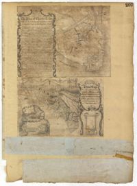
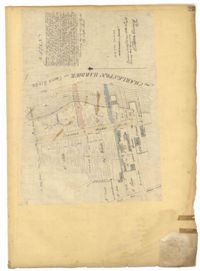
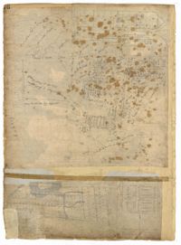
Page 203 of the City Engineer's Plat Book with one plat. An illustrated title card reads "A Plan of Charles Towne Copied with a Pen from an Old Dilapidated Plat without a Date," and depicts a harbor scene with Europeans and enslaved people. The plat labels landmarks and streets using capital and lowercase letters. These locations include Broad Street, the "State House," several churches, Boundary Street, the Exchange, an armory, and a beef market.
Page 214 of the City Engineer's Plat Book with two plats. Plat 1 shows lots located between Savage Street and Chisolm Street, and between Broad Street and Tradd Street. Plat 1 also shows Rutledge Avenue. Plat 2 shows a similar area to Plat 1, but also includes New Street, Franklin Street, Trapman Street, and Lynch Street.
Page 70 of the City Engineer's Plat Book with two plats. Plat 1 shows lots located near the intersection of "Broad Road" and George Street, with several buildings and bodies of water. Plat 2 shows a mill pond, marshlands, and structures located near the Ashley River.
Page 58 of the City Engineer's Plat Book with six plats. Plat 1 shows lots between Broad Street and Short Street, near their intersections with Mazyck Street. Plat 2 features lots on Greenhill Street, Limehouse Street, and Tradd Street. Plat 2 also shows a line labelled "Edge of High Land." Plat 3 shows lots near Broad Street, including lots labelled "Hawens Square" and "Burying Ground." Plat 3 also shows structures labelled "Magazine" and "Work House." Plat 4 shows lots located on King Street. Plat 5 shows land located between Meeting Street and Lee Street, and a dotted line labelled "City Boundary." Plat 6 shows lots located between President Street and Norman Street.
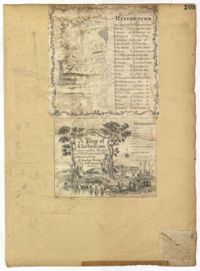
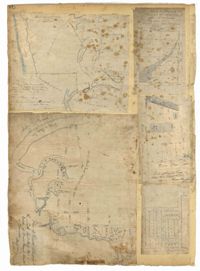
Page 207 of the City Engineer's Plat Book with two plats. Plat 1 is titled "The Plan of Charles Town With its Entrenchments and those made during the Siege by the English 1780," and shows Queen Street, Church Street, Tradd Street, King Street, Broad Street, the State House, the Market, the Arsenal, an "Old Church" and a "New Church." It also shows certain geographic features, including "Cummins Point," Cannons Point, and Hampstead Hill. Plat 2 has a label reading "This Map In every particular copied with a Pen from an Old Plat of Charles Town dated 1671 found in a Book of Plats of various parts of U.S.A. printed in London 1671." Plat 2 shows several geographic features such as rivers and islands, and features numerous illustrations. The largest illustration depicts two groups of people interacting from either side of a stream. Each group holds a single spear.
Page 14 of the City Engineer's Plat Book with one plat. The plat shows land between Bay Street and Church Street, including stretches of Tradd Street, Broad Street, and Queen Street.
Page 12 of the City Engineer's Plat Book with two plats. Plat 1 shows plots near Coming Street, St. Phillip Street, King Street, Meeting Street, and Vanderhorst Street. Plat 2 Shows lots on Queen Street near the intersections with East Bay Street and Prioleau Street, has the label "Charleston Harbour Cooper River" on the right-hand margin.
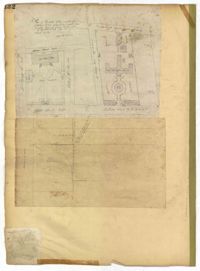
Page 132 of the City Engineer's Plat Book with two plats. Plat 1 features a plan for the College of Charleston, showing buildings labelled "Charleston College," "Library," "Lodge," and "Charleston Orphan House." Streets on this plat include George Street, Smith Street, College Street, Calhoun Street, St. Philips Street, and Vanderhorst Street. Plat 2 shows lots located near the intersection of Montague Street and Lynch Street.
Page 23 of the City Engineer's Plat Book with one plat. The plat shows lots, buildings, shoals, and mud flats located near the Charleston Harbor on the Cooper River, Concord Street, Pinckney Street, and East Bay Street.
Page 101 of the City Engineer's Plat Book with two plats. Plat 1 shows lots located between Washington Street and Wharf Street, and between Calhoun Street and Laurens Street. Plat 2 shows lots located near the intersection of Rutledge Avenue and Line Street, with several buildings labelled.
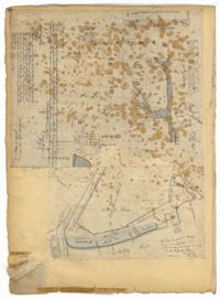
Page 78 of the City Engineer's Plat Book with five plats. Plat 1 features land and lots located near the Ashley River, including geographic features such as marshland, high land, and bodies of water. Plat 1 also shows Boundary Street, Hutson Street, Doughty Street, Bee Street, Elliot Street, Cannon Street, President Street, and Thomas Street. Plat 2 shows a city block between Doughty Street and Bee Street, and between President Street and Thomas Street, with some marsh labelled. Plat 3 features land and lots located near the Ashley River, with shoals and streams labelled. Plat 3 also shows Boundary Street, Pinckney Street, Cannon Street, Hutson Street, Doughty Street, and Bee Street. Plat 4 shows lots located near the intersection of Calhoun Street and Lucas Street, and shows several structures and a stretch of a creek. Plat 5 shows lots features lots located between Lucas Street and Ashley Street, and Mill Street and Doughty Street. Plat 5also shows Palmetto Street, President Street, and a lot labelled "U. S. Arsenal Square."
Page 140 of the City Engineer's Plat Book with six plats. Plat 1 shows lots and structures located on and near Queen Street, between King Street and Meeting Street. Plat 2 shows lots located on Rutledge Street. Plat 3 shows lots located between George Street and Burns Lane, near where they intersect with Meeting Street. One lot is labelled "Property of Charleston High School." Plat 4 shows lots and structures located between Lynch Street and the Ashley River, near Broad Street and Beaufain Street. Plat 5 shows lots and structures located on the corner of King Street and Society Street. Plat 6 shows the same area as Plat 5, but with some changes to the structures.
Page 24 of the City Engineer's Plat Book with three plats. Plat 1 shows lots located near King Street, Meeting Street, Wolf Street, March Lane, and Reid Street, including a portion of land labelled "Old fish pond low & broken land" and large label reading "Part of Hampstead." Plat 2 shows lots and features near the Charleston Harbor on the Cooper River, Boundary Street, Charlotte Street, Washington Street, and East Bay Street, and notes the "High Water Mark at Common Tides." Plat 3 shows lots located Meeting Street, Elizabeth Street, Ann Street, John Street, "Chapple Street," Alexander Street, and Washington Street, including a lot labelled "Tobacco Inspection."
Page 183 of the City Engineer's Plat Book with five plats. Plat 1 shows lots located along Simons Street, between King Street and a stretch of marshland. Plat 2 shows lots on and near "Simmons" Street. It also shows lots near King Street and Romney Court. Plat 3 shows lots located near the intersection of King Street and Grove Street. Plat 4 shows lots and structures located near the intersection of Simons Street and King Street. Plat 5 shows lots along Simons Street, located between King Street and a stretch of marshland.
Page 76 of the City Engineer's Plat Book with three plats. Plat 1 shows land roughly between the Ashley River and Coming Street, and roughly between Elliot Street and Comings Creek. Plat 1 also shows multiple streams, marshes, and islands. It also includes Boundary Street, Doughty Street, Bee Street, Cannon Street, Smith Street, Pinckney Street, and Thomas Street. Plat 2 shows lots and some buildings located between Spring Street and a marsh, along an road labelled "Court." Plat 3 features lots located between Morris Street and Radcliffe Street, near their intersections with Pitt Street, "Commings Street," St. Philips Street, and King Street. Plat 3 also shows some marshland. Plat 4 features lots located between Smith Street and Coming Street, and between Radcliffe Street and Vanderhorst Street. Plat 4 also shows the intersection of Warren Street and Thomas Street.