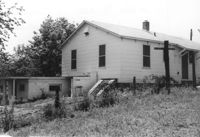
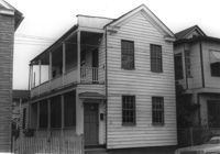
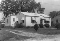
House on site affected by the construction of the Crosstown. Address: 506 Rutledge Avenue. Surveyor notations on back of photo: "Dkt.: 10.524. Property owner: Stephen B. Graham, et al. Tract: 113. Station: 86+50 Lt. Date: Dec. 1, 1964. In R/W - Bought." [See collection description for explanation of surveyor notations.]
House on site affected by the construction of the Crosstown. Address: 120 Sheppard Street. Surveyor notations on back of photo: "Dkt.: 10.524. Property owner: Jackson T. Rhodes. Tract: 142. Station: 18+25 Lt. S.B. lane. Date: Dec. 2, 1964. Condemned." [See collection description for explanation of surveyor notations.]
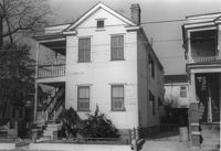
House on site affected by the construction of the Crosstown. Address: 128 Sheppard Street. Surveyor notations on back of photo: "Dkt.: 10.524. Property owner: Kawarsuan, Inc. Tract: 133. Station: 16+40 Lt. S.B. lane. Date: Dec. 2, 1964. Condemned." [See collection description for explanation of surveyor notations.]
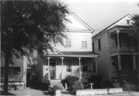
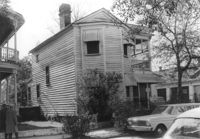
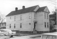
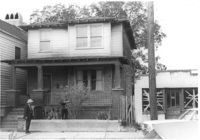
House on site affected by the construction of the Crosstown. Address: 130 Sheppard Street. Surveyor notations on back of photo: "Dkt.: 10.524. Property owner: Charles J. Brendt. Tract: 132. Station: 91+90 Lt. Date: Dec. 2, 1964. In R/W - Bought." [See collection description for explanation of surveyor notations.]
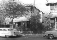
House on site affected by the construction of the Crosstown. Address: 127 Sheppard Street. Surveyor notations on back of photo: "Dkt.: 10.524. Property owner: Essie W. Jenkins. Tract: 129. Station: 91+50 Rt. Date: Dec. 2, 1964. In R/W - Bought." [See collection description for explanation of surveyor notations.]
House on site affected by the construction of the Crosstown. Address: 130 Sheppard Street. Surveyor notations on back of photo: "Dkt.: 10.524. Property owner: Charles J. Brendt. Tract: 132. Station: 91+90 Lt. Date: Dec. 2, 1964. In R/W - Bought." [See collection description for explanation of surveyor notations.]
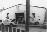
Bush's Auto Repair Shop on site affected by the construction of Interstate 26 (I-26). Address: 44 Sheppard Street. Mechanics working on car in garage bay. Surveyor notations on back of photo: "Dkt.: 10.517. Property owner: S.E. Jenkins. Tract: 71. Station: 5960+15 CL - Line 3. Date: March 5, 1963. In R/W - Bought." [See collection description for explanation of surveyor notations.]
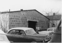
Bush's Auto Repair Shop (rear view) on site affected by the construction of Interstate 26 (I-26). Address: 44 Sheppard Street. Several cars in foreground. Surveyor notations on back of photo: "Dkt.: 10.517. Property owner: S.E. Jenkins. Tract: 71. Station: 5960+15 CL - Line 3. Date: March 5, 1963. In R/W - Bought." [See collection description for explanation of surveyor notations.]
Collins Auto Glass Service (rear view) on site affected by the construction of Interstate 26 (I-26). Address: 91 Lee Street. Surveyor notations on back of photo: "Dkt.: 10.517. Property owner: W.H. Yon. Tract: 56. Station: 34+30 Lt. - Route 17. Date: February 21, 1963." [See collection description for explanation of surveyor notations.]
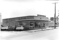
Lafayette Motors, on site affected by the construction of Interstate 26 (I-26). Address: 680 King Street. Surveyor notations on back of photo: "Dkt.: 10.517. Property owner: Raymond A. Wittschen. Tract: 122. Station: 28+35 Lt. Southbound Lane Route 17. Date: March 5, 1963. Proximity." [See collection description for explanation of surveyor notations.]
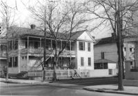
House (corner view, piazza side) on site affected by the construction of Interstate 26 (I-26). Address: 284 Coming Street. Surveyor notations on back of photo: "Dkt.: 10.517. Property owner: M.J. Christine Butt, Est. Tract: 103. Station: 22+40 Rt. Southbound Lane Route 17. Date: March 5, 1963. In R/W - Bought." [See collection description for explanation of surveyor notations.]
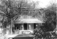
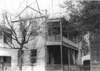
House on site affected by the construction of Interstate 26 (I-26). Address: 91 Fishburne Street. View of Street corner; corner of Fishburne Street and Coming Street. Surveyor notations on back of photo: "Dkt.: 10.517. Property owner: Annie E. Stossen. Tract: 105. Station: 22+65 Lt. Southbound Lane Route 17. Date: March 5, 1963. In R/W - Bought." [See collection description for explanation of surveyor notations.]
House (corner view, rear) on site affected by the construction of Interstate 26 (I-26). [Building address number 185.] Surveyor notations on back of photo: "Dkt.: 10.480. Property owner: Janet H. & Robert Carl Wilson. Tract: 262. Station: 5713+50 Lt. Date: May 31, 1961. In R/W - Bought." [See collection description for explanation of surveyor notations.]
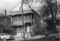
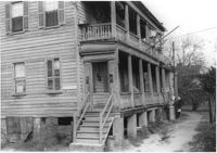
House (rear view) on site affected by the construction of Interstate 26 (I-26). Address: 83 Sheppard Street. Surveyor notations on back of photo: "Dkt.: 10.517. Property owner: Marguerite Gorman. Tract: 85. Station: 26+65 Lt. Northbound Lane Route 17. Date: March 5, 1963. In R/W - Bought." [See collection description for explanation of surveyor notations.]
House on site affected by the construction of Interstate 26 (I-26). Address: 83 Sheppard Street. Surveyor notations on back of photo: "Dkt.: 10.517. Property owner: Marguerite Gorman. Tract: 85. Station: 26+65 Lt. Northbound Lane Route 17. Date: March 5, 1963. In R/W - Bought." [See collection description for explanation of surveyor notations.]
Building (corner view, front) on site affected by the construction of the Crosstown. Address: 120 Drake Street (based on buildings across the street). Sign in front: Harrisson & Co. Fishing Tacking Hardware. Elevated roadway (presumably the off-ramp of the Grace Memorial Bridge) in background. Surveyor notations on back of photo: "Dkt.: 10.518. Property owner: Frank J. Kelly. Tract: 78. Station: 55+60 Rt. N.B. lane Route 17. Date: Mar. 7, 1963." [See collection description for explanation of surveyor notations.]
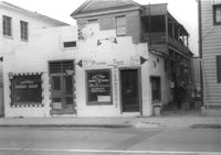
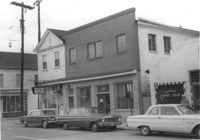
Building, on site affected by the construction of the Crosstown. Address: 209 Spring Street. Friendly Barber Shop and Spot Light Radio TV Service. Front facade has stepped parapet. Surveyor notations on back of photo: "Dkt.: 10.524. Property owner: Maybell Fields. Tract: 166. Station: 20+00 Rt. Spring Street. Date: Dec. 2, 1964." [See collection description for explanation of surveyor notations.]
Building, on site affected by the construction of the Crosstown. Address: 207 Spring Street. Sew-U-Save Shop. Surveyor notations on back of photo: "Dkt.: 10.524. Property owner: Olympia Papaeilidow. Tract: 167. Station: 20+35 Rt. Spring Street. Date: Dec. 2, 1964." [See collection description for explanation of surveyor notations.]
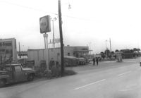
Shell gas station (rear view) on site affected by the construction of the Crosstown. Address: 233 Spring Street. Surveyor notations on back of photo: "Dkt.: 10.524. Property owner: Shell Oil Co. Tract: 155. Station: 9+00 Rt. Spring Street. Date: Dec. 2, 1965." [See collection description for explanation of surveyor notations.]
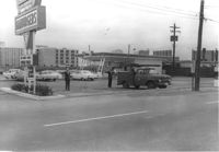
Hardee's, on site affected by the construction of the Crosstown. Address: 223 Spring Street. Surveyor notations on back of photo: "Dkt.: 10.524. Property owner: Sarah Chinnis Sanders. Tract: 157. Station: 14+60 Rt. Spring Street. Date: Dec. 2, 1964." [See collection description for explanation of surveyor notations.]
House on site affected by the construction of the Crosstown. Address: 114 Bogard Street. Surveyor notations on back of photo: "Dkt.: 10.524. Property owner: Francis Jenkins, et al. Tract: 64. Station: 75+70 CL Rt. Date: Oct. 14, 1964. In R/W - Bought." [See collection description for explanation of surveyor notations.]
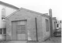
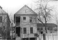
House (corner view) on site affected by the construction of Interstate 26 (I-26). Garage/shed at end of driveway. Surveyor notations on back of photo: "Dkt.: 10.480. Property owner: R.R. Barwick. Tract: 137. Station: 5655+80 Rt. Date: May 2, 1961. In R/W - Bought." [See collection description for explanation of surveyor notations.]
House on site affected by the construction of Interstate 26 (I-26). Address: 11 Brigade Street. Surveyor notations on back of photo: "Dkt.: 10.503. Property owner: Ada Williams. Tract: 42. Station: 5905+20 Rt. Date: Feb. 19, 1963. In R/W - Bought." [See collection description for explanation of surveyor notations.]
Row of houses on site affected by the construction of Interstate 26 (I-26). Address: 20-32 Brigade Street. Surveyor notations on back of photo: "Dkt.: 10.503. Property owner: Gussie Feldman. Tract: 41. Station: 5904+30 Rt. In R/W - Bought." [See collection description for explanation of surveyor notations.]
House on site affected by the construction of the Crosstown. Address: 190 Spring Street. Surveyor notations on back of photo: "Dkt.: 10.524. Property owner: E.H. Heidman, Est. Tract: 18. Station: 24± Lt. (Spring Street). Date: Oct. 13, 1964. Portion in R/W to be removed." [See collection description for explanation of surveyor notations.]
House on site affected by the construction of the Crosstown. Address: 22 Wescott Street. Surveyor notations on back of photo: "Dkt.: 10.524. Property owner: Ida J. Gantt. Tract: 10. Station: 61+20 Lt. Date: Oct. 13, 1964." [See collection description for explanation of surveyor notations.]
Limit your search
SCDOT Photographs: Properties in the Right-of-Way✖[remove]2,276