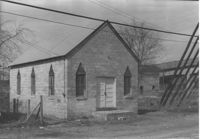
Building on site affected by the construction of the Crosstown. Address: 119 Drake Street (based on neighboring house number). Elevated roadway (presumably the off-ramp of the Grace Memorial Bridge) in background. Surveyor notations on back of photo: "Dkt.: 10.518. Property owner: Mt. Sinai Mission. Tract: 76. Station: 54+80 Rt. N.B. lane Route 17. Date: Mar. 7, 1963. In R/W - Bought." [See collection description for explanation of surveyor notations.]
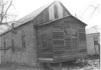
Building (rear view) on site affected by the construction of the Crosstown. Address: 119 Drake Street (based on neighboring house number). Surveyor notations on back of photo: "Dkt.: 10.518. Property owner: Mt. Sinai Mission. Tract: 76. Station: 54+80 Rt. N.B. lane Route 17. Date: Mar. 7, 1963. In R/W - Bought." [See collection description for explanation of surveyor notations.]
Right of way--South Carolina--Charleston County, Highway planning--South Carolina--Charleston County, Vernacular architecture--South Carolina--Charleston County, Lost architecture--South Carolina--Charleston County✖[remove]12