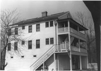
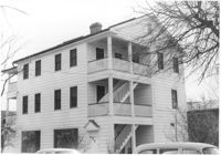
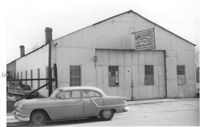
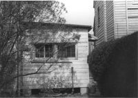
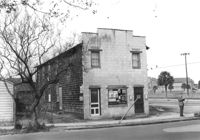
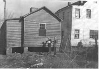
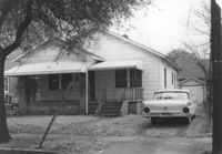
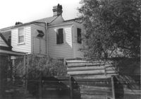
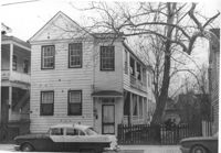
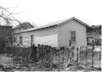
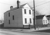
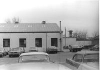
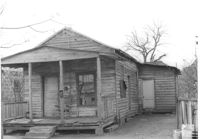
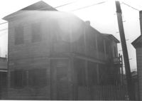
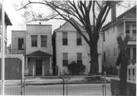
Cole Lumber Company, presumably main office building, on site affected by the construction of Interstate 26 (I-26). Address from 1961 City Directory: 293 Huger Street. Address from 1951 Sanborn Map: 17 Huger Street. Surveyor notations on back of photo: "Dkt.: 10.517. Property owner: Charles E. Cole Lumber Co. Tract 1. Station: 5937+70 Lt. Date: February 21, 1963." [See collection description for explanation of surveyor notations.]
Cole Lumber Company, presumably main office building, on site affected by the construction of Interstate 26 (I-26). Address from 1961 City Directory: 293 Huger Street. Address from 1951 Sanborn Map: 17 Huger Street. Surveyor notations on back of photo: "Dkt.: 10.517. Property owner: Cole Lumber Co. Tract 1. Station: 5937+70 Lt. Date: March 5, 1963. In R/W - Bought." [See collection description for explanation of surveyor notations.]
Cole Lumber Company, presumably main office building, on site affected by the construction of Interstate 26 (I-26). Address from 1961 City Directory: 293 Huger Street. Address from 1951 Sanborn Map: 17 Huger Street. Surveyor notations on back of photo: "Dkt.: 10.517. Property owner: Cole Lumber Co. Tract 1. Station: 5937+70 Lt. Date: March 5, 1963. In R/W - Bought." [See collection description for explanation of surveyor notations.]
Cole Lumber Company, presumably main office building, on site affected by the construction of Interstate 26 (I-26). Address from 1961 City Directory: 293 Huger Street. Address from 1951 Sanborn Map: 17 Huger Street. Surveyor notations on back of photo: "Dkt.: 10.517. Property owner: Charles E. Cole Lumber Co. Tract 1. Station: 5937+70 Lt. Date: February 21, 1963." [See collection description for explanation of surveyor notations.]
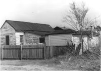
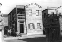
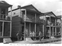
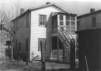
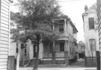
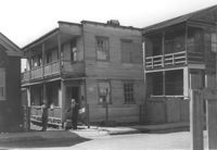
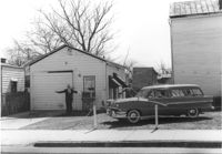
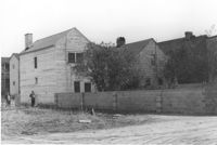
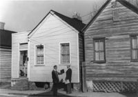
Lot with three dwellings, on site affected by the construction of Interstate 26 (I-26). Address 13-27 C Street. Appears to be a multi-family residence. Surveyor notations on back of photo: "Dkt.: 10.517. Property owner: J.W.C. Bischoff. Tract: 34, 35, and 36. Station: 5947+00 - 5947+75 Rt. & Lt. Date: February 21, 1963. In R/W - Bought." [See collection description for explanation of surveyor notations.]
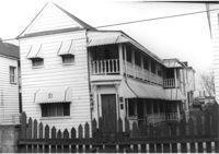
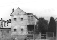
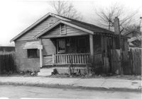
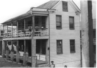
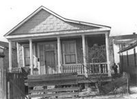
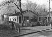
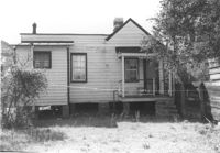
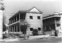
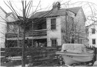
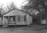
House [on St. Phillip Street] on site affected by the construction of Interstate 26 (I-26). Address:260 St. Philip Street. (1951 Sanborn map indicates the address is 274 St. Philip Street.) Surveyor notations on back of photo: "Dkt.: 10.517. Property owner: Robert Davis, et al. Tract: 91. Station: 25+00 Rt. Northbound Lane Route 17. Date: March 5, 1963. In R/W - Bought." [See collection description for explanation of surveyor notations.]
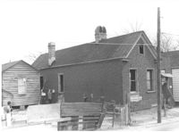
House and neighboring houses (rear view) on site affected by the construction of Interstate 26 (I-26). Address: 79 Cooper Street. Surveyor notations on back of photo: "Dkt.: 10.517. Property owner: John D. Bendt Jr. Tract: 69. Station: 5958+70 Rt. - Line 4, 5959+00 Rt. - Line 4. Date: March 5, 1963. In R/W - Bought." [See collection description for explanation of surveyor notations.]
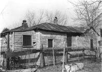
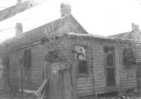
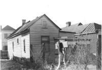
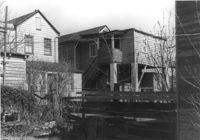
House in dilapidated condition (rear view) and smaller dwelling, on site affected by the construction of Interstate 26 (I-26). Address: 35 Poinsett Street. Surveyor notations on back of photo: "Dkt.: 10.503. Property owner: Manuel F. Fernandez. Tract: 106. Station: 5922+50 Lt. Date: Feb. 20, 1963. In R/W - Bought." [See collection description for explanation of surveyor notations.]
House on site affected by the construction of Interstate 26 (I-26). Address: 141 Cooper Street. (1951 Sanborn map indicates the address is 81 Cooper Street.) Surveyor notations on back of photo: "Dkt.: 10.517. Property owner: John D. Bendt Jr. Tract: 68. Station: 5958+70 Rt. - Line 4. Date: March 5, 1963. In R/W - Bought." [See collection description for explanation of surveyor notations.]
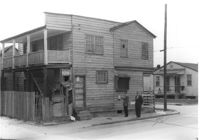
Garbini Auto Service -- General Auto Repair - Body and Paint Shop, on site affected by the construction of Interstate 26 (I-26). Address: 89 Lee Street. Surveyor notations on back of photo: "Dkt.: 10.517. Property owner: W.H. Yon. Tract: 56. Station: 35+20 CL - Route 17. Date: February 21, 1963. Partially in R/W." [See collection description for explanation of surveyor notations.]
Garbini Auto Service -- General Auto Repair - Body and Paint Shop, on site affected by the construction of Interstate 26 (I-26). Address: 89 Lee Street. Surveyor notations on back of photo: "Dkt.: 10.517. Property owner: W.H. Yon. Tract: 56. Station: 35+20 CL - Route 17. Date: February 21, 1963. Partially in R/W." [See collection description for explanation of surveyor notations.]
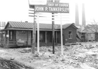
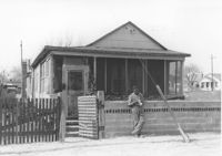
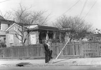
Lot on site affected by the construction of the Crosstown. Address: 32 Lee Street (south side of street). Sign for John P. Tankersley Insurance, East of Cooper. House/structure abuts lot; posted sign indicates it is closed by the Board of Health. Industrial smokestacks in background (Cigar Factory?). Surveyor notations on back of photo: "Dkt.: 10.518. Property owner: Clifton Iron. Tract: 68. Station: 52+35 Lt. N.B. lane Route 17. Date: Mar. 7, 1963. In R/W - Bought." [See collection description for explanation of surveyor notations.]
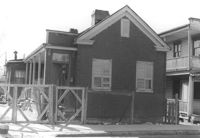
House (freedman's cottage) (rear view) on site affected by the construction of the Crosstown. Address: 115 America Street. Surveyor notations on back of photo: "Dkt.: 10.518. Property owner: Jerusalem Baptist Church. Tract: 60. Station: 49+10 Rt. N.B. lane Route 17. Date: Mar. 7, 1963." [See collection description for explanation of surveyor notations.]
House (freedman's cottage) (rear view) on site affected by the construction of Interstate 26 (I-26). Address: 18 C Street. (1951 Sanborn map indicates the address is 16 C Street.) Surveyor notations on back of photo: "Dkt.: 10.517. Property owner: Virgil German, et al. Tract: 32. Station: 5948+80 Lt. - Line 6. Date: February 21, 1963. In R/W - Bought." [See collection description for explanation of surveyor notations.]
House (freedman's cottage) (rear view) on site affected by the construction of Interstate 26 (I-26). Address: 23 D Street. Surveyor notations on back of photo: "Dkt.: 10.517. Property owner: Maggie Tobias. Tract: 4. Station: 5945+65 Rt. on CL. Date: February 21, 1963. In R/W - Bought." [See collection description for explanation of surveyor notations.]
House (rear view) on site affected by the construction of Interstate 26 (I-26). Address: southeast corner of E Street and C Street. Across the street from Washington Grocery. View of street corner. Surveyor notations on back of photo: "Dkt.: 10.517. Property owner: Henry L. Perkins, et al. Tract: 28. Station: 5947+20 Lt. - Line 6. Date: February 21, 1963. In R/W - Bought." [See collection description for explanation of surveyor notations.]
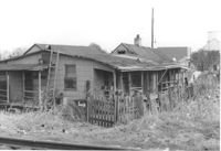
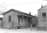
House (freedman's cottage) on site affected by the construction of Interstate 26 (I-26). Address: 23 D Street. Surveyor notations on back of photo: "Dkt.: 10.517. Property owner: Maggie Tobias. Tract: 4. Station: 5945+65 Rt. on CL. Date: February 21, 1963. In R/W - Bought." [See collection description for explanation of surveyor notations.]
House in dilapidated condition (rear view) on site affected by the construction of Interstate 26 (I-26). Address: southeast corner of E Street and C Street, behind corner store. Surveyor notations on back of photo: "Dkt.: 10.517. Property owner: Arthur Lee Nelson. Tract: 29. Station: 5947+65 Lt. - Line 6. Date: February 21, 1963. In R/W - Bought." [See collection description for explanation of surveyor notations.]
House (rear view) on site affected by the construction of Interstate 26 (I-26). Address: 12 D Street. Surveyor notations on back of photo: "Dkt.: 10.517. Property owner: Frank Lea. Tract: 13. Station: 5944+90 CL - Line 6. Date: February 21, 1963. In R/W - Bought." [See collection description for explanation of surveyor notations.]
House (rear view) on site affected by the construction of Interstate 26 (I-26). Address: 19 D Street. Surveyor notations on back of photo: "Dkt.: 10.517. Property owner: Mary M. Lee. Tract: 10. Station: 5944+50 CL - Line 1. Date: February 21, 1963. In R/W - Bought." [See collection description for explanation of surveyor notations.]
House on site affected by the construction of Interstate 26 (I-26). Address: 19 D Street. Surveyor notations on back of photo: "Dkt.: 10.517. Property owner: Mary M. Lee. Tract: 10. Station: 5944+50 CL - Line 1. Date: February 21, 1963. In R/W - Bought." [See collection description for explanation of surveyor notations.]
House on site affected by the construction of Interstate 26 (I-26). Address: 12 D Street. Surveyor notations on back of photo: "Dkt.: 10.517. Property owner: Frank Lea. Tract: 13. Station: 5944+90 CL - Line 6. Date: February 21, 1963. In R/W - Bought." [See collection description for explanation of surveyor notations.]
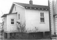
House on site affected by the construction of Interstate 26 (I-26). Address: 15 Wood Street. Railroad tracks nearby. Surveyor notations on back of photo: "Dkt.: 10.503. Property owner: Abe Finklestein, et al. Tract: 33. Station: 5900+75 Lt. Date: Feb. 19, 1963. In R/W - Bought." [See collection description for explanation of surveyor notations.]
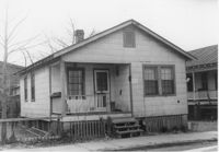
House on site affected by the construction of Interstate 26 (I-26). Address: 50 Sheppard Street. Surveyor notations on back of photo: "Dkt.: 10.517. Property owner: Nellie T. France. Tract: 75. Station: 5959+35 Rt. - Line 3. Date: March 5, 1963. In R/W - Bought." [See collection description for explanation of surveyor notations.]
House on site affected by the construction of Interstate 26 (I-26). Address: 48 Sheppard Street. Surveyor notations on back of photo: "Dkt.: 10.517. Property owner: Michael Criley. Tract: 74. Station: 5959+75 CL - Line 3. Date: March 5, 1963. In R/W - Bought." [See collection description for explanation of surveyor notations.]
Corner grocery store on site affected by the construction of the Crosstown. Address: 121 America Street. View of street corner (America Street and Lee Street). Surveyor notations on back of photo: "Dkt.: 10.518. Property owner: Vallie Talbert. Tract: 58. Station: 49+50 Lt. N.B. lane Route 17. Date: Mar. 7, 1963." [See collection description for explanation of surveyor notations.]
House in dilapidated condition (freedman's cottage) on site affected by the construction of Interstate 26 (I-26). Address: 6 C Street. Number 14 painted on brick by front door. Surveyor notations on back of photo: "Dkt.: 10.517. Property owner: Mary Wayman. Tract: 30. Station: 5948+20 Lt. - Line 6. Date: February 21, 1963. In R/W - Bought." [See collection description for explanation of surveyor notations.]
House on site affected by the construction of the Crosstown. Address: 88 Hanover Street. Surveyor notations on back of photo: "Dkt.: 10.518. Property owner: Jerusalem Baptist Church. Tract: 43. Station: 43+90 CL line 9 north of Cooper Street. Date: Mar. 6, 1963." [See collection description for explanation of surveyor notations.]
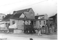
Houses on site affected by the construction of Interstate 26 (I-26). Address: 30 Brigade Street. Neighboring houses on either side also in photo. Written on border of photo: Men on projected R/W of Main Line (see plans). Surveyor notations on back of photo: "Dkt.: 10.503. Property owner: Gussie Feldman, et al. Tract: 41. Station: 5904+15 Rt. Date: Feb. 19, 1963. In R/W - Bought." [See collection description for explanation of surveyor notations.]
Exterior wall of dilapidated house on site affected by the construction of Interstate 26 (I-26). Address: southeast corner of E Street and C Street, behind corner store. Surveyor notations on back of photo: "Dkt.: 10.517. Property owner: Arthur Lee Nelson. Tract: 29. Station: 5947+65 Lt. - Line 6. Date: February 21, 1963. In R/W - Bought." [See collection description for explanation of surveyor notations.]
House on site affected by the construction of Interstate 26 (I-26). Address: 43 C Street. (1951 Sanborn map indicates the address is 9 C Street.) Surveyor notations on back of photo: "Dkt.: 10.517. Property owner: R.F. Momier, Est. Tract: 23. Station: 5944+60 Lt. - Line 6. Date: February 21, 1963. In R/W - Bought." [See collection description for explanation of surveyor notations.]
House (rear view) on site affected by the construction of Interstate 26 (I-26). Address: 21 D Street (see 1951 Sanborn Map). Surveyor notations on back of photo: "Dkt.: 10.517. Property owner: Ida B. Moore. Tract 3. Station: 5943+35 Rt. on CL. Date: February 21, 1963. In R/W - Bought." [See collection description for explanation of surveyor notations.]
House on site affected by the construction of Interstate 26 (I-26). Address: 18 D Street. Surveyor notations on back of photo: "Dkt.: 10.517. Property owner: Annie Marie Brown. Tract: 7. Station: 5944+15 CL - Line 6. Date: February 21, 1963. In R/W - Bought." [See collection description for explanation of surveyor notations.]
House on site affected by the construction of Interstate 26 (I-26). Address: 19 Boyer Street. Surveyor notations on back of photo: "Dkt.: 10.503. Property owner: Ernest Garner. Tract: 80. Station: 5914+35 Lt. Date: Feb. 20, 1963. In R/W - Bought." [See collection description for explanation of surveyor notations.]
House on site affected by the construction of Interstate 26 (I-26). Address: 21 D Street. Surveyor notations on back of photo: "Dkt.: 10.517. Property owner: Ida B. Moore. Tract 3. Station: 5943+35 Rt. on CL. Date: February 21, 1963. In R/W - Bought." [See collection description for explanation of surveyor notations.]
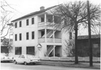
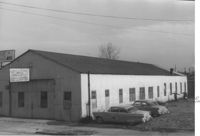
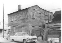
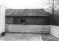
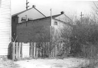
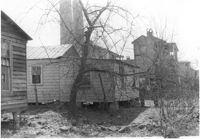
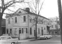
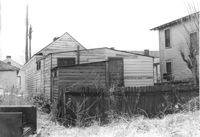
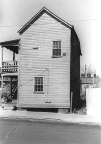
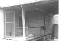
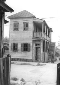
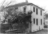
Cole Lumber Company structure (rear view), on site affected by the construction of Interstate 26 (I-26). Address from 1961 City Directory: 293 Huger Street. Address from 1951 Sanborn Map: 17 Huger Street. Surveyor notations on back of photo: "Dkt.: 10.517. Property owner: Cole Lumber Co. Tract 1. Station: 5940+00 Lt. Date: February 21, 1963." [See collection description for explanation of surveyor notations.]
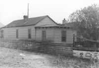
Garage on site by the construction of Interstate 26 (I-26). Address: 1215 King Street. Surveyor notations on back of photo: "Dkt.: 10.503. Property owner: Mary M.J. Clifton. Tract: 15. Station: 5894+05 Lt. Date: Feb. 19, 1963. In R/W - Bought." [See collection description for explanation of surveyor notations.]
House (freedman's cottage) (rear view) on site affected by the construction of Interstate 26 (I-26). Address: 13 Riker Street. Surveyor notations on back of photo: "Dkt.: 10.503. Property owner: Henry Yaschik. Tract: 71. Station: 5911+35 Lt. Date: Feb. 20, 1963. In R/W - Bought." [See collection description for explanation of surveyor notations.]
Lot on site affected by the construction of the Crosstown. Address: 51 Aiken Street. Surveyor notations on back of photo: "Dkt.: 10.518. Property owner: Julia M. Pritchard. Tract: 52. Station: 46+50 Rt. N.B. lane Route 17. Date: Mar. 7, 1963. In R/W - Bought." [See collection description for explanation of surveyor notations.]
House (rear view) on site affected by the construction of Interstate 26 (I-26). Address: 27 Indian Street. ((1951 Sanborn map indicates the address is 17 Indian Street.) Surveyor notations on back of photo: "Dkt.: 10.503. Property owner: Eloise Williams. Tract: 76. Station: 5913+30 Lt. Date: Feb. 20, 1963. In R/W - Bought." [See collection description for explanation of surveyor notations.]
House on site affected by the construction of Interstate 26 (I-26). Address: 27 Indian Street. (1951 Sanborn map indicates the address is 17 Indian Street.) Surveyor notations on back of photo: "Dkt.: 10.503. Property owner: Eloise Williams. Tract: 76. Station: 5913+30 Lt. Date: Feb. 20, 1963. In R/W - Bought." [See collection description for explanation of surveyor notations.]
House on site affected by the construction of Interstate 26 (I-26). Address: 12 Maple Street. Surveyor notations on back of photo: "Dkt.: 10.503. Property owner: Atlantic Coast Life Ins. Co., et al. Tract: 52. Station: 5906+45 Rt. Date: Feb. 19, 1963. In R/W - Bought." [See collection description for explanation of surveyor notations.]
House (side view) on site affected by the construction of Interstate 26 (I-26). Address: 22 Riker Street (rear). Surveyor notations on back of photo: "Dkt.: 10.503. Property owner: Gibbs Mitchell, Est. Tract: 66. Station: 5910+00 Rt. Date: Feb. 20, 1963. In R/W - Bought." [See collection description for explanation of surveyor notations.]
House on site affected by the construction of Interstate 26 (I-26).Address: 8 Maple Street. Surveyor notations on back of photo: "Dkt.: 10.503. Property owner: Atlantic Coast Life Ins. Co., et al. Tract: 50. Station: 5906+30 Rt. Date: Feb. 19, 1963. In R/W - Bought." [See collection description for explanation of surveyor notations.]
House on site affected by the construction of Interstate 26 (I-26). Address: 10 Maple Street. Surveyor notations on back of photo: "Dkt.: 10.503. Property owner: Gertrude C. Tindall, Est. Tract: 51. Station: 5906+40 Rt. Date: Feb. 19, 1963. In R/W - Bought." [See collection description for explanation of surveyor notations.]
House on site affected by the construction of Interstate 26 (I-26). Address: 40 Enston Avenue [40 North Enston Avenue]. Surveyor notations on back of photo: "Dkt.: 10.503. Property owner: George Stamos, et al. Tract: 2. Station: 5891+35 Rt. Date: Feb. 19, 1963. In R/W - Bought." [See collection description for explanation of surveyor notations.]
Rear view of house and lot on site affected by the construction of the Crosstown. Address: 75 Lee Street. Surveyor notations on back of photo: "Dkt.: 10.518. Property owner: Virginia E.R. Ehlers. Tract: 28. Station: 40+50 Rt. S.B. lane of Route 17. Date: Mar. 6, 1963. In R/W - Bought. [See collection description for explanation of surveyor notations.]
House (side view) on site affected by the construction of the Crosstown. Address180 Nassau Street. Surveyor notations on back of photo: "Dkt.: 10.518. Property owner: Audrey Lewis Clark, et al. Tract: 34. Station: 42+05 Rt. S.B. lane Route 17. Date: Mar. 6, 1963. In R/W - Bought. [See collection description for explanation of surveyor notations.]
House (rear view) on site affected by the construction of the Crosstown. Address: 178 Nassau Street. Surveyor notations on back of photo: "Dkt.: 10.518. Property owner: Euphrasia E. Lewis. Tract: 33. Station: 42+10 Lt. N.B. lane Route 17. Date: Mar. 6, 1963. In R/W - Bought. [See collection description for explanation of surveyor notations.]
House (rear view) on site affected by the construction of the Crosstown. Address: 182 Nassau Street. Surveyor notations on back of photo: "Dkt.: 10.518. Property owner: Euphrasia E. Lewis. Tract: 35. Station: 42+00 Lt. S.B. lane Route 17. Date: Mar. 6, 1963. In R/W - Bought. [See collection description for explanation of surveyor notations.]
House on site affected by the construction of the Crosstown. Address: 96 Sheppard Street. Surveyor notations on back of photo: "Dkt.: 10.518. Property owner: Celia McFadden. Tract: 18. Station: 30+10 Lt. Sheppard Street. Date: Mar. 6, 1963. In R/W - Bought. [See collection description for explanation of surveyor notations.]
House (rear view) on site affected by the construction of the Crosstown. Address: 117 Drake Street. Industrial smokestacks in background (Cigar Factory?). Surveyor notations on back of photo: "Dkt.: 10.518. Property owner: Ida Green Jenkins. Tract: 77. Station: 54+80 Rt. Date: Mar. 7, 1963. In R/W - Bought." [See collection description for explanation of surveyor notations.]
House (rear view) on site affected by the construction of Interstate 26 (I-26). Address; 85 Sheppard Street. Surveyor notations on back of photo: "Dkt.: 10.517. Property owner: Douglas E. Holmes. Tract: 86. Station: 26+35 Lt. Northbound Lane Route 17. Date: March 5, 1963. In R/W - Bought." [See collection description for explanation of surveyor notations.]
House on site affected by the construction of Interstate 26 (I-26). Address: 89 Sheppard Street. Surveyor notations on back of photo: "Dkt.: 10.517. Property owner: Cecil Taylor, et al. Tract: 88. Station: 25+75 Lt. Northbound Lane - Route 17. Date: March 5, 1963. In R/W - Bought." [See collection description for explanation of surveyor notations.]
House on site affected by the construction of Interstate 26 (I-26). Address: 85 Sheppard Street. Surveyor notations on back of photo: "Dkt.: 10.517. Property owner: Douglas E. Holmes. Tract: 86. Station: 26+35 Lt. Northbound Lane Route 17. Date: March 5, 1963. In R/W - Bought." [See collection description for explanation of surveyor notations.]
House on site affected by the construction of Interstate 26 (I-26). Address: 87 Sheppard Street. Surveyor notations on back of photo: "Dkt.: 10.517. Property owner: Elsie B. Mappus. Tract: 87. Station: 26+00 CL Northbound Lane - Route 17. Date: March 5, 1963. In R/W - Bought." [See collection description for explanation of surveyor notations.]
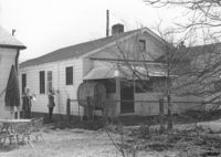
Push Grocery at the southwest corner of Fishburne and St. Philip Streets (rear corner/southeast elevation), on site affected by the construction of Interstate 26 (I-26). Address: 77 Fishburne Street. View of street corner. Willie's Grill, across the street, in background. Surveyor notations on back of photo: "Dkt.: 10.517. Property owner: Margaret J. Finn. Tract: 110. Station: 24+50 Lt. Southbound Lane Route 17. Date: March 5, 1963. In R/W - Bought." [See collection description for explanation of surveyor notations.]
House on site affected by the construction of the Crosstown. Address: 20 Cooper Street (based on 1951 Sanborn Map, perhaps behind 22 Cooper Street). Surveyor notations on back of photo: "Dkt.: 10.518. Property owner: Toots Brown. Tract: 79. Station: 54+25 Rt. N.B. lane Route 17. Date: Mar. 7, 1963. In R/W - Bought." [See collection description for explanation of surveyor notations.]
Houses (review view) on site affected by the construction of the Crosstown. Address: 82 Cooper Street. Surveyor notations on back of photo: "Dkt.: 10.518. Property owner: O.L. Scott. Tract: 8. Station: 38+75 CL N.B. lane Route 17. Date: Mar. 6, 1963. In R/W - Bought. [See collection description for explanation of surveyor notations.]
House (corner view) on site affected by the construction of Interstate 26 (I-26). Address: 286 Coming Street. Surveyor notations on back of photo: "Dkt.: 10.517. Property owner: Wilhelmina J. Fields, Est. Tract: 104. Station: 22+60 Lt. Southbound Lane Route 17. Date: March 5, 1963. In R/W - Bought." [See collection description for explanation of surveyor notations.]
House (rear view) on site affected by the construction of Interstate 26 (I-26). Address: 91-93 Sheppard Street. Surveyor notations on back of photo: "Dkt.: 10.517. Property owner: Elsie Hilton Mattson. Tract: 89. Station: 25+30 Lt. Northbound Lane - Route 17. Date: March 5, 1963. In R/W - Bought." [See collection description for explanation of surveyor notations.]
House (rear view) on site affected by the construction of Interstate 26 (I-26). Address: 91-93 Sheppard Street. Surveyor notations on back of photo: "Dkt.: 10.517. Property owner: Elsie Hilton Mattson. Tract: 89. Station: 25+30 Lt. Northbound Lane - Route 17. Date: March 5, 1963. In R/W - Bought." [See collection description for explanation of surveyor notations.]
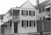
House on site affected by the construction of Interstate 26 (I-26). Address: 273 St. Philip Street. Surveyor notations on back of photo: "Dkt.: 10.517. Property owner: Victor A. Martin. Tract: 92. Station: 24+00 Rt. Northbound Lane Route 17. Date: March 5, 1963. In R/W - Bought." [See collection description for explanation of surveyor notations.]
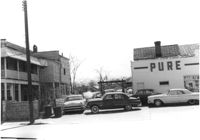
Pure Gas Station: and neighboring house, on site affected by the construction of the Crosstown. Address: 522 Meeting Street. Surveyor notations on back of photo: "Dkt.: 10.518. Property owner: Pure Oil Co. Tract: 1. Station: 38+40 on CL S.B. lane Route 17. Date: Mar. 6, 1963. In R/W - Bought. [See collection description for explanation of surveyor notations.]
House on site affected by the construction of the Crosstown. Address: 177 Nassau Street. 179 Nassau Street partly seen to its right. Surveyor notations on back of photo: "Dkt.: 10.518. Property owner: Estelle Tompkins. Tract: 26. Station: 41+25 Lt. N.B. lane Route 17. Date: Mar. 6, 1963. Proximity. [See collection description for explanation of surveyor notations.]
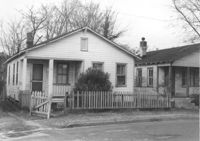
House with picket fence, on site affected by the construction of the Crosstown. Address: 172 Nassau Street. Surveyor notations on back of photo: "Dkt.: 10.518. Property owner: Philip Baskerville, Est. Tract: 30. Station: 42+00 Rt. N.B. lane Route 17. Date: Mar. 6, 1963. In R/W - Bought. [See collection description for explanation of surveyor notations.]
House (corner view) on site affected by the construction of the Crosstown. Address: 182 Nassau Street. View of street corner. Surveyor notations on back of photo: "Dkt.: 10.518. Property owner: Euphrasia E. Lewis. Tract: 35. Station: 42+00 Lt. S.B. lane Route 17. Date: Mar. 6, 1963. In R/W - Bought. [See collection description for explanation of surveyor notations.]
Freedman's cottage (rear view) on site affected by the construction of the Crosstown. Address: 169 Nassau Street. Surveyor notations on back of photo: "Dkt.: 10.518. Property owner: R.F. Momier. Tract: 23. Station: 40+85 Rt. N.B. lane Route 17. Date: Mar. 6, 1963. In R/W - Bought. [See collection description for explanation of surveyor notations.]
Freedman's cottage on site affected by the construction of the Crosstown. Address: 173 Nassau Street. Surveyor notations on back of photo: "Dkt.: 10.518. Property owner: Isiah Bryant, et al. Tract: 25. Station: 41+00 Lt. N.B. lane Route 17. Date: Mar. 6, 1963. In R/W - Bought. [See collection description for explanation of surveyor notations.]
Structure on site affected by the construction of the Crosstown. Address: 510 Meeting Street. Surveyor notations on back of photo: "Dkt.: 10.518. Property owner: Robert L. Knoth. Tract: 14. Station: 5963+55 Rt. Line 3, S.B. lane of Route 17. Date: Mar. 6, 1963. Damage. [See collection description for explanation of surveyor notations.]
House on site affected by the construction of the Crosstown. Address: 76 Cooper Street. Surveyor notations on back of photo: "Dkt.: 10.518. Property owner: Lewis Rosen. Tract: 11. Station: 5965+10 CL Line 3, S.B. lane Route 17. Date: Mar. 6, 1963. In R/W - Bought. [See collection description for explanation of surveyor notations.]
Houses on site affected by the construction of the Crosstown. Address: 73 Cooper Street. Surveyor notations on back of photo: "Dkt.: 10.518. Property owner: Centeur Corp. Tract: 13. Station: 5963+90 Rt. Line 3 of the S.B. lane of Route 17. Date: Mar. 6, 1963. Proximity. [See collection description for explanation of surveyor notations.]
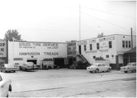
Gibson Tire Service / Hawkinson Treads on site affected by the construction of Interstate 26 (I-26). Address: 521 Meeting Street or 523 Meeting Street. Corner of Meeting Street and Lee Street. Surveyor notations on back of photo: "Dkt.: 10.517. Property owner: Thomas P. Gibson. Tract: 59. Station: 36+50 Rt. & Lt. Southbound Route 17. Date: May 30, 1963." [See collection description for explanation of surveyor notations.]
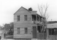
Ray Waits Mechanic/Body Shop (one end of building, front) on site affected by the construction of Interstate 26 (I-26). Address: 11 Walnut Street. Surveyor notations on back of photo: "Dkt.: 10.517. Property owner: Roy Waites [sic] Motors, Inc. Tract: 45. Station: 5950± Lt. - Line 6. Date: February 21, 1963." [See collection description for explanation of surveyor notations.]
House (rear view) on site affected by the construction of Interstate 26 (I-26). Address: 47 C Street. (1951 Sanborn map indicates the address is 16 C Street.) Surveyor notations on back of photo: "Dkt.: 10.517. Property owner: James B. Walker, et al. Tract: 6. Station: 5944+00 Lt. - Line 6. Date: February 21, 1963. In R/W - Bought." [See collection description for explanation of surveyor notations.]
House on site affected by the construction of Interstate 26 (I-26). Address: southeast corner of E Street and C Street. View of street corner. Surveyor notations on back of photo: "Dkt.: 10.517. Property owner: Henry L. Perkins, et al. Tract: 28. Station: 5947+20 Lt. - Line 6. Date: February 21, 1963. In R/W - Bought." [See collection description for explanation of surveyor notations.]
House on site affected by the construction of Interstate 26 (I-26). Address: 37 C Street. (1951 Sanborn map indicates the address is 25 C Street) Surveyor notations on back of photo: "Dkt.: 10.517. Property owner: Sara Wilson. Tract: 25. Station: 5945+40 Lt. - Line 6. Date: February 21, 1963. In R/W - Bought." [See collection description for explanation of surveyor notations.]
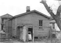
House in dilapidated condition on site affected by the construction of Interstate 26 (I-26). Address: 5 C Street. Surveyor notations on back of photo: "Dkt.: 10.517. Property owner: John B. Kelly, Est. Tract: 42. Station: 5950+30 Lt. Line 2. Date: February 21, 1963. In R/W - Bought." [See collection description for explanation of surveyor notations.]
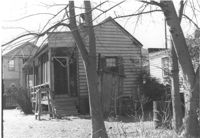
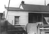
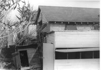
Porch of dilapidated structure on site affected by the construction of Interstate 26 (I-26). Address: 3 C Street. Surveyor notations on back of photo: "Dkt.: 10.517. Property owner: J.W. Prescott. Tract: 43. Station: 5950+60 CL - Line 2. Date: February 21, 1963. In R/W - Bought." [See collection description for explanation of surveyor notations.]
House (rear view) on site affected by the construction of Interstate 26 (I-26). Address: 24 C Street. Surveyor notations on back of photo: "Dkt.: 10.517. Property owner: Dorothy Bolds, et al. Tract: 26. Station: 5945+80 Lt. - Line 6. Date: February 21, 1963. In R/W - Bought." [See collection description for explanation of surveyor notations.]
House on site affected by the construction of Interstate 26 (I-26). Address: 24 C Street. Surveyor notations on back of photo: "Dkt.: 10.517. Property owner: Dorothy Bolds, et al. Tract: 26. Station: 5945+80 Lt. - Line 6. Date: February 21, 1963. In R/W - Bought." [See collection description for explanation of surveyor notations.]
House in dilapidated condition (freedman's cottage) (rear view) on site affected by the construction of Interstate 26 (I-26). Address: 22 Poinsett Street. Surveyor notations on back of photo: "Dkt.: 10.503. Property owner: Emma J. Marjen Hoff, Est. Tract: 103. Station: 5921+70 CL. Date: Feb. 20, 1963. In R/W - Bought." [See collection description for explanation of surveyor notations.]
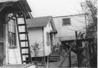
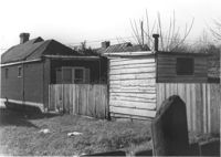
House (freedman's cottage) (rear view) on site affected by the construction of Interstate 26 (I-26). Address: 18 Riker Street. Fence and outbuilding in foreground. Surveyor notations on back of photo: "Dkt.: 10.503. Property owner: Mary Bradford, Est. Tract: 64. Station: 5910+40 Rt. & Lt. CL. Date: Feb. 20, 1963. In R/W - Bought." [See collection description for explanation of surveyor notations.]
House (rear view) on site by the construction of Interstate 26 (I-26). Address: 1213 King Street. Surveyor notations on back of photo: "Dkt.: 10.503. Property owner: Robert C. Benke, et al. Tract: 16. Station: 5894+90 Lt. Date: Feb. 19, 1963. In R/W - Bought." [See collection description for explanation of surveyor notations.]
House (rear view) on site by the construction of Interstate 26 (I-26). Address: 1215 King Street. Surveyor notations on back of photo: "Dkt.: 10.503. Property owner: Mary M.J. Clifton. Tract: 15. Station: 5894+60 Lt. Date: Feb. 19, 1963. In R/W - Bought." [See collection description for explanation of surveyor notations.]
House on site affected by the construction of Interstate 26 (I-26). Address: 15 Riker Street. Surveyor notations on back of photo: "Dkt.: 10.503. Property owner: Rosa Lee Seabrook. Tract: 70. Station: 5911+41 Lt. Date: Feb. 20, 1963. In R/W - Bought." [See collection description for explanation of surveyor notations.]
House on site affected by the construction of Interstate 26 (I-26). Address: 15 Riker Street. Surveyor notations on back of photo: "Dkt.: 10.503. Property owner: Rosa Lee Seabrook. Tract: 70. Station: 5911+40 Lt. Date: May 30, 1963. In R/W - Bought." [See collection description for explanation of surveyor notations.]
Houses (freedman's cottages) (rear view) on site affected by the construction of Interstate 26 (I-26). Address: 12-14 Riker Street. Surveyor notations on back of photo: "Dkt.: 10.503. Property owner: Jesse Williams. Tract: 62. Station: 5910+40 Lt. Date: Feb. 20, 1963. In R/W - Bought." [See collection description for explanation of surveyor notations.]
House (freedman's cottage) (rear view) on site affected by the construction of Interstate 26 (I-26). Address: 16 Riker Street. Surveyor notations on back of photo: "Dkt.: 10.503. Property owner: Mary M. Polite, Est. Tract: 63. Station: 5910+50 Lt. Date: Feb. 20, 1963. In R/W - Bought." [See collection description for explanation of surveyor notations.]
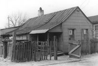
House (freedman's cottage) on site affected by the construction of Interstate 26 (I-26). Address: 16 Riker Street. Surveyor notations on back of photo: "Dkt.: 10.503. Property owner: Mary M. Polite, Est. Tract: 63. Station: 5910+50 Lt. Date: Feb. 20, 1963. In R/W - Bought." [See collection description for explanation of surveyor notations.]
Houses (freedman's cottages) on site affected by the construction of Interstate 26 (I-26). Address: 12-14 Riker Street. Surveyor notations on back of photo: "Dkt.: 10.503. Property owner: Jesse Williams. Tract: 62. Station: 5910+40 Lt. Date: Feb. 20, 1963. In R/W - Bought." [See collection description for explanation of surveyor notations.]
House on site affected by the construction of Interstate 26 (I-26). Address: 6 Maple Street. Surveyor notations on back of photo: "Dkt.: 10.503. Property owner: Atlantic Coast Life Ins. Co., et al. Tract: 49. Station: 5906+25 Lt. on CL. Date: Feb. 19, 1963. In R/W - Bought." [See collection description for explanation of surveyor notations.]
Houses (rear view) on site affected by the construction of the Crosstown. Address: 83 Lee Street. Surveyor notations on back of photo: "Dkt.: 10.518. Property owner: Simon Sumter. Tract: 3. Station: 39+15 Lt. S.B. lane Route 17. Date: Mar. 6, 1963. In R/W - Bought. [See collection description for explanation of surveyor notations.]
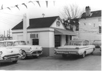
Small commercial building (used car sales) and parked cars, on site affected by the construction of Interstate 26 (I-26). Address: 646 King Street, southeast corner of Sheppard Street and King Street. Sign "GW" [guaranty/warranty] on pediment. Surveyor notations on back of photo: "Dkt.: 10.517. Property owner: W.L. McCrary, et al. Tract: 78. Station: 5962+30 CL - I26. Date: March 5, 1963. In R/W - Bought." [See collection description for explanation of surveyor notations.]
House [on Sheppard Street] (behind house in Photos 934- 935), on site affected by the construction of Interstate 26 (I-26). Address: 93A Sheppard Street (R) and 95 Sheppard Street (L). (1951 Sanborn map indicates the address is of 95 Sheppard as 93B Sheppard Street.) Surveyor notations on back of photo: "Dkt.: 10.517. Property owner: George A. Castens. Tract: 93. Station: 23+50 CL Northbound Lane Route 17. Date: March 5, 1963. In R/W - Bought." [See collection description for explanation of surveyor notations.]
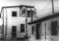
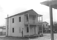
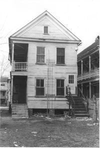
House (duplex) (corner view, rear) on site affected by the construction of Interstate 26 (I-26). Address: 103A-103B Sheppard Street. (1951 Sanborn map indicates the address is 99 Sheppard Street.) Surveyor notations on back of photo: "Dkt.: 10.517. Property owner: Hyman Karesh, Est. Tract: 97. Station: 22+35 CL Northbound Lane Route 17. Date: March 5, 1963. In R/W - Bought." [See collection description for explanation of surveyor notations.]
House (corner view, rear) on site affected by the construction of Interstate 26 (I-26). Address: 46 Sheppard Street. Surveyor notations on back of photo: "Dkt.: 10.517. Property owner: Mary Wolfe Hennersby. Tract: 73. Station: 5960+15 CL - Line 3. Date: March 5, 1963. In R/W - Bought." [See collection description for explanation of surveyor notations.]
House (rear view) and sheds on site affected by the construction of Interstate 26 (I-26). Address: 50 Sheppard Street. Surveyor notations on back of photo: "Dkt.: 10.517. Property owner: Nellie T. France. Tract: 75. Station: 5959+35 Rt. - Line 3. Date: March 5, 1963. In R/W - Bought." [See collection description for explanation of surveyor notations.]
House (freedman's cottage) (rear view) on site affected by the construction of Interstate 26 (I-26). Address: 8 Brigade Street. Surveyor notations on back of photo: "Dkt.: 10.503. Property owner: Gussie Feldman, et al. Tract: 44-A. Station: 5905+00 Rt. & Lt. Date: Feb. 19, 1963. In R/W - Bought." [See collection description for explanation of surveyor notations.]
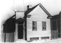
House (freedman's cottage) on site affected by the construction of Interstate 26 (I-26). Address: 8 Brigade Street. Surveyor notations on back of photo: "Dkt.: 10.503. Property owner: Gussie Feldman, et al. Tract: 44-A. Station: 5905+00 Rt. & Lt. Date: Feb. 19, 1963. In R/W - Bought." [See collection description for explanation of surveyor notations.]