Newspaper printed for the civilian employees of the Charleston Naval Shipyard starting on January 6th 1961. This volume covers from January 6th 1961 to December 29rd 1961.
Photograph of eight members of Avery's class of 1931 reunited after thirty years at a classmate's wedding. All are dressed up and stand outside of a church.
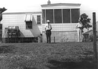
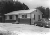
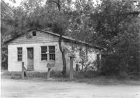
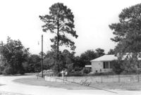
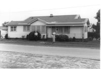
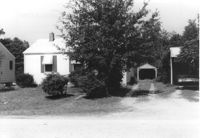
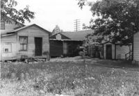
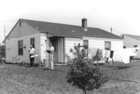
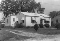
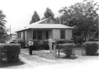
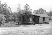
House on site affected by the construction of Interstate 26 (I-26). Building address number 197. Garage/shed at end of driveway. Surveyor notations on back of photo: "Dkt.: 10.480. Property owner: Geo. Smith, et al. Tract: 135. Station: 5654+50 Rt. Date: May 2, 1961. In R/W - Bought." [See collection description for explanation of surveyor notations.]
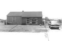
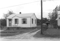
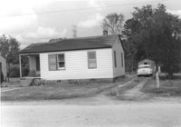
House on site affected by the construction of Interstate 26 (I-26). Building address number 189. Garage/shed at end of driveway. Surveyor notations on back of photo: "Dkt.: 10.480. Property owner: Elmer C. Waite. Tract: 131. Station: 5652+30 Rt. Date: May 2, 1961. In R/W - Bought." [See collection description for explanation of surveyor notations.]
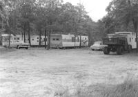
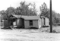
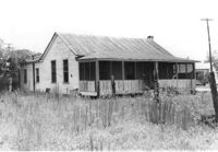
Trailers (trailer park?) on site affected by the construction of Interstate 26 (I-26). Surveyor notations on back of photo: "Dkt.: 10.480. Property owner: Williams Furniture Co., et al. Tract: 103-E. Station: 5580+80 Rt. (Line J). Date: May 2, 1961. Loss underground improvements." [See collection description for explanation of surveyor notations.]
House (corner view) on site affected by the construction of Interstate 26 (I-26). Garage/shed at end of driveway. Surveyor notations on back of photo: "Dkt.: 10.480. Property owner: R.R. Barwick. Tract: 137. Station: 5655+80 Rt. Date: May 2, 1961. In R/W - Bought." [See collection description for explanation of surveyor notations.]
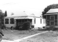
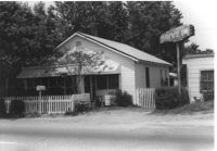
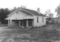
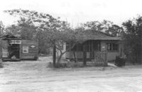
House in dilapidated condition on site affected by the construction of Interstate 26 (I-26). Outbuilding, possible once a market, in background. Has signs for Royal Crown Cola and Pepsi-Cola on front. Surveyor notations on back of photo: "Dkt.: 10.480. Property owner: J.L. Spencer, et al. Tract: 50. Station: 5515+30 Lt. Date: May 2, 1961. In R/W - Bought." [See collection description for explanation of surveyor notations.]
Corner of house, with view of shed at rear of property, on site affected by the construction of Interstate 26 (I-26). Possibly on Rivers Avenue. Surveyor notations on back of photo: "Dkt.: 10.486. Property owner: Mrs. Ida K. Hill. Tract: 16. Station: 12+00 Rt. (Main Line). Date: May 30, 1961. In R/W - Bought." [See collection description for explanation of surveyor notations.]
Side view of house (duplex) on site affected by the construction of Interstate 26 (I-26). Building address numbers 1809A and 1809B. Possibly on Rivers Avenue. Surveyor notations on back of photo: "Dkt.: 10.486. Property owner: Joseph S. & Vivian G. Walsh. Tract: 14. Station: 12+00 (Line D). Date: May 30, 1961. In R/W - Bought." [See collection description for explanation of surveyor notations.]
House (duplex) on site affected by the construction of Interstate 26 (I-26). Building address numbers 1809A and 1809B. Possibly on Rivers Avenue. Surveyor notations on back of photo: "Dkt.: 10.486. Property owner: Joseph S. & Vivian G. Walsh. Tract: 14. Station: 12+00 (Line D). Date: May 30, 1961. In R/W - Bought." [See collection description for explanation of surveyor notations.]
House (rear view) on site affected by the construction of Interstate 26 (I-26). Building address number 1812. Possibly on Rivers Avenue. Surveyor notations on back of photo: "Dkt.: 10.486. Property owner: J.A. Livingston. Tract: 15. Station: 11+80 Lt. Date: May 30, 1961. In R/W - Bought." [See collection description for explanation of surveyor notations.]
House on site affected by the construction of Interstate 26 (I-26). Building address number 1806. Possibly on Rivers Avenue. Surveyor notations on back of photo: "Dkt.: 10.486. Property owner: Cleve G. Murray. Tract: 12. Station: 10+90 Lt. Date: May 30, 1961. In R/W - Bought." [See collection description for explanation of surveyor notations.]
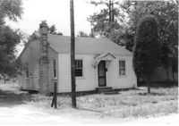
House on site affected by the construction of Interstate 26 (I-26). Building address number 183. Garage/shed at end of driveway. Surveyor notations on back of photo: "Dkt.: 10.480. Property owner: D.M. Swails, et al. Tract: 128. Station: 5650+40 Rt. Date: May 2, 1961. In R/W - Bought." [See collection description for explanation of surveyor notations.]
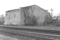
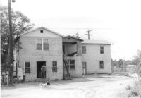
Building by railroad tracks, on site affected by the construction of Interstate 26 (I-26). Surveyor notations on back of photo: "Dkt.: 10.480. Property owner: Raymond O. Dion. Tract: 107. Station: 5630± to 5636±. Date: May 2, 1961. To be demolished." [See collection description for explanation of surveyor notations.]
House on site affected by the construction of Interstate 26 (I-26). Surveyor notations on back of photo: "Dkt.: 10.480. Property owner: Preston H. Mundy. Tract: 104. Station: 5574+70 Lt. (Line J). Date: May 2, 1961. In R/W - Bought." [See collection description for explanation of surveyor notations.]
House on site affected by the construction of Interstate 26 (I-26). Possibly on Rivers Avenue. Surveyor notations on back of photo: "Dkt.: 10.486. Property owner: John W. Faulkner. Tract: 3. Station: 6+40 Lt. Date: May 30, 1961. Proximity." [See collection description for explanation of surveyor notations.]
House on site affected by the construction of Interstate 26 (I-26). Surveyor notations on back of photo: "Dkt.: 10.480. Property owner: Paul W. Wall. Tract: 158. Station: 5670+20 Rt. Date: May 1, 1961. In R/W - Bought." [See collection description for explanation of surveyor notations.]
House on site affected by the construction of Interstate 26 (I-26). Surveyor notations on back of photo: "Dkt.: 10.480. Property owner: G.B. Lewis. Tract: 140. Station: 5657+60 Rt. Date: May 1, 1961. In R/W - Bought." [See collection description for explanation of surveyor notations.]
House or apartment building on site affected by the construction of Interstate 26 (I-26). Pepsi-Cola sign and mailbox with address number 164 next to building. Surveyor notations on back of photo: "Dkt.: 10.480. Property owner: Central McMillan, et al. Tract: 38. Station: 5508+40 Rt. Date: May 2, 1961. In R/W - Bought." [See collection description for explanation of surveyor notations.]
House in dilapidated condition and adjacent structure on site affected by the construction of Interstate 26 (I-26). Building address number 316. Surveyor notations on back of photo: "Dkt.: 10.480. Property owner: Fred McMillian, et al. Tract: 41. Station: 5509+50 Lt. Date: May 2, 1961. In R/W - Bought." [See collection description for explanation of surveyor notations.]
House in dilapidated condition and adjacent structure on site affected by the construction of Interstate 26 (I-26). Building address number 316. Surveyor notations on back of photo: "Dkt.: 10.480. Property owner: Fred McMillian, et al. Tract: 41. Station: 5509+50 Lt. Date: May 2, 1961. In R/W - Bought." [See collection description for explanation of surveyor notations.]
House on site affected by the construction of Interstate 26 (I-26). Driveway leads to garage/shed. Surveyor notations on back of photo: "Dkt.: 10.480. Property owner: James W. Sadler. Tract: 123. Station: 5647+60 Lt. Date: May 1, 1961. In R/W - Bought." [See collection description for explanation of surveyor notations.]
House on site affected by the construction of Interstate 26 (I-26). Building address number 1800. Possibly on Rivers Avenue. Surveyor notations on back of photo: "Dkt.: 10.486. Property owner: G.P. Parris, Est. Tract: 6. Station: 9+50 Lt. Date: May 30, 1961. In R/W - Bought." [See collection description for explanation of surveyor notations.]
House (rear view) on site affected by the construction of Interstate 26 (I-26). Possibly on Rivers Avenue. Surveyor notations on back of photo: "Dkt.: 10.486. Property owner: James M. Miller. Tract: 8. Station: 10+45 CL (Line D). Date: May 30, 1961. In R/W - Bought." [See collection description for explanation of surveyor notations.]
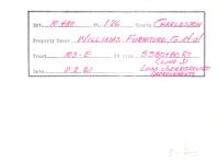
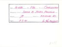
Example of information written on back of photograph: Docket Number, Route, County, Property Owner, Tract, Station, Date, and added note pertaining to right-of-way.
Example of information written on back of photograph: Docket Number, Route, County, Property Owner, Tract, Station, Date, and added note pertaining to right-of-way.
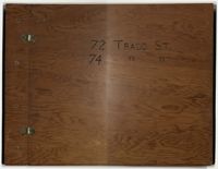
Compilation of original deeds, titles, and other documents related to the transfer, sale, and ownership of the double tenement at 72-74 Tradd Street, known as the Fotheringham-McNeil Tenements. Documents span from 1765 to 1961, likely representing the entire history of the ownership of the double tenement throughout that time period. Also includes blueprints and photographs. (NOTE: Fotheringham has also been spelled Fotheringham.)
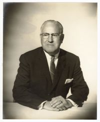
A photo of Pearlstine posing with his hands folded on a table. Notes on the back indicate this photo was taken at Furchgott Studio in November of 1961.
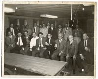
A group photo of the staff of Pearlstine Distributors. Notes on the back indicate the picture was taken in 1961 at Waccendaw Lakes Fish Camp at WCBD Channel 2.
University of Wisconsin Rural CAP Training Program course material entitled, "Group Sensitivity Training," excerpted from Carl Rogers', "This is me," in "On Becoming a Person."
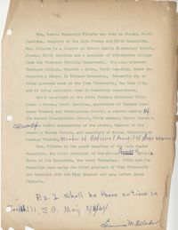
Correspondence from Bernice V. Robinson to the Highlander Staff regarding the Report of the Training Leaders for Citizenship Schools, July 17 to 23, 1961.
House (rear view) on site affected by the construction of Interstate 26 (I-26). [Building address number 145.] Surveyor notations on back of photo: "Dkt.: 10.480. Property owner: Jerome M. Williams. Tract: 270. Station: 5724+10 Lt. (Line C). Date: May 31, 1961. Proximity." [See collection description for explanation of surveyor notations.]
House on site affected by the construction of Interstate 26 (I-26). Possibly on Rivers Avenue. Surveyor notations on back of photo: "Dkt.: 10.486. Property owner: Ernest E. & Nolie C. Grooms. Williams Furniture Corp. Tract: 41. Station: 29+40 Lt. Date: May 30, 1961. In R/W - Bought." [See collection description for explanation of surveyor notations.]
House (corner view, rear) on site affected by the construction of Interstate 26 (I-26). Possibly on Rivers Avenue. Surveyor notations on back of photo: "Dkt.: 10.486. Property owner: Mrs. Mertice S. Greenhill. Tract: 26. Station: 8+50 Lt. (Line E). Date: May 30, 1961. In R/W - Bought." [See collection description for explanation of surveyor notations.]
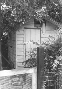
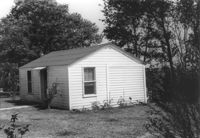
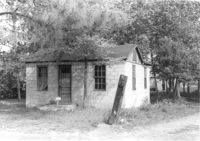
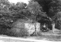
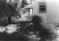
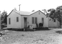
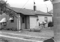
Shed on site affected by the construction of Interstate 26 (I-26). Surveyor notations on back of photo: "Dkt.: 10.480. Property owner: C.H. & Elise V. Meidburg. Tract: 249. Station: 5705+80 Lt. Date: May 31, 1961. In R/W - Bought." [See collection description for explanation of surveyor notations.]
House (corner view, rear) on site affected by the construction of Interstate 26 (I-26). [Building address number 131). Surveyor notations on back of photo: "Dkt.: 10.480. Property owner: Minnie L. Geiger. Tract: 277. Station: 5725+40 Rt. (Line C). Date: May 31, 1961. In R/W - Bought." [See collection description for explanation of surveyor notations.]
House on site affected by the construction of Interstate 26 (I-26). Building address number 4800. Possibly on Rivers Avenue. Surveyor notations on back of photo: "Dkt.: 10.486. Property owner: Redding F. Moore. Tract: 23, 24, 25. Station: 15+70 Lt. (Line C). Date: May 30, 1961. In R/W to be moved." [See collection description for explanation of surveyor notations.]
House on site affected by the construction of Interstate 26 (I-26). Building address number 131. Surveyor notations on back of photo: "Dkt.: 10.480. Property owner: Minnie L. Geiger. Tract: 277. Station: 5725+40 Rt. (Line C). Date: May 31, 1961. In R/W - Bought." [See collection description for explanation of surveyor notations.]
Guesthouse? on site affected by the construction of Interstate 26 (I-26). Surveyor notations on back of photo: "Dkt.: 10.480. Property owner: Jessie L. & Doris S. Bercaw. Tract: 272. Station: 5724+85 Rt. (Line C). Date: May 31, 1961. In R/W - Bought." [See collection description for explanation of surveyor notations.]
House on site affected by the construction of Interstate 26 (I-26). Surveyor notations on back of photo: "Dkt.: 10.480. Property owner: Mrs. Sarah Elise P. Ford Thompson. Tract: 260. Station: 5712+20 Lt. Date: May 31, 1961. In R/W - Bought." [See collection description for explanation of surveyor notations.]
House on site affected by the construction of Interstate 26 (I-26). Surveyor notations on back of photo: "Dkt.: 10.480. Property owner: Rebecca R. Wiggins. Tract: 16. Station: 5503+30 Rt. Date: May 2, 1961. In R/W - Bought." [See collection description for explanation of surveyor notations.]
House on site affected by the construction of Interstate 26 (I-26). Surveyor notations on back of photo: "Dkt.: 10.480. Property owner: Central McMillan. Tract: 17. Station: 5503+70 Rt. Date: May 2, 1961. In R/W - Bought." [See collection description for explanation of surveyor notations.]
House on site affected by the construction of Interstate 26 (I-26). Surveyor notations on back of photo: "Dkt.: 10.480. Property owner: John Chaplin. Tract: 18. Station: 5503+90 Rt. Date: May 2, 1961. In R/W - Bought." [See collection description for explanation of surveyor notations.]
House on site affected by the construction of Interstate 26 (I-26). Surveyor notations on back of photo: "Dkt.: 10.480. Property owner: Paul Allen. Tract: 21. Station: 5503+80 Lt. Date: May 2, 1961. In R/W - Bought." [See collection description for explanation of surveyor notations.]
House on site affected by the construction of Interstate 26 (I-26). Building address number 107. Possibly on Rivers Avenue. Surveyor notations on back of photo: "Dkt.: 10.486. Property owner: G.F. & Beatrice C. Butler. Tract: 27. Station: 7+50 (Line E). Date: May 30, 1961. Proximity." [See collection description for explanation of surveyor notations.]
House (rear view) on site affected by the construction of Interstate 26 (I-26). Possibly on Rivers Avenue. Surveyor notations on back of photo: "Dkt.: 10.486. Property owner: M.V. & Beatrice Barrineau. Tract: 25-A. Station: 16+00 Rt. (Line C). Date: May 30, 1961. Bought." [See collection description for explanation of surveyor notations.]
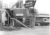
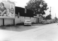
Restaurant building on site affected by the construction of Interstate 26 (I-26). Stairway and sign for Buffet Lunch in foreground. Portion of neon sign: Charcoal Broiler hangs over a phone booth. Possibly on Rivers Avenue. Surveyor notations on back of photo: "Dkt.: 10.486. Property owner: John Marcotsis, Trustee. Tract: 32. Station: 3+00 Rt. (Line F). Date: May 30, 1961. Steps to be moved. Proximity." [See collection description for explanation of surveyor notations.]
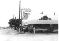
Marine Center (boat sales) on site affected by the construction of Interstate 26 (I-26). Address 4752 Rivers Avenue. View of street corner. C & R Motors in background. Possibly on Rivers Avenue. Surveyor notations on back of photo: "Dkt.: 10.486. Property owner: C.W. Keller. Tract: 33. Station: 2+75 Lt. (Line E). Date: May 30, 1961. Sign to be moved." [See collection description for explanation of surveyor notations.]
House on site affected by the construction of Interstate 26 (I-26). Neon sign for a Drive In (__MANER'S) (name partly illegible) in front, at right of photo. Possibly on Rivers Avenue. Surveyor notations on back of photo: "Dkt.: 10.486. Property owner: M.V. & Beatrice Barrineau. Tract: 25-A. Station: 16+00 Rt. (Line C). Date: May 30, 1961. Bought." [See collection description for explanation of surveyor notations.]
House (corner view, rear) on site affected by the construction of Interstate 26 (I-26). Surveyor notations on back of photo: "Dkt.: 10.480. Property owner: Willie M. Burbage. Tract: 271. Station: 5724+60 Lt. (Line C) Date: May 31, 1961. Proximity." [See collection description for explanation of surveyor notations.]
House/office (side view) on site affected by the construction of Interstate 26 (I-26). Signs "Open for Inspection" and posted office hours on front. Possibly on Rivers Avenue. Surveyor notations on back of photo: "Dkt.: 10.486. Property owner: Otis R. Burbage. Tract: 22 & 34. Station: 14+80 Rt. Date: May 30, 1961. In R/W to be moved." [See collection description for explanation of surveyor notations.]
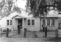
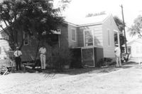
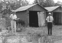
Rear view of house on site affected by the construction of Interstate 26 (I-26). Possibly on Rivers Avenue. Two DOT employees in foreground. Surveyor notations on back of photo: "Dkt.: 10.486. Property owner: Robert E. Holman. Tract: 35. Station: 11+50 Lt. (Line D). Date: May 30, 1961. Proximity." [See collection description for explanation of surveyor notations.]
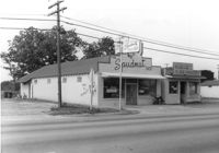
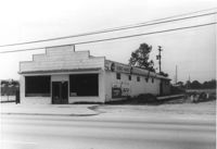
The Spudnut Shop [3646 Dorchester Road], on site affected by the construction of Interstate 26 (I-26). Front facade has stepped parapet. Neighboring building, Pick & Pay Grocery, also in photo. Surveyor notations on back of photo: "Dkt.: 10.480. Property owner: John C. Gelegotes, et al. Tract: 164. Station: 5681+50 on CL. Date: May 30, 1961. In R/W - Bought." [See collection description for explanation of surveyor notations.]
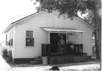
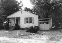
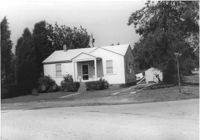
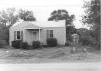
House on Dorchester Road, on site affected by the construction of Interstate 26 (I-26). Building address number 7. Surveyor notations on back of photo: "Dkt.: 10.480. Property owner: Fred M. Skipper. Tract: 179. Station: 132+90 Rt. (Route 642) [Dorchester Road]. Date: May 30, 1961. In R/W - Bought." [See collection description for explanation of surveyor notations.]
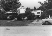
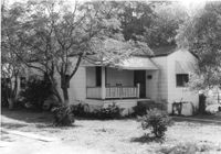
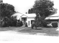
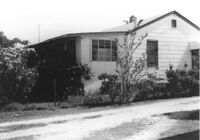
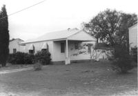
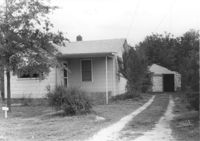
House on site affected by the construction of Interstate 26 (I-26). Partially obscured by trees. Garage (2-story) at end of driveway. Surveyor notations on back of photo: "Dkt.: 10.480. Property owner: Eugene J. Poteat. Tract: 201. Station: 5689+50 Lt. Date: May 31, 1961. In R/W - Bought." [See collection description for explanation of surveyor notations.]
House on Dorchester Road, on site affected by the construction of Interstate 26 (I-26). Building address number 7. Surveyor notations on back of photo: "Dkt.: 10.480. Property owner: Fred M. Skipper. Tract: 179. Station: 132+90 Rt. (Route 642) [Dorchester Road]. Date: May 30, 1961. In R/W - Bought." [See collection description for explanation of surveyor notations.]
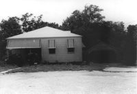
House at curve in road, on site affected by the construction of Interstate 26 (I-26). Surveyor notations on back of photo: "Dkt.: 10.480. Property owner: Mrs. Hazel McSherley Barton. Tract: 185. Station: 5684+65± Rt. (Line D). Date: May 31, 1961. Damage to fence and loss of pine tree." [See collection description for explanation of surveyor notations.]
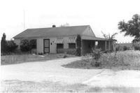
House on corner of Harvey Avenue, on site affected by the construction of Interstate 26 (I-26). Street sign for Harvey Ave. at right. Surveyor notations on back of photo: "Dkt.: 10.480. Property owner: Renkin Finance Co. Tract: 188. Station: 5686+00 Lt. Date: May 31, 1961. In R/W - Bought." [See collection description for explanation of surveyor notations.]
House on Dorchester Road, on site affected by the construction of Interstate 26 (I-26). Surveyor notations on back of photo: "Dkt.: 10.480. Property owner: Mrs. Margaret H. Patterson. Tract: 181. Station: 134+00 (Rt. (Route 642) [Dorchester Road]. Date: May 31, 1961. In R/W - Bought." [See collection description for explanation of surveyor notations.]
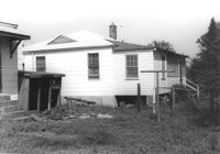
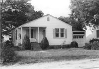
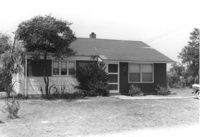
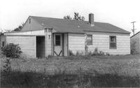
House on site affected by the construction of Interstate 26 (I-26). Partially obscured by trees. Surveyor notations on back of photo: "Dkt.: 10.480. Property owner: Sallie Mae Penninger. Tract: 198. Station: 5688+95 Lt. Date: May 31, 1961. In R/W - Bought." [See collection description for explanation of surveyor notations.]
Property and structure (shed?) on Dorchester Road, on site affected by the construction of Interstate 26 (I-26). Surveyor notations on back of photo: "Dkt.: 10.480. Property owner: Mrs. Dorothy V. Bartee. Tract: 178. Station: 132+42 Rt. (Route 642) [Dorchester Road]. Date: May 30, 1961. In R/W - Bought." [See collection description for explanation of surveyor notations.]
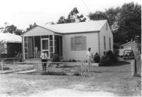
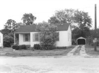
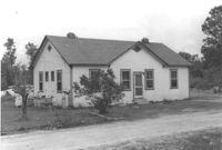
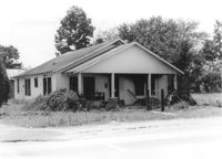
House on site affected by the construction of Interstate 26 (I-26). Building address number 191. Driveway leads to garage/shed. Surveyor notations on back of photo: "Dkt.: 10.480. Property owner: John S. Singleton. Tract: 132. Station: 5652+80 Rt. Date: May 1, 1961. In R/W - Bought." [See collection description for explanation of surveyor notations.]
House on site affected by the construction of Interstate 26 (I-26). Building address number 109. Surveyor notations on back of photo: "Dkt.: 10.480. Property owner: Tujax, Inc. Tract: 283. Station: 5732+70 Lt. (Line B). Date: May 30, 1961. In R/W - Bought." [See collection description for explanation of surveyor notations.]
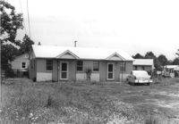
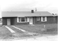
House on site affected by the construction of Interstate 26 (I-26). Building address number 209. Surveyor notations on back of photo: "Dkt.: 10.480. Property owner: Donald L. Gibson, et al. Tract: 141. Station: 5658+30 Rt. Date: May 2, 1961. In R/W - Bought." [See collection description for explanation of surveyor notations.]
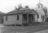
House on site affected by the construction of Interstate 26 (I-26). Neighboring church in background. Surveyor notations on back of photo: "Dkt.: 10.480. Property owner: Joseph Perry. Tract: 35. Station: 5507+40 Lt. Date: May 1, 1961. In R/W - Bought." [See collection description for explanation of surveyor notations.]
House (rear view) on site affected by the construction of Interstate 26 (I-26). Surveyor notations on back of photo: "Dkt.: 10.480. Property owner: Eugene J. Poteat. Tract: 201. Station: 5689+50 Lt. Date: May 31, 1961. In R/W - Bought." [See collection description for explanation of surveyor notations.]
House (rear view) on site affected by the construction of Interstate 26 (I-26). Surveyor notations on back of photo: "Dkt.: 10.480. Property owner: Joseph A. Elsey. Tract: 200. Station: 5689+70 Rt. Date: May 31, 1961. In R/W - Bought." [See collection description for explanation of surveyor notations.]
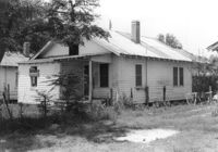
House on site affected by the construction of Interstate 26 (I-26). Surveyor notations on back of photo: "Dkt.: 10.480. Property owner: Crider O. Murray. Tract: 202. Station: 5689+90 Lt. Date: May 31, 1961. In R/W - Bought." [See collection description for explanation of surveyor notations.]
House on site affected by the construction of Interstate 26 (I-26). Surveyor notations on back of photo: "Dkt.: 10.480. Property owner: Joseph A. Elsey. Tract: 200. Station: 5689+70 Rt. Date: May 31, 1961. In R/W - Bought." [See collection description for explanation of surveyor notations.]
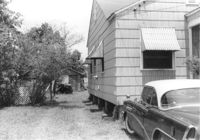
Two-story garage (corner view) on site affected by the construction of Interstate 26 (I-26). Surveyor notations on back of photo: "Dkt.: 10.480. Property owner: Eugene J. Poteat. Tract: 201. Station: 5689+50 Lt. Date: May 31, 1961. In R/W - Bought." [See collection description for explanation of surveyor notations.]
House on site affected by the construction of Interstate 26 (I-26). Possibly on Rivers Avenue. Surveyor notations on back of photo: "Dkt.: 10.486. Property owner: Hubert W. Keller. Tract: 29. Station: 6+80 (Line F). Date: May 30, 1961. Proximity." [See collection description for explanation of surveyor notations.]
Storage shed on site affected by the construction of Interstate 26 (I-26). Possibly on Rivers Avenue. Surveyor notations on back of photo: "Dkt.: 10.486. Property owner: Ida K. Hill. Tract: 37. Station: 12+30 Lt. (Line D). Date: May 30, 1961. In R/W - Bought." [See collection description for explanation of surveyor notations.]
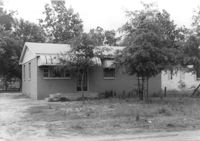
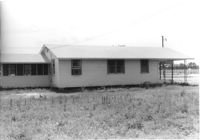
House (corner view, rear) on site affected by the construction of Interstate 26 (I-26). Building address number 18. Surveyor notations on back of photo: "Dkt.: 10.480. Property owner: Harry Morse Construction Co. Tract: 196. Station: 5688+00 Lt. Date: May 31, 1961. In R/W - Bought." [See collection description for explanation of surveyor notations.]
House (side view) on site affected by the construction of Interstate 26 (I-26). Partially obscured by trees. Surveyor notations on back of photo: "Dkt.: 10.480. Property owner: Sallie Mae Penninger. Tract: 198. Station: 5688+95 Lt. Date: May 31, 1961. In R/W - Bought." [See collection description for explanation of surveyor notations.]
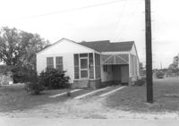
House on site affected by the construction of Interstate 26 (I-26). Garage/shed at end of driveway. Surveyor notations on back of photo: "Dkt.: 10.480. Property owner: Herbert Jones. Tract: 192. Station: 5687+00 Lt. Date: May 31, 1961. In R/W - Bought." [See collection description for explanation of surveyor notations.]
House on site affected by the construction of Interstate 26 (I-26). Neighboring (rear) houses and structures in background. Surveyor notations on back of photo: "Dkt.: 10.480. Property owner: Rochell Dinkins, et al. Tract: 59. Station: 5516+80 Lt. Date: May 1, 1961. In R/W - Bought." [See collection description for explanation of surveyor notations.]
Dorchester Electric Service (side view) on site affected by the construction of Interstate 26 (I-26). Building address number 3640 [possibly Dorchester Road]. Billboard for Swift's Premium Meats for Babies on side of building. Surveyor notations on back of photo: "Dkt.: 10.480. Property owner: Laura B. Beaufort. Tract: 167. Station: 5681+40 Lt. Date: May 30, 1961. In R/W - Bought." [See collection description for explanation of surveyor notations.]
Terrace Market on site affected by the construction of Interstate 26 (I-26). Building is closed. Sunbeam Bread sign on side of building. Front facade has stepped parapet. Surveyor notations on back of photo: "Dkt.: 10.480. Property owner: John C. Gelegotes, et al. Tract: 163. Station: 5681+00 Rt. Date: May 30, 1961. In R/W - Bought." [See collection description for explanation of surveyor notations.]
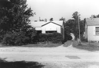
Rear view of dwellings and other structures on site affected by the construction of Interstate 26 (I-26). Sign for The Spudnut Shop in mid-background. Surveyor notations on back of photo: "Dkt.: 10.480. Property owner: Arlene Phillips, Est. Tract: 165. Station: 5680+75 Lt. Date: May 30, 1961. In R/W - Bought." [See collection description for explanation of surveyor notations.]
House (corner view, rear) on site affected by the construction of Interstate 26 (I-26). Building address number 33. Surveyor notations on back of photo: "Dkt.: 10.480. Property owner: Jesse L. Kennedy. Tract: 290. Station: 5738+85 Rt. (Line B). Date: May 30, 1961. In R/W - Bought." [See collection description for explanation of surveyor notations.]
House (rear view) on site affected by the construction of Interstate 26 (I-26). Building address number 35. Surveyor notations on back of photo: "Dkt.: 10.480. Property owner: Mrs. Helen S. Shuler. Tract: 291. Station: 5738+50 CL. Date: May 30, 1961. In R/W - Bought." [See collection description for explanation of surveyor notations.]
House on site affected by the construction of Interstate 26 (I-26). Building address number 35. Surveyor notations on back of photo: "Dkt.: 10.480. Property owner: Mrs. Helen S. Shuler. Tract: 291. Station: 5738+50 CL Main Line. Date: May 30, 1961. In R/W - Bought." [See collection description for explanation of surveyor notations.]
House (corner view, rear) on site affected by the construction of Interstate 26 (I-26). Surveyor notations on back of photo: "Dkt.: 10.480. Property owner: Mrs. Evelyn R. King. Tract: 288. Station: 5738+80 Lt. (Line B). Date: May 30, 1961. Proximity." [See collection description for explanation of surveyor notations.]
House on site affected by the construction of Interstate 26 (I-26). Surveyor notations on back of photo: "Dkt.: 10.480. Property owner: Mrs. Evelyn R. King. Tract: 288. Station: 5738+80 Lt. (Line B). Date: May 30, 1961. Proximity." [See collection description for explanation of surveyor notations.]


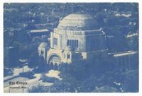
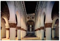
![[Ben Ezra Synagogue, Cairo]](https://iiif.library.cofc.edu/iiif/2/47345/full/200,/0/default.jpg)