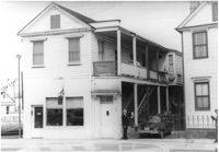
Building with ground-story business, Sunset Memorial Gardens, and second-story residence, on site affected by the construction of Interstate 26 (I-26). Address: 642 King Street. Surveyor notations on back of photo: "Dkt.: 10.517. Property owner: N.W. Cabell. Tract: 80. 29+00 Rt. Northbound Lane. Date: March 5, 1963. In R/W - Bought." [See collection description for explanation of surveyor notations.]
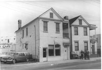
Building with ground-story business, Sunset Memorial Gardens, and second-story residence, on site affected by the construction of Interstate 26 (I-26). Address: 642 King Street and its neighbor, 640 King Street. Next door to McKethan Oldsmobile. Surveyor notations on back of photo: "Dkt.: 10.517. Property owner: N.W. Cabell. Tract: 80. 29+00 Rt. Northbound Lane. Date: March 5, 1963. In R/W - Bought." [See collection description for explanation of surveyor notations.]
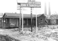
Lot on site affected by the construction of the Crosstown. Address: 32 Lee Street (south side of street). Sign for John P. Tankersley Insurance, East of Cooper. House/structure abuts lot; posted sign indicates it is closed by the Board of Health. Industrial smokestacks in background (Cigar Factory?). Surveyor notations on back of photo: "Dkt.: 10.518. Property owner: Clifton Iron. Tract: 68. Station: 52+35 Lt. N.B. lane Route 17. Date: Mar. 7, 1963. In R/W - Bought." [See collection description for explanation of surveyor notations.]
Right of way--South Carolina--Charleston County, Highway planning--South Carolina--Charleston County, Commercial buildings--South Carolina--Charleston County, Vernacular architecture--South Carolina--Charleston County, Lost architecture--South Carolina--Charleston County, Dwellings--South Carolina--Charleston County✖[remove]3
Charleston County (S.C.)--Buildings, structures, etc.✖[remove]3