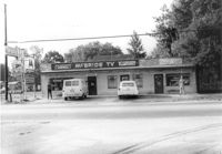
McBride TV and Roy's Barber Shop, on site affected by the widening of State Road 13 (Remount Road). Surveyor notations on back of photo: "Dkt.: 10.562. Property owner: Pearl T. Leiderman. Tract: 39. Date: Jul. 19, 1967." [See collection description for explanation of surveyor notations.]
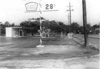
Kayo gas station, on site affected by the widening of State Road 13 (Remount Road). Surveyor notations on back of photo: "Dkt.: 10.562. Property owner: S.R. Hill - K.O. Station. Tract: 66. Date: Jul. 19, 1967." [See collection description for explanation of surveyor notations.]
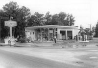
Atlantic gas station, on site affected by the widening of State Road 13 (Remount Road). Surveyor notations on back of photo: "Dkt.: 10.562. Property owner: Atlantic Refining Co. Tract: 37. Date: Jul. 19, 1967." [See collection description for explanation of surveyor notations.]
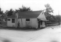
House on site affected by the widening of State Road 13 (Remount Road). Surveyor notations on back of photo: "Dkt.: 10.562. Property owner: Mrs. J.L. McFadyen. Tract: 69. Date: Jul. 19, 1967." [See collection description for explanation of surveyor notations.]
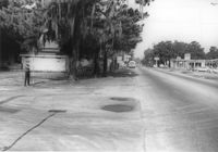
Site affected by the widening of State Road 13 (Remount Road). Surveyor notations on back of photo: "Dkt.: 10.562. Property owner: Barbara Pringle. Tract: 43. Date: Jul. 19, 1967." [See collection description for explanation of surveyor notations.]
Texaco gas station, on site affected by the widening of State Road 13 (Remount Road). Neighboring Gulf gas Station: in background. Surveyor notations on back of photo: "Dkt.: 10.562. Property owner: W.L. Dyches, et al. Tract: 23. Date: Jul. 12, 1967." [See collection description for explanation of surveyor notations.]
Leiderman's Sky Way Cafe, on site affected by the widening of Route 171 (Folly Road). Front facade has stepped parapet. "Dkt.: 10.562. Property owner: H.W. Leiderman. Tract: 41. Date: Jul. 19, 1967." [See collection description for explanation of surveyor notations.]
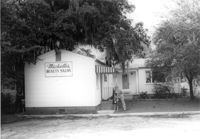
Michelle's Beauty Salon, on site affected by the widening of State Road 13 (Remount Road). Surveyor notations on back of photo: "Dkt.: 10.562. Property owner: Jerry Gray. Tract: 120. Date: Jul. 19, 1967." [See collection description for explanation of surveyor notations.]
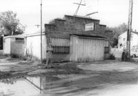
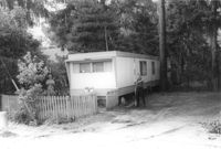
Mobile home on site affected by the widening of State Road 13 (Remount Road). Surveyor notations on back of photo: "Dkt.: 10.562. Property owner: Alline S. Crum. Tract: 139. Date: Jul. 19, 1967." [See collection description for explanation of surveyor notations.]
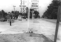
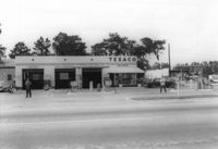
Texaco gas station, on site affected by the widening of State Road 13 (Remount Road). Surveyor notations on back of photo: "Dkt.: 10.562. Property owner: W.L. Dyches, et al. Tract: 23. Date: Jul. 12, 1967." [See collection description for explanation of surveyor notations.]
Limit your search
SCDOT Photographs: Properties in the Right-of-Way✖[remove]81