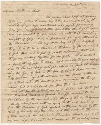
Writing to Edgar B. Day, William H. W. Barnwell discusses his religious thoughts including the notion that freeing slaves from the bondage of sin is more important than freedom itself. April 24, 1832.
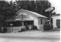
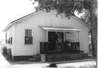
House on site affected by the construction of Interstate 26 (I-26). Neon sign for a Drive In (__MANER'S) (name partly illegible) in front, at right of photo. Possibly on Rivers Avenue. Surveyor notations on back of photo: "Dkt.: 10.486. Property owner: M.V. & Beatrice Barrineau. Tract: 25-A. Station: 16+00 Rt. (Line C). Date: May 30, 1961. Bought." [See collection description for explanation of surveyor notations.]
House (rear view) on site affected by the construction of Interstate 26 (I-26). Possibly on Rivers Avenue. Surveyor notations on back of photo: "Dkt.: 10.486. Property owner: M.V. & Beatrice Barrineau. Tract: 25-A. Station: 16+00 Rt. (Line C). Date: May 30, 1961. Bought." [See collection description for explanation of surveyor notations.]
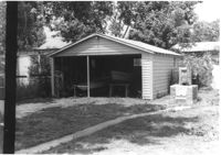
Garage at end of driveway, on site affected by the construction of Interstate 26 (I-26). Possibly on Rivers Avenue. Surveyor notations on back of photo: "Dkt.: 10.486. Property owner: M.V. & Beatrice Barrineau. Tract: 25-A. Station: 15+35 Rt. (Line C). Date: May 30, 1961. Bought." [See collection description for explanation of surveyor notations.]
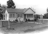
House on site affected by the construction of Interstate 26 (I-26). Possibly on Rivers Avenue. Surveyor notations on back of photo: "Dkt.: 10.486. Property owner: Mrs. Mertice S. Greenhill. Tract: 26. Station: 8+50 Lt. (Line E). Date: May 30, 1961. In R/W - Bought." [See collection description for explanation of surveyor notations.]
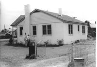
House (corner view, rear) on site affected by the construction of Interstate 26 (I-26). Possibly on Rivers Avenue. Surveyor notations on back of photo: "Dkt.: 10.486. Property owner: Mrs. Mertice S. Greenhill. Tract: 26. Station: 8+50 Lt. (Line E). Date: May 30, 1961. In R/W - Bought." [See collection description for explanation of surveyor notations.]
House (corner view, rear) on site affected by the construction of Interstate 26 (I-26). Possibly on Rivers Avenue. Surveyor notations on back of photo: "Dkt.: 10.486. Property owner: Mrs. Mertice S. Greenhill. Tract: 26. Station: 8+50 Lt. (Line E). Date: May 30, 1961. In R/W - Bought." [See collection description for explanation of surveyor notations.]
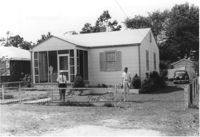
House on site affected by the construction of Interstate 26 (I-26). Building address number 107. Possibly on Rivers Avenue. Surveyor notations on back of photo: "Dkt.: 10.486. Property owner: G.F. & Beatrice C. Butler. Tract: 27. Station: 7+50 (Line E). Date: May 30, 1961. Proximity." [See collection description for explanation of surveyor notations.]