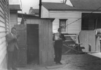
House (rear view) on site affected by the construction of the Crosstown. Address: 72 Cooper Street. Outhouse in foreground. Surveyor notations on back of photo: "Dkt.: 10.518. Property owner: Otis Williams. Tract: 22. Station: 40+55 Rt. N.B. lane Route 17. Date: Mar. 6, 1963." [See collection description for explanation of surveyor notations.]
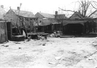
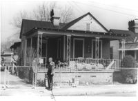
Lot on site affected by the construction of Interstate 26 (I-26). Address; 101 Romney Street. Surrounding houses and structures in background. Surveyor notations on back of photo: "Dkt.: 10.503. Property owner: Arthur Rembert. Tract: 92. Station: 5917+75 Lt. Date: Feb. 20, 1963. In R/W - Bought." [See collection description for explanation of surveyor notations.]
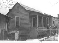
House (rear view) on site affected by the construction of Interstate 26 (I-26). Address: 99 Romney Street. Surveyor notations on back of photo: "Dkt.: 10.503. Property owner: Handy Felder, et al. Tract: 92-A. Station: 5916+95 Lt. Date: Feb. 20, 1963." [See collection description for explanation of surveyor notations.]
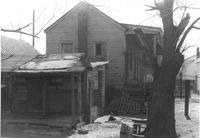
House on site affected by the construction of Interstate 26 (I-26). Address: 99 Romney Street. Surveyor notations on back of photo: "Dkt.: 10.503. Property owner: Handy Felder, et al. Tract: 92-A. Station: 5916+95 Lt. Date: Feb. 20, 1963." [See collection description for explanation of surveyor notations.]
House on site affected by the construction of Interstate 26 (I-26). Address: 14 Addison Street. Surveyor notations on back of photo: "Dkt.: 10.503. Property owner: Eddie Jenkins, et al. Tract: 92-B. Station: 5918+70 Lt. Date: Feb. 20, 1963. In R/W - Bought." [See collection description for explanation of surveyor notations.]
House (rear view) on site affected by the construction of Interstate 26 (I-26). Address: 14 Addison Street. Surveyor notations on back of photo: "Dkt.: 10.503. Property owner: Eddie Jenkins, et al. Tract: 92-B. Station: 5918+00 Lt. Date: Feb. 20, 1963. In R/W - Bought." [See collection description for explanation of surveyor notations.]
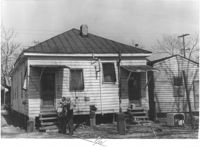
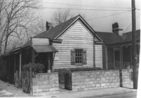
House (freedman's cottage?) on site affected by the construction of Interstate 26 (I-26). Address: 18 Addison Street. Surveyor notations on back of photo: "Dkt.: 10.503. Property owner: Hessie Alston. Tract: 93. Station: 5918+75 Lt. Date: Feb. 20, 1963. In R/W - Bought." [See collection description for explanation of surveyor notations.]
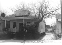
House (freedman's cottage?) on site affected by the construction of Interstate 26 (I-26). Address: 20 Addison Street. Surveyor notations on back of photo: "Dkt.: 10.503. Property owner: C.C. Scott. Tract: 94. Station: 5918+80 Lt. Date: Feb. 20, 1963. In R/W - Bought." [See collection description for explanation of surveyor notations.]
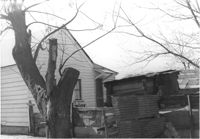
House (freedman's cottage?) and shed (rear view) on site affected by the construction of Interstate 26 (I-26). Address: 20 Addison Street. Surveyor notations on back of photo: "Dkt.: 10.503. Property owner: C.C. Scott. Tract: 94. Station: 5918+80 Lt. Date: Feb. 20, 1963. In R/W - Bought." [See collection description for explanation of surveyor notations.]
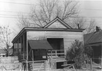
House (freedman's cottage) and shed (rear view) on site affected by the construction of Interstate 26 (I-26). Address: 24 Addison Street. Surveyor notations on back of photo: "Dkt.: 10.503. Property owner: Beatrice Scott. Tract: 93. Station: 5918+80 CL. Date: Feb. 20, 1963. In R/W - Bought." [See collection description for explanation of surveyor notations.]
Right of way--South Carolina--Charleston County, Highway planning--South Carolina--Charleston County, Vernacular architecture--South Carolina--Charleston County, Lost architecture--South Carolina--Charleston County, Dwellings--South Carolina--Charleston County✖[remove]1,563