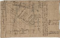
Plat of 500 acres belonging to George Mitchell in Colleton County near the Edisto River. Includes the outline of the property and the location of trees on the property line. Names associated with this plat are George Mitchell, Job Howe, and James Moore. Notable geographic locations include the Edisto River, Colleton County and St. Bartholomew's Parish.
Plat and abstracts of deeds belonging to James Laurence. Names associated with this plat include James Laurence, John Heyward, John Cole, Hogg, Loalan, Samuel Forsythe, William Forsythe, J. Schreiber, Henry Laurence, Harrison, Alexander Wright, Horry [?], and John Delayay.
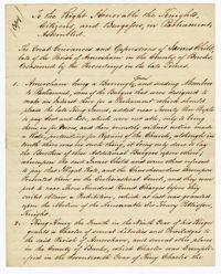
A copy of a petition to parliament titled "The Great Grievances and Oppression of James Child" in which the writer discusses "illegal rates" that were falsely presented as "repairs for the church" in Amersham. James Child and others refused to pay resulting in financial charges from the Ecclesiastical Church. The petition goes on to discuss charters for Amersham, James Child's imprisonment over his refusal to deliver an "Exemplification," and James Child being forced to abscond and sell his estate to pay off his debts. The second half discusses the various finances and property that James Child is giving to his son Isaac Child in South Carolina. Makes notations regarding Strawberry Plantation and Mepkin Plantation.
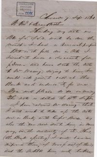
Francis Lynch writes to Bishop Patrick Lynch concerning his flourishing shoe business. Francis describes sending 1000 pair of shoes to the Confederate government in addition to those already provided to Col. L. M. Hatch. September 7, 1861. 3p.
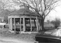
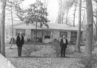
Gazebo, on site affected by the widening of Route 171 (Folly Road). Surveyor notations on back of photo: "Dkt.: 10.494. Property owner: Sophie Sabel, Est. Tract: 97. Station: 370+50 Lt. Date: Mar. 21, 1962. In R/W - Bought. [See collection description for explanation of surveyor notations.]
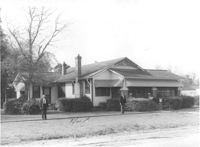
House on site affected by the widening of Route 171 (Folly Road). Surveyor notations on back of photo: "Dkt.: 10.494. Property owner: H.W. Halter, et al. Tract: 79. Station: 299+00 Rt. Date: Mar. 21, 1962. Proximity. [See collection description for explanation of surveyor notations.]
House on site affected by the widening of Route 171 (Folly Road). Surveyor notations on back of photo: "Dkt.: 10.494. Property owner: D.J. Byrd, et al. Tract: 73. Station: 280+60 Rt. Date: Mar. 21, 1962. Proximity. [See collection description for explanation of surveyor notations.]