Mary Wilkinson Memminger writes to her mother, chastising her for not writing. She also shares news from Charleston, including the news that her daughter Ellen has returned to Montpelier Institute, a school for girls in Georgia run by Bishop Stephen Elliott. She also informs her mother that they have met a distant cousin, a Dr. Borland, a sugar planter who lives in Louisiana.
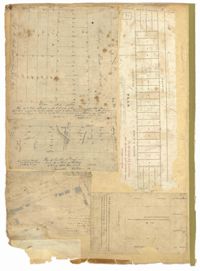
Page 104 of the City Engineer's Plat Book with one plat. The plat shows lots located between Moultrie Street and Cunnington Street. It also shows Lemon Street, Lee Street, Price Street, and Magnolia Street. It also shows a plat labelled "Artilery Society" and another plat labelled "Magnolia Cemetery."
Page 141 of the City Engineer's Plat Book with four plats. Plat 1 features a lot and structures located between Lynch Steet and the Ashley River, near Broad Street. It also shows Comings Creek, a pond, and a lot labelled "Clark & Steinmeyer." Plat 2 shows lots and structures located near the intersection of College Street and Calhoun Street. Plat 3 shows a lot and structures in "the City of Charleston in Ward No. 9." Plat 4 shows lots on and near Society Street, between Meeting Street and King Street.
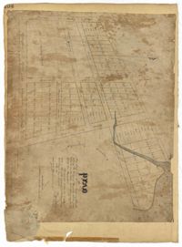
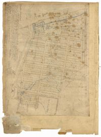
Page 220 of the City Engineer's Plat Book with one plat. The plat shows lots extending from the Ashley River, past Lucas Street. The plat also shows Doughty Street, Calhoun Street, President Street, U. S. Arsenal Square, and several structures.
Page 71 of the City Engineer's Plat Book with eight plats. Plat 1 shows lots and structures on a city block between Rutledge Street and Smith Street, and between Beaufain Street and Wentworth Street. Plat 2 shows lots located near the intersection of Moore Street and Meeting Street. Plat 3 shows lots and structures located near the intersection of King Street and Beaufain Street. Plat 4 shows lots and structures located on the east side of Coming Street. Plat 5 shows lots located on King Street, including a lot labelled "Unitarian Church property" and a stretch labelled "Unitarian Church Cemetery." Plat 6 shows lots located on King Street, and shows the "Old line of street." Plat 7 shows plots located on King Street. Plat 8 features a lot and buildings located on Spring Street, and shows how Rosemont Street is projected to cross that property.
Page 75 of the City Engineer's Plat Book with six plats. Plat 1 features lots located between Radcliffe Street and Calhoun Street, and between Smith Street and Rutledge Street. Plat 1 also shows Vanderhorst Street, Thomas Street, and Warren Street. Plat 2 shows lots located near Morris Street, between St. Philips Street and Coming Street. Plat 3 shows lots located near the intersection of Morris Street and Coming Street, including a lot labelled "Cemetery" and another lot labelled "Hebrew Cemetery." Plat 4 shows land located near Thomas Street, between Doughty Street and Hutson Street, and also labels a pond. Plat 5 shows lots located between Pine Street and Gadsden Creek. Plat 6 shows lots and some buildings located between Pinckney Street and Smith Street.
Page 84 of the City Engineer's Plat Book with five plats. Plat 1 shows lots located near Meeting Street, between Sheppard Street and Line Street. Plat 2 shows lots located along Race Street, between Rutledge Street and King Street. Plat 3 shows lots located between King Street and Meeting Street, and shows a stretch of Russell Street. Plat 4 features a lot and several buildings located near the intersection of Line Street and Meeting Street. Plat 4 also shows a label reading "The Rail Road" and another reading "Rail Road Company." Plat 5 features a lot on Hanover Street, and also shows a lot labelled "Cemetery."
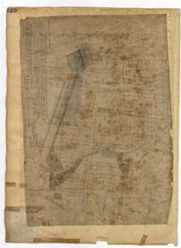
Page 80 of the City Engineer's Plat Book with one plat. The plat shows a plan for developing a stretch of land from the Ashley River towards President Street and Lucas Street, with a few lots and structures further east. The plat also shows a lot labelled "U. S. Arsenal Square," and a mill on the Ashley River.
Page 3 of the City Engineer's Plat Book with four plats. Plat 1 features lots at the intersection of Laurens Street and East Bay Street, and labels a section of salt marsh. Plat 2 shows plots at the intersection of East Bay Street and Hasell Street. Plat 3 features three lots of land and buildings on East Bay Street. Plat 4 shows a stretch of Pinckney Street between Bay Street and the Cooper River, including several lots.