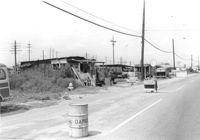
Lot on site affected by the construction of Interstate 26 (I-26). On Meeting Street/Meeting Street Road. View down street showing dilapidated structures on side of road, which is already a construction site. Surveyor notations on back of photo: "Dkt.: 10.510. Property owner: Geo. Fabian, Jr. Tract: 67. Station: 5801+60 - 5802+65 Lt. (Meeting Street). Date: Sept. 12, 1962. In R/W - Bought." [See collection description for explanation of surveyor notations.]
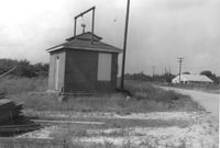
Small brick building, possibly a utility shed, on site affected by the construction of Interstate 26 (I-26). Coastal Motor Service (Photo 1307) in background, across the road. Surveyor notations on back of photo: "Dkt.: 10.490. Property owner: St. Phillips and St. Michael Pub. Service [St. Phillips and St. Michael Public Service]. Tract: 145. Station: 5877+67 Rt. 83' CL. Date: September 11, 1962. Moving item." [See collection description for explanation of surveyor notations.]
Limit your search
SCDOT Photographs: Properties in the Right-of-Way✖[remove]2
Right of way--South Carolina--Charleston County, Highway planning--South Carolina--Charleston County, Lost architecture--South Carolina--Charleston County✖[remove]2