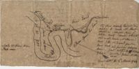
Copy of a tract of 127 acres in the marsh on the Ashepoo River belonging to Sarah McPherson. Little detail included in the plat. Names associated with this plat are Sarah McPherson, Willliam Spense, and Joshua McPherson. Notable geographic locations are the Ashepoo River, Deer Creek, Ladson, and Colleton County.
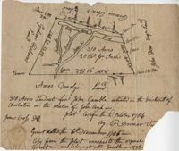
Plat contains 310 acres layer out for John Gamble granted November 6, 1706. Plat contains location of house. Names associated with this plat are John Gamble, Gideon Fishero, Amos Donoly, John Deas, Francis Cobia, Purull, and F. Bremar.
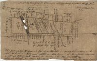
Copy of plan of a plantation on Stono Swamp commonly called Stono Plantation belonging to Thomas Ferguson. Contains 630 acres. Approximately 360 acres is swamp and approximately 270 acres is highland. Names associated with this plat are Thomas Ferguson, George Haig, Joseph Farr, Mary Williams, Smith and John McSweeney. Notable geographic locations include Stono Swamp, Stono Plantation and Charleston.
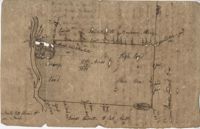
Plan of a tract of land on the NE side of Edisto River called Riverside Plantation and contains 1100 acres belonging to estate of Thomas Ferguson lately sold to Martin. Names associated with this plat included Benjamin Berry, Bull, Martin, John Eberley, Edward Perry, and Thomas Ferguson. Notable geographic locations include St. Paul's Parish, the Edisto River, Parkers Ferry, Public Road to Charleston, Riverside Plantation, and Charleston District.