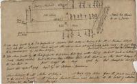
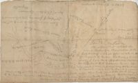
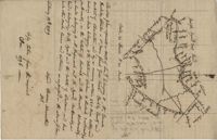
Copy of two adjoining plats of lands on Johns Island originally granted to Ambrose Hill now belonging to Miller St. John. Copied from the plats annexed to the original grants in 1795. Names associated with these plats are Ambrose Hill, Miller St. John, Richard Floyd, the Lords Proprietors, Job Howe, N. Johnson, Thomas Broughton and Lambert Lanee. Notable geographic locations include Johns Island, Ambrose Hill, Bohicket Creek, and Colleton County.
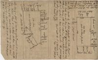
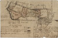
Plat of two tracts of land on Johns Island, both are 300 acres. Notes give a brief description of the properties, the drawings include very little detail. Names associated with this plat include John Prescot, Anthony Mathews, Graemede, the Lords Proprietors, Robert Cole, Robert Gibbs, Heufville, Arnold, Richard Floyd and Thomas Broughton. Notable geographic locations include Colleton County, Kywah [Kiawah] Creek, and Johns Island.
500 acre plat given to William Campbell in the Georgetown District on Kingston Lake Swamp, shows highlands, swamp, indigo area, and an area named food provision, shows details and surrounding property owners.
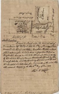
Plan of a parcel of land situated on Johns Island and containing 86 1/2 acres. Being part of a body of land belonging to Thomas Mathews. Bounded northwardly by a public road, eastwardly on James Legare's land, and southwardly on land belonging to Isaac Holmes and Thomas Legare. Intended to be conveyed to Isaac Holmes. Names associated with this plat are Thomas Mathews, Isaac Holmes, Thomas Legare, William Stanyarn, Matthews and James Legare.
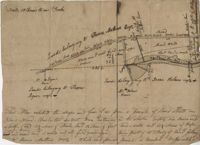
Plat of land which includes a marsh and creeks, very little other detail. Names associated with this plat are Purcell, Thomas Rose, John Blade, and E. Rivers. Notable geographic locations include Tiger Swamp.
Plat of 237 acres belonging to Rob Reeves Gibbes. Detailed marsh and high land along with the location and outline of a house. Names associated with this plat are Robert Reeve Gibbes, Nathaniel Heyward, John Gibbes, Thomas Gibbes, and Lewis Gibbes. Notable geographic locations include the Combahee River, Tupelo Swamp, and Charleston District.
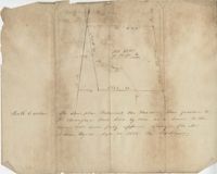
Sketch of the survey ad laying out of a small tract called Red Branch on the west side of the Cooper River containing 6 acres lately sold by Middleton to Leval part of 400 acres tract granted to Dr. Snow. Names associated with this plat are Peter Pamplat, Peter Gray, Snow, and Middleton.
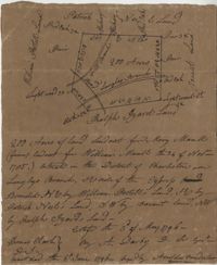
Plat includes Langley Branch Road going through plat as well as a road. Plat consists of 200 acres. Names associated with this plat are Mary Manlt, William Manlt, William Postell, Patrick Neel, Ralph Izard, Thomas Clark, A. Darby, Amoldus Vanderhorst, Margaret Manlt and W.S. Smith. Notable geographic locations include St. George’s Parish, Langley Branch, Cypress Road, Dorchester, Cypress Swamp, and Charleston District.
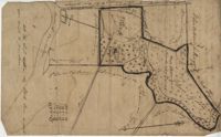
Plat contains 420 acres But is to the estate of Fulmer and Shubrick and to Shubreek and Hewart also bounding to Hapensack and Izard. Plat includes the location of the house and paths connecting the property to its neighbors. Names associated with this plat include William Conrade Heekeley, Shubrick, Fulmer, Hewart, Hapensack, Ralph Izard, and Thomas Abernethie. Notable geographic locations include St. James Parish, Goose Creek, Wolf Castell, Berkeley County, and Charleston District.
"A Plan of a Plantation or Tract of Land on Penny Creek a Branch of Ponpon or Edisto River late the property of Joseph Bee Esquire now belonging to John Champney Esquire." Plat contains 687 acres on the north side of Penny Creek the plat is divided by use of lands and the location of structures on the property. Names associated with this plat are John Champney, Dr. John Mitchell, Thomas Bee, Joseph Bee, and George Savage. Notable geographic locations include Penny Creek, Edisto River, Pon Pon River, Landing Road, and Bridge Road.