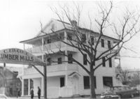
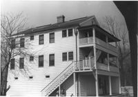
Cole Lumber Company, presumably main office building, on site affected by the construction of Interstate 26 (I-26). Sign arches over the entrance: C. Ed Cole Lumber Mills. Address from 1961 City Directory: 293 Huger Street. Address from 1951 Sanborn Map: 17 Huger Street. Surveyor notations on back of photo: "Dkt.: 10.517. Property owner: Charles E. Cole Lumber Co. Tract 1. Station: 5937+70 Lt. Date: February 21, 1963." [See collection description for explanation of surveyor notations.]
Cole Lumber Company, presumably main office building, on site affected by the construction of Interstate 26 (I-26). Address from 1961 City Directory: 293 Huger Street. Address from 1951 Sanborn Map: 17 Huger Street. Surveyor notations on back of photo: "Dkt.: 10.517. Property owner: Charles E. Cole Lumber Co. Tract 1. Station: 5937+70 Lt. Date: February 21, 1963." [See collection description for explanation of surveyor notations.]
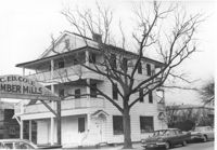
Cole Lumber Company, presumably main office building, on site affected by the construction of Interstate 26 (I-26). Address from 1961 City Directory: 293 Huger Street. Address from 1951 Sanborn Map: 17 Huger Street. Surveyor notations on back of photo: "Dkt.: 10.517. Property owner: Cole Lumber Co. Tract 1. Station: 5937+70 Lt. Date: March 5, 1963. In R/W - Bought." [See collection description for explanation of surveyor notations.]
Cole Lumber Company, presumably main office building, on site affected by the construction of Interstate 26 (I-26). Address from 1961 City Directory: 293 Huger Street. Address from 1951 Sanborn Map: 17 Huger Street. Surveyor notations on back of photo: "Dkt.: 10.517. Property owner: Cole Lumber Co. Tract 1. Station: 5937+70 Lt. Date: March 5, 1963. In R/W - Bought." [See collection description for explanation of surveyor notations.]
Cole Lumber Company, presumably main office building, on site affected by the construction of Interstate 26 (I-26). Address from 1961 City Directory: 293 Huger Street. Address from 1951 Sanborn Map: 17 Huger Street. Surveyor notations on back of photo: "Dkt.: 10.517. Property owner: Charles E. Cole Lumber Co. Tract 1. Station: 5937+70 Lt. Date: February 21, 1963." [See collection description for explanation of surveyor notations.]
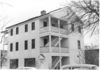
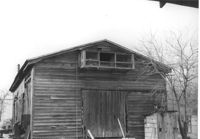
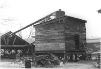
Cole Lumber Company structure, on site affected by the construction of Interstate 26 (I-26). Address from 1961 City Directory: 293 Huger Street. Address from 1951 Sanborn Map: 17 Huger Street. Surveyor notations on back of photo: "Dkt.: 10.517. Property owner: Charles E. Cole Lumber Co. Tract 1. Station: 5938+40 CL. Date: February 21, 1963." [See collection description for explanation of surveyor notations.]
Cole Lumber Company structure (rear view), on site affected by the construction of Interstate 26 (I-26). Address from 1961 City Directory: 293 Huger Street. Address from 1951 Sanborn Map: 17 Huger Street. Surveyor notations on back of photo: "Dkt.: 10.517. Property owner: Charles E. Cole Lumber Co. Tract 1. Station: 5938+40 CL. Date: February 21, 1963." [See collection description for explanation of surveyor notations.]
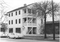
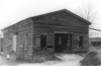
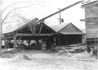
Cole Lumber Company structures, on site affected by the construction of Interstate 26 (I-26). Address from 1961 City Directory: 293 Huger Street. Address from 1951 Sanborn Map: 17 Huger Street. Surveyor notations on back of photo: "Dkt.: 10.517. Property owner: Cole Lumber Co. Tract 1. Station: 5938+80 Lt. Date: February 21, 1963." [See collection description for explanation of surveyor notations.]
Cole Lumber Company structures, on site affected by the construction of Interstate 26 (I-26). Address from 1961 City Directory: 293 Huger Street. Address from 1951 Sanborn Map: 17 Huger Street. Surveyor notations on back of photo: "Dkt.: 10.517. Property owner: Cole Lumber Co. Tract 1. Station: 5938+80 Lt. Date: February 21, 1963." [See collection description for explanation of surveyor notations.]
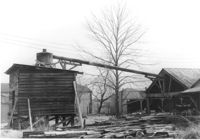
Cole Lumber Company structures, on site affected by the construction of Interstate 26 (I-26). Address from 1961 City Directory: 293 Huger Street. Address from 1951 Sanborn Map: 17 Huger Street. Surveyor notations on back of photo: "Dkt.: 10.517. Property owner: Cole Lumber Co. Tract 1. Station: 5939+50 CL. Date: February 21, 1963." [See collection description for explanation of surveyor notations.]
Right of way--South Carolina--Charleston County, Highway planning--South Carolina--Charleston County, Lost architecture--South Carolina--Charleston County, Lumber-yards--South Carolina--Charleston County✖[remove]13