Search
« Previous |
151 - 200 of 1,145
|
Next »
Search Results
Description:
List of city owned property in congested traffic areas compiled by the committee on "Inventory of City Owned Property in Congested Areas."
Date:
1945
Description:
Map of Area 1 bounded by George Street, St. Philip Street, Vanderhorst Street, Hutson Street, and Meeting Street assigned to Mrs. T W. Thornhill.
Date:
1945
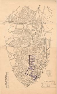
Description:
Map of Area 3 bounded by Beaufain Street, Hasell Street, Meeting Street, Broad Street, Legare Street, and Archdale Street assigned to Ferdinanda Waring.
Date:
1943
Description:
Letter to Frederick H. McDonald from J. S. Cator regarding an invitation to join the Community Development Council (Jan. 27, 1943).
Date:
1943
Description:
Letter to Frederick H. McDonald from E. P. Holcombe regarding an invitation to join the Community Development Council (Jan. 27, 1943).
Date:
1943
Description:
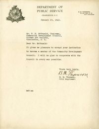
Letter to Frederick H. McDonald from B. M. Thomson regarding an invitation to join the Community Development Council (Jan. 29, 1943).
Date:
1942
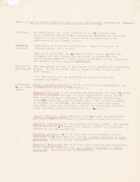
Description:
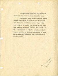
Document listing suggested immediate objectives of the Civic Services Committee
Date:
1942-11-17
Description:
Meeting report for the Charleston Regional Planning Committee that was held at the Gibbes Art Gallery (Nov. 17, 1942).
Date:
1941-12-01
Description:
Meeting report for the Charleston Regional Planning Committee that was held at the Gibbes Art Gallery (Dec. 1, 1941).
Description:
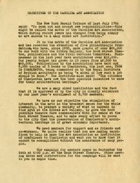
Report entitled "Objectives of the Carolina Art Association."
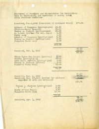
Description:
Statement of Receipts and expenditures for the "This is Charleston" Exhibition.
Date:
1945
Description:
Map of Area 2 bounded by George Street, Meeting Street, Philip Street, Beaufain Street, and Hasell Street assigned to Mrs. Thornhill and Mrs. Taft.
Date:
1945-03-18
Description:
Letter to Mr. [Henry P.] Staats from George W. Simons (Mar. 18, 1945) regarding income from parking meters in various cities..
Date:
1945
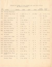
Description:
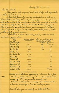
Parking survey of trucks, showing name on truck, name of store, time-in, time-out, and total time parked.
Date:
1945
Description:
Summary of length of time trucks and cars were parked in front of stores.
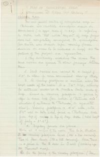
Description:
"General Plan" for "Map of Charleston Area" exhibit at the Gibbes Art Gallery.
Date:
1942-10-06
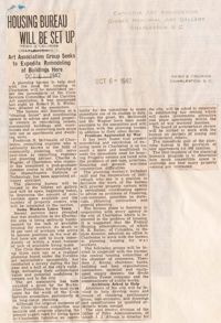
Description:
Article from the News and Courier entitled "Housing Bureau Will be Set Up" regarding a planning bureau to help with housing needs during the war (Oct. 6, 1942).
Date:
1942-10-05
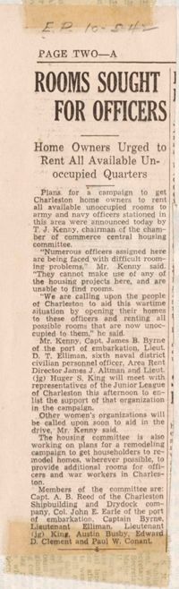
Description:
Article entitled "Rooms Sought for Officers" regarding room rentals for military officers (Oct. 5, 1942).
Date:
1943
Description:
Letter to Frederick H. McDonald from O. T. Wallace regarding members of the Community Development Council (Jan. 30, 1943).
Description:
Document regarding housing in Charleston for war workers.
Date:
1945-01-26
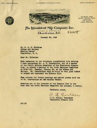
Description:
Letter from L. R. Culler (Woodstock Mfg. Company) to Robert N.S. Whitelaw regarding attendance at an upcoming CSC meeting (Jan. 26, 1945).
Date:
1943-08-06
Description:
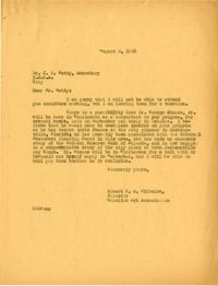
Letter to C. O. Getty from Robert N.S. Whitelaw regarding city planning (Aug. 6, 1943).
Date:
1942-10-20
Description:
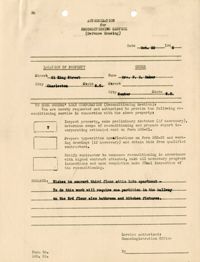
Authorization for Reconditioning Service. Applicant Mrs. F. R. Baker (Oct. 20, 1942).
Description:
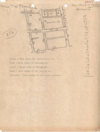
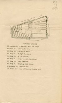
Map of area bounded by Archdale, Market, King and Beaufain Streets.
Description:
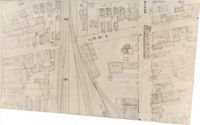
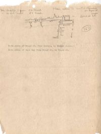
Map (not color-coded) of area around Reid Street and Meeting Street
Date:
1942-11-02, 1942-05-29, 1942-06-08, 1942-08-13
Description:
Series of News and Courier articles: "380 Demountable Homes Under Way" (May 29, 1942), "1,000 Families Need Homes Here" (June 8, 1942), "Housing Problem Greatest in S.C." (August 13, 1942), "Home Building Here Attains 3rd Best Level in 12 Years" (November 2, 1942).
Date:
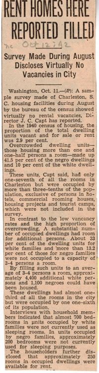
1942-10-20, 1942-10-12, 1942-10-27
Description:
Series of articles: "Rent Homes Here Reported Filled" (Oct. 12, 1942), "Henderson Rules Against Evictions" (Oct. 20, 1942), and "Government Rent to be Controlled" (Oct. 27, 1942).
Date:
1947-04-25
Description:
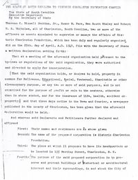
"The State of South Carolina to Historic Charleston Foundation Charter," dated April 25, 1947.
Date:
1941-07-30
Description:
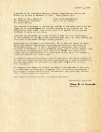
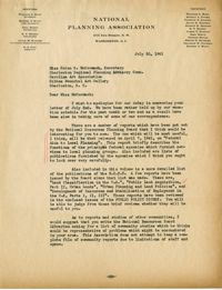
Letter to Helen Gardner McCormack from Virginia D. Parker (National Planning Association) (July 30, 1941) regarding publications by the National Resources Planning Board.
Date:
1939-12-20
Description:
Letter to John Mead Howells from Robert N.S. Whitelaw Dec. 20, 1939) about Howells's participation on the committee.
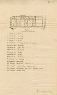
Description:
Map of area bounded by Jacob's Alley, Queen, King, and Archdale Street.
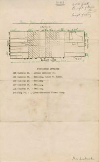
Description:
Map of area bounded by Burns Lane, Meeting, Calhoun, and King Street.
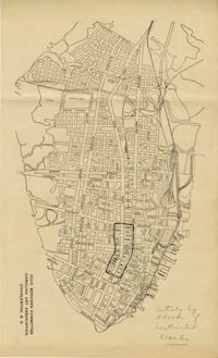
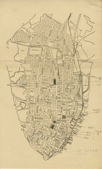
Description:
Map of peninsula.
Description:
Map of peninsula.
Date:
1941
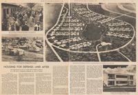
Description:
Clipping of New York Times magazine article "Housing for Defense--and After."
Description:
Notes on "How to Promote Community and Industrial Development" by Frederick H. McDonald.
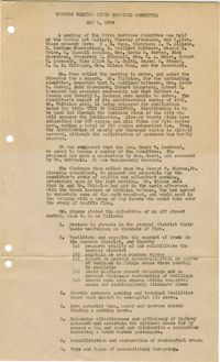
Date:
1944-05-09
Description:
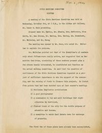
Meeting minutes of the Civic Services Committee (May 9, 1944).
Date:
1946-11-06
Description:
Meeting minutes of the Civic Services Committee (Nov. 6, 1946).
Date:
1947-03-07
Description:
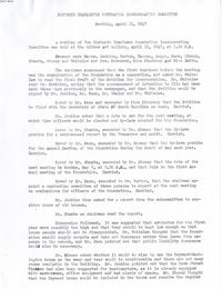
Minutes of the April 21, 1947, meeting of the Historic Charleston Foundation Incorporation Committee.
Date:
1945
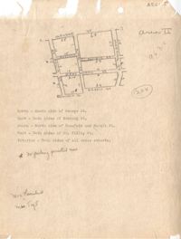
Description:
Map of Area 4 bounded by Broad Street, East Bay Street, and Tradd Street assigned to Mr. Martin Powers and Maier Triest.
Description:
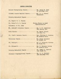
List of members of the Civic Services Committee Church Committee.
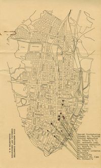
Description:
Map of the Charleston peninsula showing churches in congested areas.
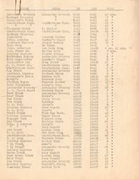
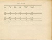
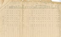
Description:
Table depicting the traffic violations from the year 1937-1942. The violations are broken down by race and gender.
Date:
1943-11-30
Description:
Letter to John S. Cator from Robert N.S. Whitelaw (Nov. 30, 1943) inviting him to attend upcoming meeting.
Date:
1951-02-05
Description:
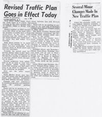
News and Courier article (Feb. 5, 1951), "Revised Traffic Plan Goes in Effect Today." Evening Post article (Feb. 6, 1951), "Several Minor Changes Made in New Traffic Plan."
Date:
1951-02-04
Description:
News and Courier article (Feb. 4, 1951), "Off Street Parking Advocated Five Years Ago Gradually Reaching Realization Here" and published statement by the Pastime Amusement Co. (Feb. 4, 1951), "We Welcome the Change."
Date:
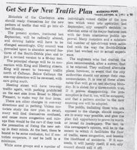
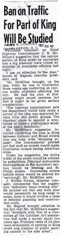
1947-10-28
Description:
News and Courier article (Oct. 28, 1947), "Ban on Traffic for Part of King Will be Studied."
Date:
1940
Description:
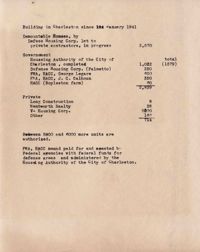
Document on census figures from 1940.
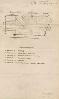
Description:
Map of area bounded by Wentworth, Meeting, and Hasell Street.
Date:
1940-05
Description:
Report cover.