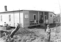
House (rear view) on site affected by the construction of Interstate 26 (I-26). Surveyor notations on back of photo: "Dkt.: 10.490. Property owner: Ruth V. Cooper. Tract: 26. Station: 5820+50 on CL. Date: March 22, 1962. In R/W - Bought." [See collection description for explanation of surveyor notations.]
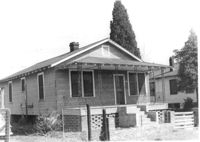
House on site affected by the construction of Interstate 26 (I-26). Building address number 2204. Surveyor notations on back of photo: "Dkt.: 10.490. Property owner: Joseph B. Cusack, Jr. Tract: 27. Station: 5820+50 Lt. Date: March 22, 1962. In R/W - Bought." [See collection description for explanation of surveyor notations.]
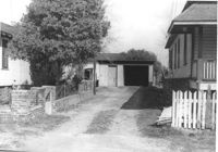
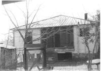
House, driveway, and shed/garage on site affected by the construction of Interstate 26 (I-26). Surveyor notations on back of photo: [Address number 2204.] "Dkt.: 10.490. Property owner: Joseph B. Cusack, Jr. Tract: 27. Station: 5820+50 Lt. Date: March 22, 1962. In R/W - Bought." [See collection description for explanation of surveyor notations.]
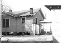
House (rear view) on site affected by the construction of Interstate 26 (I-26). [Building address number 2204.] Surveyor notations on back of photo: "Dkt.: 10.490. Property owner: Joseph B. Cusack, Jr. Tract: 27. Station: 5820+50 Lt. Date: March 22, 1962. In R/W - Bought." [See collection description for explanation of surveyor notations.]
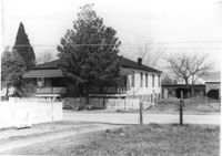
House on site affected by the construction of Interstate 26 (I-26). View from lot across the street. Surveyor notations on back of photo: "Dkt.: 10.490. Property owner: Mary F. Mitchum. Tract: 27-A. Station: 5820+50 Lt. Date: March 22, 1962. In R/W - Bought." [See collection description for explanation of surveyor notations.]
House (rear view) on site affected by the construction of Interstate 26 (I-26). Surveyor notations on back of photo: "Dkt.: 10.490. Property owner: Mary F. Mitchum. Tract: 27-A. Station: 5820+50 Lt. Date: March 22, 1962. In R/W - Bought." [See collection description for explanation of surveyor notations.]
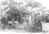
House in dilapidated condition, on site affected by the construction of Interstate 26 (I-26). Surveyor notations on back of photo: "Dkt.: 10.490. Property owner: Robert Ladson, et al. Tract: 29. Station: 5794+20 on CL Line A. Date: September 11, 1962. In R/W - Bought." [See collection description for explanation of surveyor notations.]
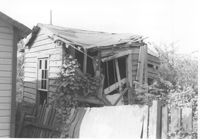
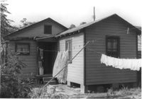
House in dilapidated condition (rear view), on site affected by the construction of Interstate 26 (I-26). Surveyor notations on back of photo: "Dkt.: 10.490. Property owner: Robert Ladson, et al. Tract: 29. Station: 5794+20 on CL Line A. Date: September 11, 1962. In R/W - Bought." [See collection description for explanation of surveyor notations.]
House (rear view) on site affected by the construction of Interstate 26 (I-26). Surveyor notations on back of photo: "Dkt.: 10.490. Property owner: Rev. Andrew Johnson, et al. Tract: 30. Station: 5794+45 on CL Line 'A'. Date: September 11, 1962. In R/W - Bought." [See collection description for explanation of surveyor notations.]
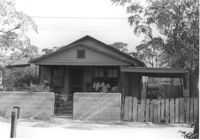
House on site affected by the construction of Interstate 26 (I-26). Surveyor notations on back of photo: "Dkt.: 10.490. Property owner: Rev. Andrew Johnson, et al. Tract: 30. Station: 5794+45 on CL Line 'A'. Date: September 11, 1962. In R/W - Bought." [See collection description for explanation of surveyor notations.]
Right of way--South Carolina--Charleston County, Highway planning--South Carolina--Charleston County, Vernacular architecture--South Carolina--Charleston County, Lost architecture--South Carolina--Charleston County, Dwellings--South Carolina--Charleston County✖[remove]348