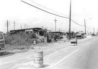
Lot on site affected by the construction of Interstate 26 (I-26). On Meeting Street/Meeting Street Road. View down street showing dilapidated structures on side of road, which is already a construction site. Surveyor notations on back of photo: "Dkt.: 10.510. Property owner: Geo. Fabian, Jr. Tract: 67. Station: 5801+60 - 5802+65 Lt. (Meeting Street). Date: Sept. 12, 1962. In R/W - Bought." [See collection description for explanation of surveyor notations.]
Small dilapidated building on site affected by the construction of Interstate 26 (I-26). Behind building in previous photograph (I-26 Photo 115). Surveyor notations on back of photo: "Dkt.: 10.471. Property owner: Willa W.S. Owens. Tract: 136. Station: 5477+80 Lt. Date: Aug. 23, 1960. In R/W - Bought." [See collection description for explanation of surveyor notations.]
Fenced-in lot between buildings with bricks and lumber strewn about, on site affected by the construction of Interstate 26 (I-26). Located south of 35 Poinsett Street. Surveyor notations on back of photo: "Dkt.: 10.503. Property owner: Carolina Dismantling Corp. Tract: 109-A. Station: 5928± to 5929± Lt. Date: Feb. 20, 1963." [See collection description for explanation of surveyor notations.]
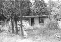
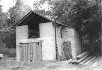
Cinder-block structure (shed?) on site affected by the construction of Interstate 26 (I-26). Surveyor notations on back of photo: "Dkt.: 10.480. Property owner: Crider O. Murray. Tract: 202. Station: 5689+80 Lt. Date: May 31, 1961. In R/W - Bought." [See collection description for explanation of surveyor notations.]
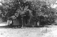
Cinderblock structure on site affected by the construction of Interstate 26 (I-26). Obscured by trees. Surveyor notations on back of photo: "Dkt.: 10.480. Property owner: Mrs. Margaret H. Patterson. Tract: 241. Station: 5702+60 Lt. Date: May 31, 1961. In R/W - Bought." [See collection description for explanation of surveyor notations.]
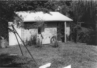
Cinderblock structure and doghouse, on site affected by the construction of Interstate 26 (I-26). Surveyor notations on back of photo: "Dkt.: 10.480. Property owner: D.T. Browning. Tract: 264. Station: 5714+60 Lt. Date: May 31, 1961. In R/W - Bought." [See collection description for explanation of surveyor notations.]
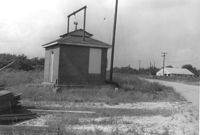
Small brick building, possibly a utility shed, on site affected by the construction of Interstate 26 (I-26). Coastal Motor Service (Photo 1307) in background, across the road. Surveyor notations on back of photo: "Dkt.: 10.490. Property owner: St. Phillips and St. Michael Pub. Service [St. Phillips and St. Michael Public Service]. Tract: 145. Station: 5877+67 Rt. 83' CL. Date: September 11, 1962. Moving item." [See collection description for explanation of surveyor notations.]
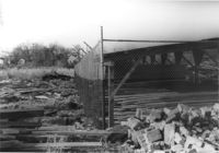
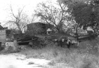
Lot with collapsed building, on site affected by the construction of the Crosstown. Address: 3 Rosemont Street. Surveyor notations on back of photo: "Dkt.: 10.524. Property owner: Christopher Ward. Tract: 54. Station: 71+70 Rt. Date: Oct. 14, 1964." [See collection description for explanation of surveyor notations.]
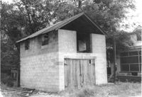
Cinder block structure (garage?) on site affected by the construction of the Crosstown. Address: 110 Bogard Street. Surveyor notations on back of photo: "Dkt.: 10.524. Property owner: Thomassina Elizabeth McCray. Tract: 72. Station: 76+60 Rt. Date: Oct. 14, 1964. In R/W - Bought." [See collection description for explanation of surveyor notations.]
Cinder block structure (garage?) on site affected by the construction of the Crosstown. Address: 110 Bogard Street. Surveyor notations on back of photo: "Dkt.: 10.524. Property owner: Thomassina Elizabeth McCray. Tract: 72. Station: 76+60 Rt. Date: Oct. 14, 1964. In R/W - Bought." [See collection description for explanation of surveyor notations.]
Right of way--South Carolina--Charleston County, Highway planning--South Carolina--Charleston County, Lost architecture--South Carolina--Charleston County✖[remove]11
Charleston County (S.C.)--Buildings, structures, etc.✖[remove]11