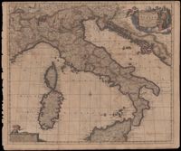
Map of the Italian piedmont by Thomas Blaeu (1596-1673). Similar to Tabula Generalis Sabaudiae by Blaeu and slightly overlapping in coverage. First published by Blaeu's heirs after his death in his town book of Savoy and Piedmont. Map was designed by Giovanni Tommaso Borgonio (1620-1683) and engraved by Johannes de Broen (1649-1730). Amsterdam. 52 x 62cm.
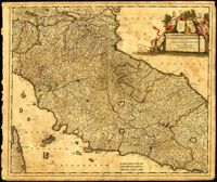
Map of central Italy by Frederick de Wit (1630-1706) showing the grand duchy of Tuscany and the papal states. Title cartouche is decorated with the ball-motif shield of the Medici family; the papal states are represented by the Keys of St. Peter on a shield. Detail on the map includes a road that extends from Rimina on the Gulf of Venetia to Piacenza in the northeast. Amsterdam. 52 x 62cm.
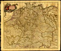
Map of central Europe by Justus Danckerts (1635-1701). Map extends from France in the west to Poland in the east and from Croatia and Italy in the south to the Netherlands in the north. The Hapsburg eagle holds the title banner in the upper left cartouche. Amsterdam. 52 x 62cm.
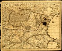
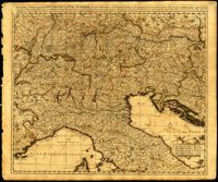
One of three maps by Nicolaes Visscher (1649-1702) collectively showing the entire length of the Danube. This map depicts the upper Danube from its start in Germany to Bratislava (Presburg on map). Amsterdam. 52 x 62cm.
Black-and-white engraving depicting Moses and the Ten Commandments. Engraving by Peter van Lisebetten after a painting by Valentin de Boulogne. From Davidis Teniers Antverpiensis, pictoris, et a cubiculis by David Teniers.
One of three maps by Nicolaes Visscher (1649-1702) collectively showing the entire length of the Danube. This map covers the middle part of the river from Linz through Vienna, Bratislava and Budapest, to just east of Belgrade. Amsterdam. 52 x 62cm.
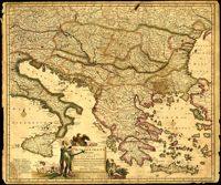
One of three maps by Nicolaes Visscher (1649-1702) collectively showing the entire length of the Danube. This map depicts the lower Danube from Belgrade to its mouth in the Black Sea. Amsterdam. 52 x 62cm.
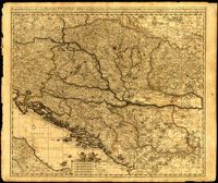
Map by Justus Danckerts (1635-1701) covers the Danube River from Germany to the Black Sea. Depicts all of the Balkans, Hungary, Romania and parts of Austria, Italy and Germany. The map was apparently printed at the height of the Ottoman wars against the European powers in the late seventeenth century. A table in the lower left depicts the names of cities in the Hungarian kingdom that were lost to the Ottomans and when they were recovered to date. The latest date on the table is 1687. However, according to the table, the recapture of Buda (Budapest) took place in 1686 but an examination of Buda on the map reveals a date of 1688. Other known examples of this map include the recovery of Belgrade (Belgrado) in 1688 in the table although this version of the map does not. It is possible this map was printed immediately before the Siege of Belgrade in 1688 or after 1690 when the city was reclaimed by the Turks (and the subsequent reference to Belgrado in the table may have been expunged). Title cartouche depicts a Christian saint and the Hapsburg eagle. Amsterdam. 52 x 62cm.
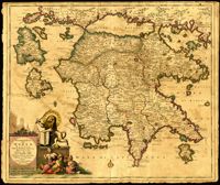
Map of the Peloponnese in southern Greece by Justus Danckerts (1635-1701). Written next to many cities on the map (Athens, Corinth) are the dates they were recovered by the Venetians from Ottoman control. Latest date found on map is 1687. Title cartouche depicts the Venetian lion towering over Turkish soldiers. Amsterdam. 52 x 62cm.

![[Plate 240]](https://iiif.library.cofc.edu/iiif/2/40188/full/200,/0/default.jpg)