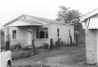
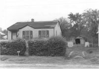
House on site affected by the construction of Interstate 26 (I-26). Surveyor notations on back of photo: "Dkt.: 10.480. Property owner: Andrew Smalls, Est. Tract: 42-A. Station: 5511+00 Lt. Date: May 1, 1961. In R/W - Bought." [See collection description for explanation of surveyor notations.]
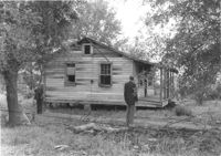
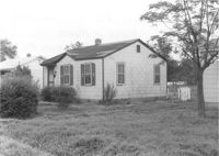
House on site affected by the construction of Interstate 26 (I-26). Surveyor notations on back of photo: "Dkt.: 10.480. Property owner: Simon Simmons. Tract: 49. Station: 5514+80 Lt. Date: May 1, 1961. In R/W - Bought." [See collection description for explanation of surveyor notations.]
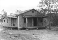
Dwelling on site affected by the construction of Interstate 26 (I-26). Surveyor notations on back of photo: "Dkt.: 10.480. Property owner: Simon Simmons. Tract: 49. Station: 5513+80 Lt. Date: May 1, 1961. In R/W - Bought." [See collection description for explanation of surveyor notations.]
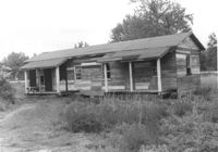
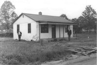
House on site affected by the construction of Interstate 26 (I-26). Neighboring (rear) houses and structures in background. Surveyor notations on back of photo: "Dkt.: 10.480. Property owner: Rochell Dinkins, et al. Tract: 59. Station: 5516+80 Lt. Date: May 1, 1961. In R/W - Bought." [See collection description for explanation of surveyor notations.]
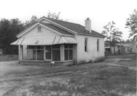
House on site affected by the construction of Interstate 26 (I-26). Surveyor notations on back of photo: "Dkt.: 10.480. Property owner: Charles Small, et al. Tract 70. Station: 5517+80 Rt. Date: May 1, 1961. In R/W - Bought." [See collection description for explanation of surveyor notations.]
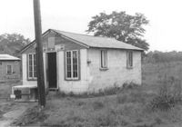
Small cinder block building, presumably formerly a market (Pepsi signage over door), on site affected by the construction of Interstate 26 (I-26). Surveyor notations on back of photo: "Dkt.: 10.480. Property owner: J.C. Griffin, et al. Tract: 76. Station: 5520+30 Lt. Date: May 1, 1961. In R/W - Bought." [See collection description for explanation of surveyor notations.]
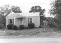
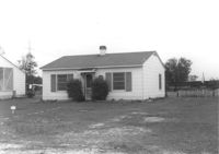
House on site affected by the construction of Interstate 26 (I-26). Surveyor notations on back of photo: "Dkt.: 10.480. Property owner: Mary Broomfield. Tract: 95. Station: 5522+70 Rt. Date: May 1, 1961. In R/W - Bought." [See collection description for explanation of surveyor notations.]
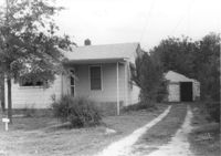
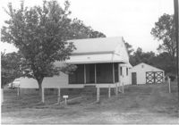
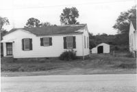
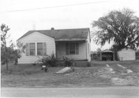
House on site affected by the construction of Interstate 26 (I-26). Driveway leads to garage/shed. Surveyor notations on back of photo: "Dkt.: 10.480. Property owner: James W. Sadler. Tract: 123. Station: 5647+60 Lt. Date: May 1, 1961. In R/W - Bought." [See collection description for explanation of surveyor notations.]
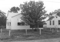
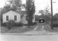
House on site affected by the construction of Interstate 26 (I-26). Driveway leads to garage/shed. Surveyor notations on back of photo: "Dkt.: 10.480. Property owner: Marie J. Pounds. Tract: 124. Station: 5648+00 Rt. Date: May 1, 1961. In R/W - Bought." [See collection description for explanation of surveyor notations.]
House (corner view) on site affected by the construction of Interstate 26 (I-26). Surveyor notations on back of photo: "Dkt.: 10.480. Property owner: Marie J. Pounds. Tract: 124. Station: 5648+00 Rt. Date: May 1, 1961. In R/W - Bought." [See collection description for explanation of surveyor notations.]
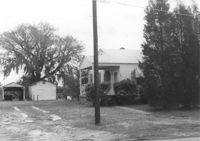
House on site affected by the construction of Interstate 26 (I-26). Driveway leads to garage/shed. Surveyor notations on back of photo: "Dkt.: 10.480. Property owner: O.C. House, et al. Tract: 129. Station: 5651+25 Rt. Date: May 1, 1961. In R/W - Bought." [See collection description for explanation of surveyor notations.]
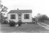
House on site affected by the construction of Interstate 26 (I-26). Surveyor notations on back of photo: "Dkt.: 10.480. Property owner: O.C. House, et al. Tract: 129. Station: 5651+25 Rt. Date: May 1, 1961. In R/W - Bought." [See collection description for explanation of surveyor notations.]
House on site affected by the construction of Interstate 26 (I-26). Driveway leads to garage/shed. Surveyor notations on back of photo: "Dkt.: 10.480. Property owner: Evan L. Stigall. Tract: 130. Station: 5651+50 Rt. Date: May 1, 1961. In R/W - Bought." [See collection description for explanation of surveyor notations.]
House on site affected by the construction of Interstate 26 (I-26). Building address number 191. Driveway leads to garage/shed. Surveyor notations on back of photo: "Dkt.: 10.480. Property owner: John S. Singleton. Tract: 132. Station: 5652+80 Rt. Date: May 1, 1961. In R/W - Bought." [See collection description for explanation of surveyor notations.]
House on site affected by the construction of Interstate 26 (I-26). Driveway leads to garage/shed. Surveyor notations on back of photo: "Dkt.: 10.480. Property owner: L.K. Goodale. Tract: 133. Station: 5653+50 Rt. Date: May 1, 1961. In R/W - Bought." [See collection description for explanation of surveyor notations.]
House on site affected by the construction of Interstate 26 (I-26). Driveway leads to garage/shed. Surveyor notations on back of photo: "Dkt.: 10.480. Property owner: Shade R. Rogers. Tract: 138. Station: 5656+40 Rt. Date: May 1, 1961. In R/W - Bought." [See collection description for explanation of surveyor notations.]
House on site affected by the construction of Interstate 26 (I-26). Driveway leads to shed. Surveyor notations on back of photo: "Dkt.: 10.480. Property owner: V.J. Bouranick. Tract: 139. Station: 5657+00 Rt. Date: May 1, 1961. In R/W - Bought." [See collection description for explanation of surveyor notations.]
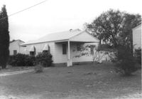
House and outbuilding on site affected by the construction of Interstate 26 (I-26). Surveyor notations on back of photo: "Dkt.: 10.480. Property owner: G.B. Lewis. Tract: 140. Station: 5657+60 Rt. Date: May 1, 1961. In R/W - Bought." [See collection description for explanation of surveyor notations.]
House on site affected by the construction of Interstate 26 (I-26). Surveyor notations on back of photo: "Dkt.: 10.480. Property owner: G.B. Lewis. Tract: 140. Station: 5657+60 Rt. Date: May 1, 1961. In R/W - Bought." [See collection description for explanation of surveyor notations.]
House on site affected by the construction of Interstate 26 (I-26). Surveyor notations on back of photo: "Dkt.: 10.480. Property owner: S.G. Carroll, Sr. Tract: 142. Station: 5658+80 Rt. Date: May 1, 1961. In R/W - Bought." [See collection description for explanation of surveyor notations.]