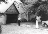
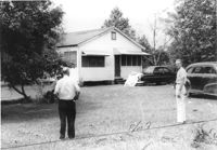
House and garage on site affected by the construction of Interstate 26 (I-26). Surveyor notations on back of photo: "Dkt.: 10.471. Property owner: Otis H. Schofill. Tract: 35. Station: 5321+90 Rt. Date: Aug. 23, 1960. In R/W - Bought." [See collection description for explanation of surveyor notations.]
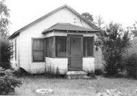
House on site affected by the construction of Interstate 26 (I-26). Surveyor notations on back of photo: "Dkt.: 10.471. Property owner: May Belle Locklair. Tract: 36. Station: 5323+50 Lt. Date: Aug. 23, 1960. In R/W - Bought." [See collection description for explanation of surveyor notations.]
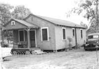
House on site affected by the construction of Interstate 26 (I-26). Surveyor notations on back of photo: "Dkt.: 10.471. Property owner: Katie S. Smith. Tract: 37. Station: 5323+80 Lt. Date: Aug. 23, 1960. In R/W - Bought." [See collection description for explanation of surveyor notations.]
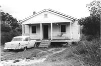
House on site affected by the construction of Interstate 26 (I-26). Surveyor notations on back of photo: "Dkt.: 10.471. Property owner: W.L. McDonald, et al. Tract: 38. Station: 5326+00 Rt. Date: Aug. 23, 1960. In R/W - Bought." [See collection description for explanation of surveyor notations.]
House on site affected by the construction of Interstate 26 (I-26). Surveyor notations on back of photo: "Dkt.: 10.471. Property owner: E.T. Walling. Tract: 39. Station: 5324+30 Lt. Date: Aug. 23, 1960. In R/W - Bought." [See collection description for explanation of surveyor notations.]
House on site affected by the construction of Interstate 26 (I-26). Surveyor notations on back of photo: "Dkt.: 10.471. Property owner: Ruth H. Snipes. Tract: 40. Station: 5323+50 Rt. Date: Aug. 23, 1960. Proximity." [See collection description for explanation of surveyor notations.]
House on site affected by the construction of Interstate 26 (I-26). Surveyor notations on back of photo: "Dkt.: 10.471. Property owner: J.E. Walling. Tract: 41. Station: 5325+15 Rt. Date: Aug. 23, 1960. In R/W - Bought." [See collection description for explanation of surveyor notations.]
House on site affected by the construction of Interstate 26 (I-26). Surveyor notations on back of photo: "Dkt.: 10.471. Property owner: M.L. Shipman, et al. Tract: 42. Station: 5326+75 Rt. Date: Aug. 23, 1960. Proximity." [See collection description for explanation of surveyor notations.]
House on site affected by the construction of Interstate 26 (I-26). Surveyor notations on back of photo: "Dkt.: 10.471. Property owner: W.W. Gregory. Tract: 46. Station: 5329+60 Rt. Date: Aug. 23, 1960. Proximity." [See collection description for explanation of surveyor notations.]
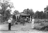
House (rear view) and outbuildings on site affected by the construction of Interstate 26 (I-26). Surveyor notations on back of photo: "Dkt.: 10.471. Property owner: Susie O. Morris. Tract: 76. Station: 5358+50 Rt. Date: Aug. 23, 1960. Proximity." [See collection description for explanation of surveyor notations.]
Right of way--South Carolina--Charleston County, Highway planning--South Carolina--Charleston County, Vernacular architecture--South Carolina--Charleston County, Lost architecture--South Carolina--Charleston County, Dwellings--South Carolina--Charleston County✖[remove]61