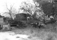
Lot with collapsed building, on site affected by the construction of the Crosstown. Address: 3 Rosemont Street. Surveyor notations on back of photo: "Dkt.: 10.524. Property owner: Christopher Ward. Tract: 54. Station: 71+70 Rt. Date: Oct. 14, 1964." [See collection description for explanation of surveyor notations.]
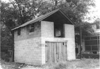
Cinder block structure (garage?) on site affected by the construction of the Crosstown. Address: 110 Bogard Street. Surveyor notations on back of photo: "Dkt.: 10.524. Property owner: Thomassina Elizabeth McCray. Tract: 72. Station: 76+60 Rt. Date: Oct. 14, 1964. In R/W - Bought." [See collection description for explanation of surveyor notations.]
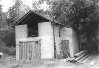
Cinder block structure (garage?) on site affected by the construction of the Crosstown. Address: 110 Bogard Street. Surveyor notations on back of photo: "Dkt.: 10.524. Property owner: Thomassina Elizabeth McCray. Tract: 72. Station: 76+60 Rt. Date: Oct. 14, 1964. In R/W - Bought." [See collection description for explanation of surveyor notations.]
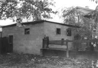
Cinder block structure on site affected by the construction of the Crosstown. Address: 15 Kennedy Street. Surveyor notations on back of photo: "Dkt.: 10.524. Property owner: J. Arthur Brown. Tract: 84. Station: 78+35 Lt. Date: Oct. 14, 1964. In R/W - Bought." [See collection description for explanation of surveyor notations.]
Limit your search
SCDOT Photographs: Properties in the Right-of-Way✖[remove]4
Right of way--South Carolina--Charleston County, Highway planning--South Carolina--Charleston County, Lost architecture--South Carolina--Charleston County✖[remove]4