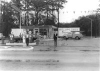
Spar gas station, on site affected by the widening of Route 171 (Folly Road). Surveyor notations on back of photo: "Dkt.: 10.494. Property owner: Palm Oil Co. Tract: 45. Station: 176+80 Lt. Date: Mar. 21, 1962. Owner to move pumps. [See collection description for explanation of surveyor notations.]
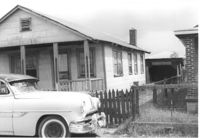
House on site affected by the construction of Interstate 26 (I-26). Surveyor notations on back of photo: "Dkt.: 10.490. Property owner: Louis Green. Tract: 138-B. Station: 5858+70 Lt. Date: August 29, 1962. In R/W - Bought." [See collection description for explanation of surveyor notations.]
House (rear view) on site affected by the construction of Interstate 26 (I-26). Surveyor notations on back of photo: "Dkt.: 10.490. Property owner: Louis Green. Tract: 138-B. Station: 5858+70 Lt. Date: August 29, 1962. In R/W - Bought." [See collection description for explanation of surveyor notations.]
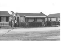
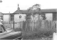
House on site affected by the construction of Interstate 26 (I-26). Surveyor notations on back of photo: "Dkt.: 10.490. Property owner: Henry Ford, et al. Tract: 138-C. Station: 5858+40 Lt. Date: August 29, 1962. In R/W - Bought." [See collection description for explanation of surveyor notations.]
House (rear view) on site affected by the construction of Interstate 26 (I-26). Surveyor notations on back of photo: "Dkt.: 10.490. Property owner: Henry Ford, et al. Tract: 138-C. Station: 5858+40 Lt. Date: August 29, 1962. In R/W - Bought." [See collection description for explanation of surveyor notations.]
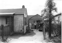
House (partial view) and structure at end of driveway, on site affected by the construction of Interstate 26 (I-26). Surveyor notations on back of photo: "Dkt.: 10.490. Property owner: Sadie Gilliard, et al. Tract: 138-D. Station: 5858+80 Lt. Date: May 15, 1962. Proximity." [See collection description for explanation of surveyor notations.]
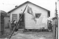
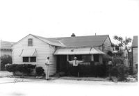
House on site affected by the construction of Interstate 26 (I-26). Building address number 2135. Surveyor notations on back of photo: "Dkt.: 10.490. Property owner: Sheppard Siders. Tract: 138-E. Station: 5858+00 Lt. Date: May 15, 1962. Owner to cut porch to clear R/W." [See collection description for explanation of surveyor notations.]
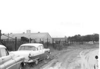
Dirt road and Charleston Oil Co. structures, on site affected by the construction of Interstate 26 (I-26). Surveyor notations on back of photo: "Dkt.: 10.490. Property owner: Charleston Oil Co. Tract: 140 and 140-A. Station: 5861+51 Rt. and Lt. (crosses CL). Date: August 29, 1962. In R/W - Bought." [See collection description for explanation of surveyor notations.]
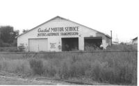
Coastal Motor Service, on site affected by the construction of Interstate 26 (I-26). Surveyor notations on back of photo: "Dkt.: 10.490. Property owner: Ashley River Realty Co. Tract: 141. Station: 5872+00 Lt. Date: August 29, 1962. Proximity." [See collection description for explanation of surveyor notations.]
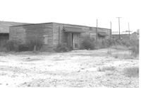
Structure on site affected by the construction of Interstate 26 (I-26). Surveyor notations on back of photo: "Dkt.: 10.490. Property owner: Ashley River Realty Co. Tract: 142. Station: 5876+60 Lt. Date: August 29, 1962. In R/W - Bought." [See collection description for explanation of surveyor notations.]