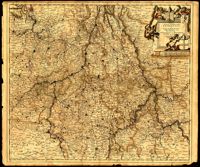
This map by Theodore Danckerts (1663-1727) details the bishoprics of Liege, Cologne and Trier and the duchies of Berg and Julich. Map covers the area surrounding the Meuse, Rhine and Moselle rivers and includes parts of modern day Belgium, the Netherlands, Germany, Luxembourg and France. Decorative title cartouche with putti holding the shields of the regions. Amsterdam. 52 x 62cm.
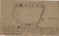
200 acres laid out to Joan Gryce, on the northwest side of Keywaw [Kiawah] Creek in Colleton County, on the left side it is bordered by the Marshes of Bohicket Creek. Names associated with this plat are Joan Gryce and James Witter. Notable geographic locations include Johns Island, Keywaw [Kiawah] Creek, and Bohicket Creek.