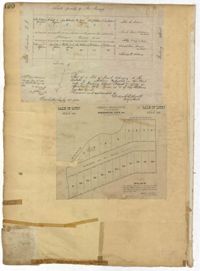
Page 170 of the City Engineer's Plat Book with four plats. Plat 1 shows lots located between King Street and Meeting Street, and between Romney Street and Grove Street. Plat 2 shows lots located between King Street and Meeting Street, and between Brigade Street and Mount Pleasant Street. Plat 4 shows lots located on Butler Street, near its intersection with Russell Street. Plat 5 features a lot labelled "Reservoir," located between Hanover Street and America Street.
Page 190 of the City Engineer's Plat Book with two plats. Plat 1 shows lots located along Addison's Court, between Meeting Street and a lot owned by the South Carolina Rail Road. Plat 2 shows lots along Kennedy Street, near Line Street and a stretch of Marsh.
A report from the mayor, city council and various governmental departments of Charleston, South Carolina, for the year 1890. The Year Book opens with an address from Mayor Bryan followed by reports from various departments.
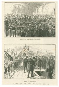
Black-and-white offset print reproduction depicting the funeral of Rabbi Nathan Marcus Adler at the Willesden United Synagogue Cemetery. Published in the February 1, 1890, edition of The Illustrated London News.
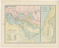
Color lithographic maps showing the dispersal of the descendants of Noah after the flood, and the twelve tribes of Israel, with additional biblical maps. From Cram's universal atlas : geographical, astronomical and historical by George F. Cram, published Chicago: George F. Cram.