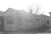
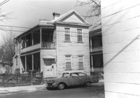
House on site affected by the construction of Interstate 26 (I-26). Address: 6 Maple Street. Surveyor notations on back of photo: "Dkt.: 10.503. Property owner: Atlantic Coast Life Ins. Co., et al. Tract: 49. Station: 5906+25 Lt. on CL. Date: Feb. 19, 1963. In R/W - Bought." [See collection description for explanation of surveyor notations.]
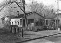
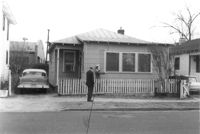
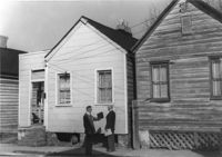
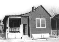
House on site affected by the construction of the Crosstown. Address: 96 Sheppard Street. Surveyor notations on back of photo: "Dkt.: 10.518. Property owner: Celia McFadden. Tract: 18. Station: 30+10 Lt. Sheppard Street. Date: Mar. 6, 1963. In R/W - Bought. [See collection description for explanation of surveyor notations.]
Portion of house (rear view) on site affected by the construction of Interstate 26 (I-26). Address: 6 Maple Street. Surveyor notations on back of photo: "Dkt.: 10.503. Property owner: Atlantic Coast Life Ins. Co., et al. Tract: 49. Station: 5906+25 Lt. on CL. Date: Feb. 19, 1963. In R/W - Bought." [See collection description for explanation of surveyor notations.]
House (rear view) on site affected by the construction of Interstate 26 (I-26). Address: 8 Maple Street. Surveyor notations on back of photo: "Dkt.: 10.503. Property owner: Atlantic Coast Life Ins. Co., et al. Tract: 50. Station: 5906+30 Rt. Date: Feb. 19, 1963. In R/W - Bought." [See collection description for explanation of surveyor notations.]
House on site affected by the construction of Interstate 26 (I-26).Address: 8 Maple Street. Surveyor notations on back of photo: "Dkt.: 10.503. Property owner: Atlantic Coast Life Ins. Co., et al. Tract: 50. Station: 5906+30 Rt. Date: Feb. 19, 1963. In R/W - Bought." [See collection description for explanation of surveyor notations.]
House on site affected by the construction of Interstate 26 (I-26). Address: 10 Maple Street. Surveyor notations on back of photo: "Dkt.: 10.503. Property owner: Gertrude C. Tindall, Est. Tract: 51. Station: 5906+40 Rt. Date: Feb. 19, 1963. In R/W - Bought." [See collection description for explanation of surveyor notations.]
House (rear view) on site affected by the construction of Interstate 26 (I-26). Address: 10 Maple Street. Surveyor notations on back of photo: "Dkt.: 10.503. Property owner: Gertrude C. Tindall, Est. Tract: 51. Station: 5906+40 Rt. Date: Feb. 19, 1963. In R/W - Bought." [See collection description for explanation of surveyor notations.]
House (rear view) on site affected by the construction of Interstate 26 (I-26). Address: 12 Maple Street. Surveyor notations on back of photo: "Dkt.: 10.503. Property owner: Atlantic Coast Life Ins. Co., et al. Tract: 52. Station: 5906+45 Rt. Date: Feb. 19, 1963. In R/W - Bought." [See collection description for explanation of surveyor notations.]
House on site affected by the construction of Interstate 26 (I-26). Address: 12 Maple Street. Surveyor notations on back of photo: "Dkt.: 10.503. Property owner: Atlantic Coast Life Ins. Co., et al. Tract: 52. Station: 5906+45 Rt. Date: Feb. 19, 1963. In R/W - Bought." [See collection description for explanation of surveyor notations.]
House on site affected by the construction of Interstate 26 (I-26). Address: 13 Maple Street. Surveyor notations on back of photo: "Dkt.: 10.503. Property owner: Aliene Cox Tindall. Tract: 53. Station: 5907+65 Rt. Date: Feb. 19, 1963. In R/W - Bought." [See collection description for explanation of surveyor notations.]
House (rear view) on site affected by the construction of Interstate 26 (I-26). Address: 13 Maple Street. Surveyor notations on back of photo: "Dkt.: 10.503. Property owner: Aliene Cox Tindall. Tract: 53. Station: 5907+65 Rt. Date: Feb. 19, 1963. In R/W - Bought." [See collection description for explanation of surveyor notations.]
House on site affected by the construction of Interstate 26 (I-26). Address: 11 Maple Street. Surveyor notations on back of photo: "Dkt.: 10.503. Property owner: James L. Tyler. Tract: 54. Station: 5907+50 Rt. Date: Feb. 19, 1963. In R/W - Bought." [See collection description for explanation of surveyor notations.]
House on site affected by the construction of the Crosstown. Address: 96 Sheppard Street. Surveyor notations on back of photo: "Dkt.: 10.518. Property owner: Celia McFadden. Tract: 18. Station: 30+10 Lt. Sheppard Street. Date: Mar. 6, 1963. In R/W - Bought. [See collection description for explanation of surveyor notations.]
House (rear view) on site affected by the construction of Interstate 26 (I-26). Address: 11 Maple Street. Surveyor notations on back of photo: "Dkt.: 10.503. Property owner: James L. Tyler. Tract: 54. Station: 5907+50 Rt. Date: Feb. 19, 1963. In R/W - Bought." [See collection description for explanation of surveyor notations.]
House (rear view) on site affected by the construction of Interstate 26 (I-26). Address: 9 Maple Street. Surveyor notations on back of photo: "Dkt.: 10.503. Property owner: Kiki Zicoupolis, et al. Tract: 55. Station: 5907+45 CL. Date: Feb. 19, 1963. In R/W - Bought." [See collection description for explanation of surveyor notations.]
House on site affected by the construction of Interstate 26 (I-26). Address: 9 Maple Street. Surveyor notations on back of photo: "Dkt.: 10.503. Property owner: Kiki Zicoupolis, et al. Tract: 55. Station: 5907+45 CL. Date: Feb. 19, 1963. In R/W - Bought." [See collection description for explanation of surveyor notations.]
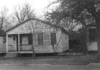
House on site affected by the construction of Interstate 26 (I-26). Address: 7 Maple Street. Surveyor notations on back of photo: "Dkt.: 10.503. Property owner: James M. Knox. Tract: 56. Station: 5907+45 Lt. Date: Feb. 19, 1963. In R/W - Bought." [See collection description for explanation of surveyor notations.]
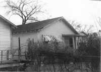
House (side view, rear) on site affected by the construction of Interstate 26 (I-26). Address: 7 Maple Street. Surveyor notations on back of photo: "Dkt.: 10.503. Property owner: James M. Knox. Tract: 56. Station: 5907+45 Lt. Date: Feb. 19, 1963. In R/W - Bought." [See collection description for explanation of surveyor notations.]
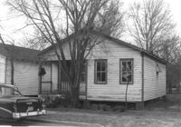
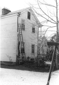
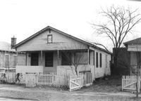
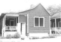
House on site affected by the construction of Interstate 26 (I-26).Address: 5 Maple Street. Surveyor notations on back of photo: "Dkt.: 10.503. Property owner: Harry B. Chassereau. Tract: 57. Station: 5907+35 Lt. Date: Feb. 19, 1963." [See collection description for explanation of surveyor notations.]
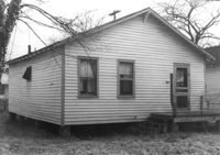
House (rear view) on site affected by the construction of Interstate 26 (I-26). Address: 5 Maple Street. Surveyor notations on back of photo: "Dkt.: 10.503. Property owner: Harry B. Chassereau. Tract: 57. Station: 5907+35 Lt. Date: Feb. 19, 1963." [See collection description for explanation of surveyor notations.]
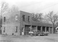
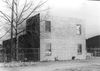
Commercial building with 6 bays (garage?) on site affected by the construction of Interstate 26 (I-26). Address: 739 Meeting Street. Surveyor notations on back of photo: "Dkt.: 10.503. Property owner: Alton M. Silver. Tract: 58. Station: 5908+15 Lt. Date: Feb. 20, 1963. In R/W - Bought." [See collection description for explanation of surveyor notations.]
Side view of commercial building with 6 bays (garage?) on site affected by the construction of Interstate 26 (I-26). Address: 739 Meeting Street. Surveyor notations on back of photo: "Dkt.: 10.503. Property owner: Alton M. Silver. Tract: 58. Station: 5908+15 Lt. Date: Feb. 20, 1963. In R/W - Bought." [See collection description for explanation of surveyor notations.]
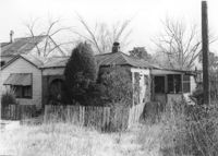
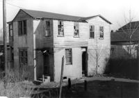
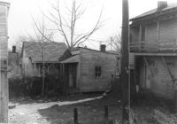
House-like structure on site affected by the construction of Interstate 26 (I-26). Address: 739 Meeting Street. Surveyor notations on back of photo: "Dkt.: 10.503. Property owner: George E. Williams. Tract: 60. Station: 5909+30 Rt. Date: Feb. 20, 1963. In R/W - Bought." [See collection description for explanation of surveyor notations.]
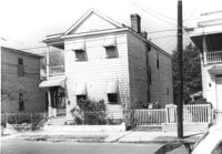
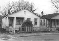
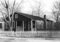
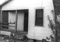
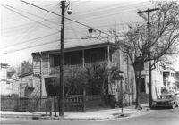
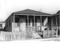
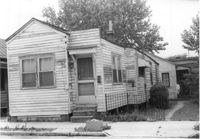
Street corner and houses on site affected by the construction of the Crosstown. Address: 100 Sheppard Street. Surveyor notations on back of photo: "Dkt.: 10.518. Property owner: M.J. Christine Butt, Est. Tract: 19. Station: 29+40 Lt. Sheppard Street. Date: Mar. 6, 1963. In R/W - Bought. [See collection description for explanation of surveyor notations.]
House-like structure (rear view) and neighboring structures on site affected by the construction of Interstate 26 (I-26). Address: 739 Meeting Street. Surveyor notations on back of photo: "Dkt.: 10.503. Property owner: George E. Williams. Tract: 60. Station: 5909+30 Rt. Date: Feb. 20, 1963. In R/W - Bought." [See collection description for explanation of surveyor notations.]
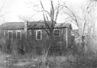
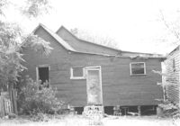
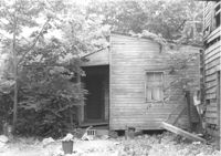
House-like structure in dilapidated condition (side view) on site affected by the construction of Interstate 26 (I-26). Dirt lot in foreground. Address: 739 Meeting Street. Surveyor notations on back of photo: "Dkt.: 10.503. Property owner: Eula Chitwood. Tract: 61. Station: 5909+30 Rt. Date: Feb. 20, 1963. In R/W - Bought." [See collection description for explanation of surveyor notations.]
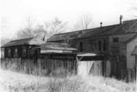
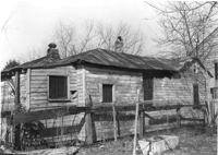
Houses (freedman's cottages) on site affected by the construction of Interstate 26 (I-26). Address: 12-14 Riker Street. Surveyor notations on back of photo: "Dkt.: 10.503. Property owner: Jesse Williams. Tract: 62. Station: 5910+40 Lt. Date: Feb. 20, 1963. In R/W - Bought." [See collection description for explanation of surveyor notations.]
Houses (freedman's cottages) (rear view) on site affected by the construction of Interstate 26 (I-26). Address: 12-14 Riker Street. Surveyor notations on back of photo: "Dkt.: 10.503. Property owner: Jesse Williams. Tract: 62. Station: 5910+40 Lt. Date: Feb. 20, 1963. In R/W - Bought." [See collection description for explanation of surveyor notations.]
House (freedman's cottage) (rear view) on site affected by the construction of Interstate 26 (I-26). Address: 16 Riker Street. Surveyor notations on back of photo: "Dkt.: 10.503. Property owner: Mary M. Polite, Est. Tract: 63. Station: 5910+50 Lt. Date: Feb. 20, 1963. In R/W - Bought." [See collection description for explanation of surveyor notations.]
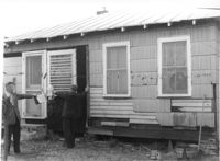
House (freedman's cottage) on site affected by the construction of Interstate 26 (I-26). Address: 16 Riker Street. Surveyor notations on back of photo: "Dkt.: 10.503. Property owner: Mary M. Polite, Est. Tract: 63. Station: 5910+50 Lt. Date: Feb. 20, 1963. In R/W - Bought." [See collection description for explanation of surveyor notations.]
Lot on site affected by the construction of Interstate 26 (I-26). Address: behind 12-14 Riker Street, which can be seen in the background. Surveyor notations on back of photo: "Dkt.: 10.503. Property owner: Katie C. Solomons. Tract: 62-A. Station: 5910+40 Lt. Date: Feb. 20, 1963. Buy fence & slat shed." [See collection description for explanation of surveyor notations.]
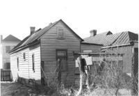
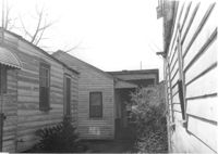
House (freedman's cottage) (rear view) on site affected by the construction of Interstate 26 (I-26). Address: 18 Riker Street. Fence and outbuilding in foreground. Surveyor notations on back of photo: "Dkt.: 10.503. Property owner: Mary Bradford, Est. Tract: 64. Station: 5910+40 Rt. & Lt. CL. Date: Feb. 20, 1963. In R/W - Bought." [See collection description for explanation of surveyor notations.]
House (freedman's cottage) on site affected by the construction of Interstate 26 (I-26). Address: 18 Riker Street. Surveyor notations on back of photo: "Dkt.: 10.503. Property owner: Mary Bradford, Est. Tract: 64. Station: 5910+40 Rt. & Lt. CL. Date: Feb. 20, 1963. In R/W - Bought." [See collection description for explanation of surveyor notations.]
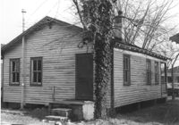
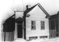
House (freedman's cottage) on site affected by the construction of Interstate 26 (I-26). Address: 24 Riker Street. Surveyor notations on back of photo: "Dkt.: 10.503. Property owner: Ethel Middleton. Tract: 65. Station: 5910+55 Rt. Date: Feb. 20, 1963. In R/W - Bought." [See collection description for explanation of surveyor notations.]
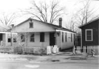
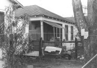
House on site affected by the construction of the Crosstown. Address: 100 Sheppard Street. Surveyor notations on back of photo: "Dkt.: 10.518. Property owner: M.J. Christine Butt, Est. Tract: 19. Station: 29+40 to 29+75 Lt. Sheppard Street. Date: Mar. 6, 1963. In R/W - Bought. [See collection description for explanation of surveyor notations.]
House (freedman's cottage) on site affected by the construction of Interstate 26 (I-26). Address: 24 Riker Street. Surveyor notations on back of photo: "Dkt.: 10.503. Property owner: Ethel Middleton. Tract: 65. Station: 5910+55 Rt. Date: Feb. 20, 1963. In R/W - Bought." [See collection description for explanation of surveyor notations.]
House (freedman's cottage) on site affected by the construction of Interstate 26 (I-26). Address: 24 Riker Street. Surveyor notations on back of photo: "Dkt.: 10.503. Property owner: Ethel Middleton. Tract: 65. Station: 5910+55 Rt. Date: May 30, 1963. In R/W - Bought." [See collection description for explanation of surveyor notations.]
House (freedman's cottage) (side view) on site affected by the construction of Interstate 26 (I-26). Address: 24 Riker Street. Surveyor notations on back of photo: "Dkt.: 10.503. Property owner: Ethel Middleton. Tract: 65. Station: 5910+55 Rt. Date: May 30, 1963. In R/W - Bought." [See collection description for explanation of surveyor notations.]
House (rear view) on site affected by the construction of Interstate 26 (I-26). Address: 22 Riker Street. Surveyor notations on back of photo: "Dkt.: 10.503. Property owner: Gibbs Mitchell, Est. Tract: 66. Station: 5910+50 Rt. Date: Feb. 20, 1963. In R/W - Bought." [See collection description for explanation of surveyor notations.]
House on site affected by the construction of Interstate 26 (I-26). Address: 22 Riker Street. Surveyor notations on back of photo: "Dkt.: 10.503. Property owner: Gibbs Mitchell, Est. Tract: 66. Station: 5910+50 Rt. Date: Feb. 20, 1963. In R/W - Bought." [See collection description for explanation of surveyor notations.]
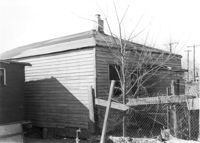
House (side view) on site affected by the construction of Interstate 26 (I-26). Address: 22 Riker Street (rear). Surveyor notations on back of photo: "Dkt.: 10.503. Property owner: Gibbs Mitchell, Est. Tract: 66. Station: 5910+00 Rt. Date: Feb. 20, 1963. In R/W - Bought." [See collection description for explanation of surveyor notations.]
House on site affected by the construction of Interstate 26 (I-26). Address: 22 Riker Street (rear). Surveyor notations on back of photo: "Dkt.: 10.503. Property owner: Gibbs Mitchell, Est. Tract: 66. Station: 5910+00 Rt. Date: Feb. 20, 1963. In R/W - Bought." [See collection description for explanation of surveyor notations.]
House on site affected by the construction of Interstate 26 (I-26). Address: 26 Riker Street. Surveyor notations on back of photo: "Dkt.: 10.503. Property owner: Julius S. Dennis. Tract: 67. Station: 5911+50 Rt. Date: Feb. 20, 1963. In R/W - Bought." [See collection description for explanation of surveyor notations.]
House (rear view) on site affected by the construction of Interstate 26 (I-26). Address: 26 Riker Street. Surveyor notations on back of photo: "Dkt.: 10.503. Property owner: Julius S. Dennis. Tract: 67. Station: 5911+50 Rt. Date: Feb. 20, 1963. In R/W - Bought." [See collection description for explanation of surveyor notations.]
House (freedman's cottage) on site affected by the construction of Interstate 26 (I-26). Address: 23 Riker Street. Surveyor notations on back of photo: "Dkt.: 10.503. Property owner: Lucille Williams. Tract: 68. Station: 5911+35 Rt. Date: Feb. 20, 1963. In R/W - Bought." [See collection description for explanation of surveyor notations.]
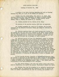
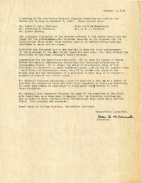
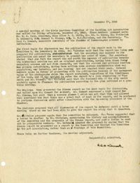
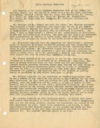
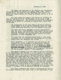
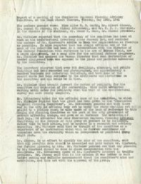
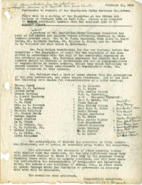
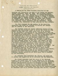
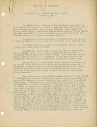
Memorandum from Samuel G. Stoney to other CSC members about the Hebrew Orphan Asylum (88-92 Broad Street) and the Ramsay House, "nothing imminent with regard to any change" (Jan. 20, 1947).
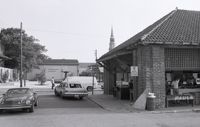
Renken Boat Co, on site affected by the widening of Route 171 (Folly Road). Surveyor notations on back of photo: "Dkt.: 10.494. Property owner: Renken Finance Co. Tract: 19. Station: 157+00 Lt. Date: Mar. 21, 1962. Proximity. [See collection description for explanation of surveyor notations.]
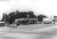
Shell gas station, on site affected by the widening of State Road 13 (Remount Road). Surveyor notations on back of photo: "Dkt.: 10.562. Property owner: Shell Oil Co., Inc. Tract: 2. Date: Jul. 12, 1967." [See collection description for explanation of surveyor notations.]
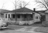
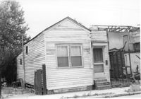
House on site affected by the construction of the Crosstown. Address: 98 Sheppard Street. Surveyor notations on back of photo: "Dkt.: 10.518. Property owner: M.J. Christine Butt, Est. Tract: 19. Station: 29+75 Lt. Sheppard Street. Date: Mar. 6, 1963. In R/W - Bought. [See collection description for explanation of surveyor notations.]
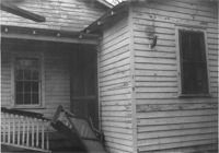
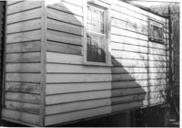
Exterior wall of freedman's cottage on site affected by the construction of Interstate 26 (I-26). Address: 23 Riker Street. Surveyor notations on back of photo: "Dkt.: 10.503. Property owner: Lucille Williams. Tract: 68. Station: 5911+35 Rt. Date: Feb. 20, 1963. In R/W - Bought." [See collection description for explanation of surveyor notations.]
House (freedman's cottage) on site affected by the construction of Interstate 26 (I-26). Address: 23 Riker Street. Surveyor notations on back of photo: "Dkt.: 10.503. Property owner: Lucille Williams. Tract: 68. Station: 5911+40 Rt. Date: May 30, 1963. In R/W - Bought." [See collection description for explanation of surveyor notations.]
House (freedman's cottage) on site affected by the construction of Interstate 26 (I-26). Address: 23 Riker Street. Surveyor notations on back of photo: "Dkt.: 10.503. Property owner: Lucille Williams. Tract: 68. Station: 5911+40 Rt. Date: May 30, 1963. In R/W - Bought." [See collection description for explanation of surveyor notations.]
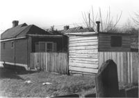
Structure at rear(?) of house on site affected by the construction of Interstate 26 (I-26). Address: 23 Riker Street (rear). Surveyor notations on back of photo: "Dkt.: 10.503. Property owner: Lucille Williams. Tract: 68. Station: 5911+40 Lt. Date: May 30, 1963. In R/W - Bought." [See collection description for explanation of surveyor notations.]
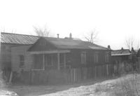
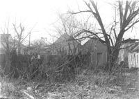
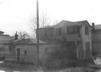
Dwellings on site affected by the construction of Interstate 26 (I-26). Address: 23 Riker Street (rear). Surveyor notations on back of photo: "Dkt.: 10.503. Property owner: Lucille Williams. Tract: 68. Station: 5911+85 Rt. Date: Feb. 20, 1963. In R/W - Bought." [See collection description for explanation of surveyor notations.]
Dwellings on site affected by the construction of Interstate 26 (I-26). Address: 23 Riker Street (rear). Surveyor notations on back of photo: "Dkt.: 10.503. Property owner: Lucille Williams. Tract: 68. Station: 5911+85 Rt. Date: Feb. 20, 1963. In R/W - Bought." [See collection description for explanation of surveyor notations.]