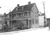
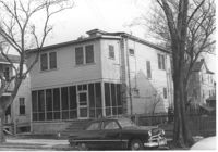
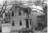
House on site affected by the construction of the Crosstown. Address: 57 Lee Street. Surveyor notations on back of photo: "Dkt.: 10.518. Property owner: Augustus G. Purvis. Tract: 49. Station: 45+05 Lt. N.B. lane Route 17. Date: Mar. 6, 1963. In R/W - Bought." [See collection description for explanation of surveyor notations.]
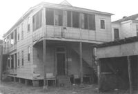
House (corner view, rear) on site affected by the construction of Interstate 26 (I-26). Address: 268 St. Philip Street. Surveyor notations on back of photo: "Dkt.: 10.517. Property owner: Sara Fox. Tract: 113. Station: 25+20 Rt. Southbound Lane Route 17. Date: March 5, 1963. In R/W - Bought." [See collection description for explanation of surveyor notations.]
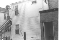
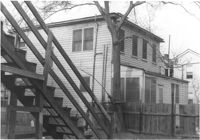
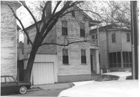
House (rear view) on site affected by the construction of Interstate 26 (I-26). Address: 270 St. Philip Street. Surveyor notations on back of photo: "Dkt.: 10.517. Property owner: William H. Steedley. Tract: 114. Station: 25+40 Rt. Southbound Lane Route 17. Date: March 5, 1963. In R/W - Bought." [See collection description for explanation of surveyor notations.]
House on site affected by the construction of Interstate 26 (I-26). Address: 270 St. Philip Street. Surveyor notations on back of photo: "Dkt.: 10.517. Property owner: William H. Steedley. Tract: 114. Station: 25+40 Rt. Southbound Lane Route 17. Date: March 5, 1963. In R/W - Bought." [See collection description for explanation of surveyor notations.]
House on site affected by the construction of Interstate 26 (I-26). Address: 69 Fishburne Street. Surveyor notations on back of photo: "Dkt.: 10.517. Property owner: Ben F. Yancy, et al. Tract: 116. Station: 26+30 CL Southbound Lane Route 17. Date: March 5, 1963. In R/W - Bought." [See collection description for explanation of surveyor notations.]
House (corner view, rear) on site affected by the construction of Interstate 26 (I-26). Address: 69 Fishburne Street. Surveyor notations on back of photo: "Dkt.: 10.517. Property owner: Ben F. Yancy, et al. Tract: 116. Station: 26+30 CL Southbound Lane Route 17. Date: March 5, 1963. In R/W - Bought." [See collection description for explanation of surveyor notations.]
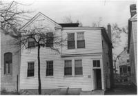
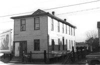
House on site affected by the construction of Interstate 26 (I-26). Address: 68 Fishburne Street. Surveyor notations on back of photo: "Dkt.: 10.517. Property owner: Annie F. Moessner. Tract: 117. Station: 26+55 Lt. Southbound Lane Route 17. Date: March 5, 1963. Proximity." [See collection description for explanation of surveyor notations.]
House on site affected by the construction of the Crosstown. Address: 55 Lee Street. Surveyor notations on back of photo: "Dkt.: 10.518. Property owner: Augustus G. Purvis. Tract: 49. Station: 45+55 Lt. N.B. lane Route 17. Date: Mar. 6, 1963. In R/W - Bought." [See collection description for explanation of surveyor notations.]
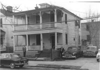
House on site affected by the construction of Interstate 26 (I-26). Address: 67 Fishburne Street. Surveyor notations on back of photo: "Dkt.: 10.517. Property owner: H.H. Rabens. Tract: 119 & 120. Station: 26+60 CL Southbound Lane Route 17. Date: March 5, 1963. In R/W - Bought." [See collection description for explanation of surveyor notations.]
House on site affected by the construction of Interstate 26 (I-26). Address: 67 Fishburne Street. Surveyor notations on back of photo: "Dkt.: 10.517. Property owner: H.H. Rabens. Tract: 119 & 120. Station: 26+60 CL Southbound Lane Route 17. Date: March 5, 1963. In R/W - Bought." [See collection description for explanation of surveyor notations.]
Right of way--South Carolina--Charleston County, Highway planning--South Carolina--Charleston County, Vernacular architecture--South Carolina--Charleston County, Lost architecture--South Carolina--Charleston County, Dwellings--South Carolina--Charleston County✖[remove]1,563