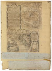
Page 207 of the City Engineer's Plat Book with two plats. Plat 1 is titled "The Plan of Charles Town With its Entrenchments and those made during the Siege by the English 1780," and shows Queen Street, Church Street, Tradd Street, King Street, Broad Street, the State House, the Market, the Arsenal, an "Old Church" and a "New Church." It also shows certain geographic features, including "Cummins Point," Cannons Point, and Hampstead Hill. Plat 2 has a label reading "This Map In every particular copied with a Pen from an Old Plat of Charles Town dated 1671 found in a Book of Plats of various parts of U.S.A. printed in London 1671." Plat 2 shows several geographic features such as rivers and islands, and features numerous illustrations. The largest illustration depicts two groups of people interacting from either side of a stream. Each group holds a single spear.
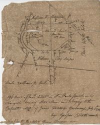
196 acres of land located in St Pauls Parish on a navigable branch of Stono River amd belonging to the confiscated estate of James D. Yarborough. Names associated with this plat include Thomas Ferguson, James Yarborough, G. Trotti, William Williamson, Charles Elliot, William Clay Snipes, Thomas Broughton, Edmond Bellinger, and Thomas Cliffon. Notable geographic locations include St. Paul's Parish, the Stono River, Road to Willows, Rutledge’s Creek, Road to Pon Pon and Jacksonborough.
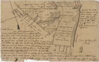
120 acre plot purchased by George Rivers, shows Bohicket Creek and several smaller creeks, also denotes some marsh, highland, and riverbanks, the plot of land is divided into six smaller plots with "Broad Road" running between them. Names associated with this plat are John Rivers, Dr. Micah Jenkins, James Stanyon, George Rivers, Hearn, Matthews, Solomon Freer, William Spencer, James Rivers, John Taylor, Margaret Simpson, William Holmes, John Holmes and James Legare. Notable geographic locations are Bohicket Creek, Johns Island, and Colleton County.