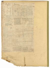
Page 12 of the City Engineer's Plat Book with two plats. Plat 1 shows plots near Coming Street, St. Phillip Street, King Street, Meeting Street, and Vanderhorst Street. Plat 2 Shows lots on Queen Street near the intersections with East Bay Street and Prioleau Street, has the label "Charleston Harbour Cooper River" on the right-hand margin.
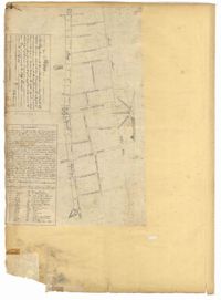
Page 14 of the City Engineer's Plat Book with one plat. The plat shows land between Bay Street and Church Street, including stretches of Tradd Street, Broad Street, and Queen Street.
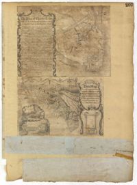
Page 207 of the City Engineer's Plat Book with two plats. Plat 1 is titled "The Plan of Charles Town With its Entrenchments and those made during the Siege by the English 1780," and shows Queen Street, Church Street, Tradd Street, King Street, Broad Street, the State House, the Market, the Arsenal, an "Old Church" and a "New Church." It also shows certain geographic features, including "Cummins Point," Cannons Point, and Hampstead Hill. Plat 2 has a label reading "This Map In every particular copied with a Pen from an Old Plat of Charles Town dated 1671 found in a Book of Plats of various parts of U.S.A. printed in London 1671." Plat 2 shows several geographic features such as rivers and islands, and features numerous illustrations. The largest illustration depicts two groups of people interacting from either side of a stream. Each group holds a single spear.
876 acres of land west of Murray Road in St. John's Parish. Names associated with this plat are Chas Johnston, Ben Castell, William Simpson, Verth, and J.G. Wiare. Notable geographic locations include Wadboo Barony.
Plat of land of 64 acres laid out for Allard Belin situated on Sandy Island. Names associated with this plat are Allard Berlin, John Hardwick and D.T. Waring.
Copy of plan of a plantation on Stono Swamp commonly called Stono Plantation belonging to Thomas Ferguson. Contains 630 acres. Approximately 360 acres is swamp and approximately 270 acres is highland. Names associated with this plat are Thomas Ferguson, George Haig, Joseph Farr, Mary Williams, Smith and John McSweeney. Notable geographic locations include Stono Swamp, Stono Plantation and Charleston.
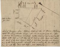
Copy of tract of land containing 200 acres, butting and bounding south and west by William Elliott, and on the east by Clay, and to the north by John Rivers. Names associated with this plat include William Webb, Thomas Mellichamp, Butler, William Elliott, William Clay, Shem, John Rivers, John S. Cripps, Samuel Jones, the Lords Proprietors, and Daniel Gibson.