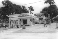
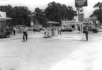
Gulf gas station, on site affected by the widening of State Road 13 (Remount Road). Surveyor notations on back of photo: "Dkt.: 10.562. Property owner: E.R. Gassman. Tract: 1. Date: Jul. 12, 1967." [See collection description for explanation of surveyor notations.]
Gulf gas station, on site affected by the widening of State Road 13 (Remount Road). Arrow Restaurant and Trucker's Billiard Academy across the street. Surveyor notations on back of photo: "Dkt.: 10.562. Property owner: E.R. Gassman. Tract: 1. Date: Jul. 12, 1967." [See collection description for explanation of surveyor notations.]
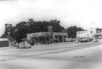
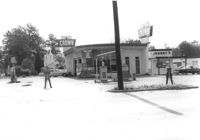
Shell gas station, on site affected by the widening of State Road 13 (Remount Road). Surveyor notations on back of photo: "Dkt.: 10.562. Property owner: Shell Oil Co., Inc. Tract: 2. Date: Jul. 12, 1967." [See collection description for explanation of surveyor notations.]
Shell gas station, on site affected by the widening of State Road 13 (Remount Road). Arrow Restaurant in background. Surveyor notations on back of photo: "Dkt.: 10.562. Property owner: Shell Oil Co., Inc. Tract: 2. Date: Jul. 12, 1967." [See collection description for explanation of surveyor notations.]
Shell gas station, on site affected by the widening of State Road 13 (Remount Road). Gulf gas Station: across the street. Surveyor notations on back of photo: "Dkt.: 10.562. Property owner: Shell Oil Co., Inc. Tract: 2. Date: Jul. 12, 1967." [See collection description for explanation of surveyor notations.]
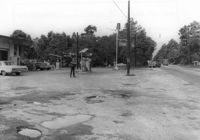
Crown gas station, on site affected by the widening of State Road 13 (Remount Road). Johnny's in back. Possibly the corner of North Rhett Avenue and Remount Road. Surveyor notations on back of photo: "Dkt.: 10.562. Property owner: Corco Realty Co. (Crown). Tract: 142. Date: Jul. 19, 1967." [See collection description for explanation of surveyor notations.]
Crown gas station, on site affected by the widening of State Road 13 (Remount Road). Possibly the corner of North Rhett Avenue and Remount Road. Surveyor notations on back of photo: "Dkt.: 10.562. Property owner: Corco Realty Co. (Crown). Tract: 142. Date: Jul. 19, 1967." [See collection description for explanation of surveyor notations.]
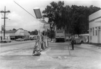
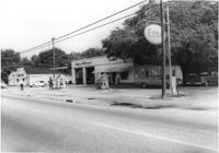
Esso gas station, on site affected by the widening of State Road 13 (Remount Road). Louie's Speed shop in background. Surveyor notations on back of photo: "Dkt.: 10.562. Property owner: Harry R. Williams. Tract: 113. Date: Jul. 19, 1967." [See collection description for explanation of surveyor notations.]
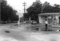
Atlantic gas station, on site affected by the widening of State Road 13 (Remount Road). Surveyor notations on back of photo: "Dkt.: 10.562. Property owner: Atlantic Refining Co. Tract: 37. Date: Jul. 19, 1967." [See collection description for explanation of surveyor notations.]
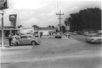
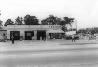
Texaco gas station, on site affected by the widening of State Road 13 (Remount Road). Surveyor notations on back of photo: "Dkt.: 10.562. Property owner: W.L. Dyches, et al. Tract: 23. Date: Jul. 12, 1967." [See collection description for explanation of surveyor notations.]
Right of way--South Carolina--Charleston County, Highway planning--South Carolina--Charleston County, Commercial buildings--South Carolina--Charleston County, Service stations--South Carolina--Charleston County, Vernacular architecture--South Carolina--Charleston County, Lost architecture--South Carolina--Charleston County✖[remove]19
Charleston County (S.C.)--Buildings, structures, etc.✖[remove]19