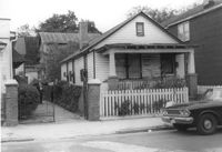
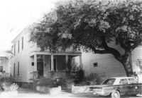
House on site affected by the construction of the Crosstown. Address: 127 Bogard Street. Surveyor notations on back of photo: "Dkt.: 10.524. Property owner: Lucille Frasier. Tract: 46. Station: 72+40 Lt. Date: Oct. 14, 1964. Portion In R/W - Bought." [See collection description for explanation of surveyor notations.]
House on site affected by the construction of the Crosstown. Address: 127 Bogard Street. Surveyor notations on back of photo: "Dkt.: 10.524. Property owner: Lucille Frasier. Tract: 46. Station: 72+40 Lt. Date: Oct. 14, 1964. Portion In R/W - Bought." [See collection description for explanation of surveyor notations.]
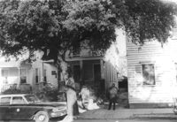
House on site affected by the construction of the Crosstown. Address: 16 Todd Street. View of street corner (corner of Todd Street and Sheppard Street). Surveyor notations on back of photo: "Dkt.: 10.524. Property owner: Wilmot J. Frasier. Tract: 125. Station: 88+80 Lt. Date: Dec. 2, 1964. In R/W - Bought." [See collection description for explanation of surveyor notations.]
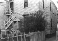
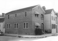
Rear view of house on site affected by the construction of the Crosstown. Address: 508 Rutledge Avenue. Surveyor notations on back of photo: "Dkt.: 10.524. Property owner: W.C. Hayes, Est. Tract: 112. Station: 86+60 Lt. Date: Dec. 1, 1964. In R/W - Bought." [See collection description for explanation of surveyor notations.]
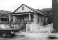
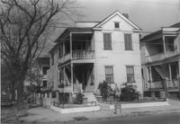
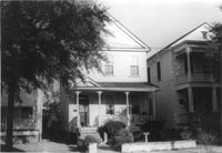
House on site affected by the construction of the Crosstown. Address: 504 Rutledge Avenue. Surveyor notations on back of photo: "Dkt.: 10.524. Property owner: Florence Britton Jones. Tract: 114. Station: 86+30 Rt. Date: Dec. 1, 1964. In R/W - Bought." [See collection description for explanation of surveyor notations.]
House on site affected by the construction of the Crosstown. Address: 504 Rutledge Avenue. Surveyor notations on back of photo: "Dkt.: 10.524. Property owner: Florence Britton Jones. Tract: 114. Station: 86+30 Rt. Date: Dec. 1, 1964. In R/W - Bought." [See collection description for explanation of surveyor notations.]
House on site affected by the construction of the Crosstown. Address: 16 Todd Street. View of street corner (corner of Todd Street and Sheppard Street). Surveyor notations on back of photo: "Dkt.: 10.524. Property owner: Wilmot J. Frasier. Tract: 125. Station: 88+80 Lt. Date: Dec. 2, 1964. In R/W - Bought." [See collection description for explanation of surveyor notations.]
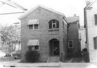
House on site affected by the construction of the Crosstown. Address: 120 Sheppard Street. View of street corner. Surveyor notations on back of photo: "Dkt.: 10.524. Property owner: Jackson T. Rhodes. Tract: 142. Station: 18+25 Lt. S.B. lane. Date: Dec. 2, 1964. Condemned." [See collection description for explanation of surveyor notations.]
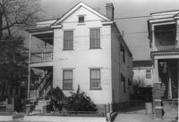
House on site affected by the construction of the Crosstown. Address: 506 Rutledge Avenue. Surveyor notations on back of photo: "Dkt.: 10.524. Property owner: Stephen B. Graham, et al. Tract: 113. Station: 86+50 Lt. Date: Dec. 1, 1964. In R/W - Bought." [See collection description for explanation of surveyor notations.]
House on site affected by the construction of the Crosstown. Address: 120 Sheppard Street. Surveyor notations on back of photo: "Dkt.: 10.524. Property owner: Jackson T. Rhodes. Tract: 142. Station: 18+25 Lt. S.B. lane. Date: Dec. 2, 1964. Condemned." [See collection description for explanation of surveyor notations.]
Right of way--South Carolina--Charleston County, Highway planning--South Carolina--Charleston County, Vernacular architecture--South Carolina--Charleston County, Lost architecture--South Carolina--Charleston County, Dwellings--South Carolina--Charleston County✖[remove]287