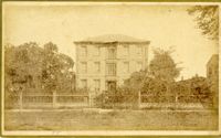
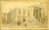
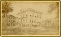
Caption: 'Cook's Earthquake Views of Charleston and Vicinity. Taken after the 31st of August, 1886. No.66, _____ Alston, East Battery.' Charleston city directory for 1886 shows various members of the Alston family at 21 East Battery.
Caption: 'Cook's Earthquake Views of Charleston and Vicinity. Taken after the 31st of August, 1886. No.36, Court House, City Hall, and Fireproof Building.'
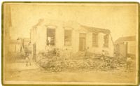
Caption: 'Cook's Earthquake Views of Charleston and Vicinity. Taken after the 31st of August, 1886. No.93, No.11 King Street.' Written on front, at bottom: 'Charleston Earthquake scene - Private residence on King St. near South Battery.'
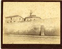
Caption: 'Charleston Earthquake. Photographs by Dr. E.P. Howland, taken on his visit to Charleston and the earthquake region of Ten Mile Hill and Summerville. Over 150 Photographs were taken. Charleston Jail and cracked wall, unsafe and condemned.'
Caption: 'Cook's Earthquake Views of Charleston and Vicinity. Taken after the 31st of August, 1886. No.12, Citadel Academy.' Shows Citadel when located on Marion Square.
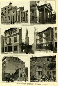
Caption: 'The Ruins Of Charleston.--photographed by W.E. Wilson, Savannah, Georgia. 1. The Guard House. 2. St. Michael's Church. 3. News and Courier Office. 4. St. Philip's Church. 5. No.27 Broad Street. 6. Hibernian Hall. 7. The Medical College.'
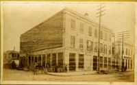
Caption: 'Cook's Earthquake Views of Charleston and Vicinity. Taken after the 31st of August, 1886. No.136, Meeting Street, cor. [of] Market.' Henry Steitz Produce is pictured. Charleston City directory for 1886 lists Henry Steitz, Fruits & Produce, at 113-115 Market Street.
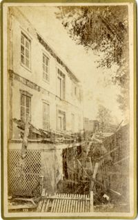
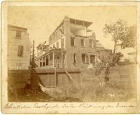
Caption: 'Charleston Earthquake. Photographs by Dr. E.P. Howland, taken on his visit to Charleston and the earthquake region of Ten Mile Hill and Summervile. Over 150 Photographs were taken. House of Mrs. Snowden, President of Confederate Home.'
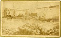
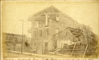
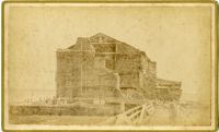
Caption: ' Cook's Earthquake Views of Charleston and Vicinity. Series No.2. No.164, Storehouse of Bennett's Mill.' Note on the catalog card show storehouse located at East end of Wentworth Street.
Caption: 'Cook's Earthquake Views of Charleston and Vicinity. Taken after the 31st of August, 1886. No.61, Mrs. B.D. Lazarus, Hasel [sic] St.' Charleston city directory for 1886 shows Mrs. B.D. Lazarus at 64 Hassell Street.
Caption: 'Cook's Earthquake Views of Charleston and Vicinity. Taken after the 31st of August, 1886. No. 55, Major R.C. Gilchrist, Bee St[reet].' Charleston city directory for 1886 shows Robert C. Gilchrist at 12 Bee Street.
Caption: 'Cook's Earthquake Views of Charleston and Vicinity. Series No.2. No.190, Kerr's Wharf. Charleston city directory for 1886 lists Kerr's Wharf as opposite Cordes.
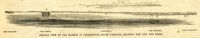
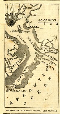
Caption: 'Profile view of the harbor of Charleston, South Carolina, showing the city and forts.' Identified in the image: Fort Johnston (sic), Fort Sumter, Charleston, Fort Moultrie and Mount Pleasant. [full date December 29, 1860.]
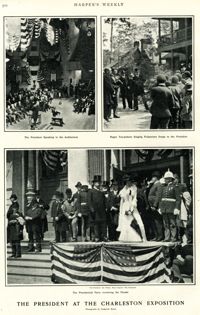
Main caption: 'The President at the Charleston Exposition. Photographs by Frederick Moore.' Caption top left: 'The President speaking in the auditorium.' Caption top right: 'Negro tea-pickers singing pickaninny songs to the President.' Caption bottom center: 'The presidential party reviewing the parade.' Further captioning identifies: 'The President, Sec. Wilson, Mayor Smythe, Mrs. Roosevelt.'
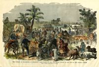
[Color image.] Caption: 'The citizens of Charleston, S.C., deserting their homes, on the threatened attack of the city by the Federal Forces. From a Sketch by Lieutenant G.P. Kirby.'
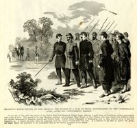
Caption: 'Escorting Major Taylor, of New Orleans, the bearer of a flag of truce, blindfolded, to the Confederate lines, after his unsuccessful mission.'
Caption: 'Cook's Earthqauke Views of Charleston and Vicinity. Taken after the 31st of August, 1886. No.126, East Bay, corner Queen Street.' Sign on building reads: 'Ship & Family Groceries.' Possibly J.J.W. Luden, retail grocers and ship chandlers, located 167-169 East Bay, according to the 1886 Charleston city directory.
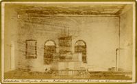
Caption: Cook's Earthquake View of Charleston and Vicinity. Taken after the 31st of August, 1886. No.151, Mariner's Church, interior.' Also, handwritten at bottom, front: 'Charleston Earthquake scene - Interior of Mariners' Church, on Church Street.'
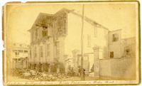
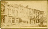
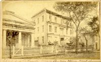
Caption: 'Cook's Earthquake Views of Charleston and Vicinity. Taken after the 31st of August, 1886. No.22, Broad Street, north side.' Charleston Insurance & Trust, Co. is shown to the left. Charleston city directory for 1886 lists it as Ravenel, Johnson & Co. at 12 Broad Street.
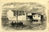
Caption: 'The Floating Battery at Charleston, S.C., intended to assist in the capture of Fort Sumpter (sic), with Dr. De Vega's hospital attached.--from a sketch by our Special Artist in Charleston.--see page 289.' [full date March 30, 1861.]
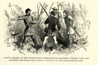
Caption: 'Captain Frazer, of the Twenty-First Massachusetts Regiment, turning upon and capturing his guard while being conveyed to the Confederate camp.'
![[Elliott Street]](https://iiif.library.cofc.edu/iiif/2/50708/full/200,/0/default.jpg)