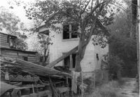
Rear view of house on site affected by the construction of the Crosstown. Address: 5 Rosemont Street (rear). Backyard strewn with wood boards, etc. Surveyor notations on back of photo: "Dkt.: 10.524. Property owner: Harold I. Sherman. Tract: 53. Station: 71+70 Rt. Date: Oct. 14, 1964. In R/W - Bought." [See collection description for explanation of surveyor notations.]
House (rear view) on site affected by the construction of the Crosstown. Address: 152-150 Line Street. Surveyor notations on back of photo: "Dkt.: 10.524. Property owner: John N. Peeksen. Tract: 117. Station: 86+70 Rt. Date: Dec. 1, 1964. In R/W." [See collection description for explanation of surveyor notations.]
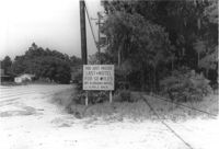
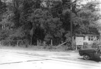
Lot on site affected by the widening of U.S. Route 17. Posted sign says: You just passed last motel for 50 miles, Mt. Pleasant Motel, ¼ mile back. Presumably located in Mount Pleasant or vicinity. Surveyor notations on back of photo: "Dkt.: 10.439. Property owner: Charleston County Public Works. Tract: 12. Station: 239+45 to 243+73 Rt. Date: Jul. 22, 1965. Range poles on 50' R/W & fence on 33' R/W - Cond." [See collection description for explanation of surveyor notations.]
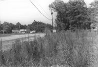
Lot on site affected by the widening of U.S. Route 17. Posted sign says: Speed checked by radar. Presumably located in Mount Pleasant or vicinity. Surveyor notations on back of photo: "Dkt.: 10.439. Property owner: Francis F. Coleman, et al. Tract: 13. Station: 245+50 Rt. Date: Jul. 22, 1965. Range poles on 33' & 50' R/W showing house (portion)." [See collection description for explanation of surveyor notations.]
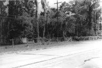
Lot on site affected by the widening of U.S. Route 17. Presumably located in Mount Pleasant or vicinity. Surveyor notations on back of photo: "Dkt.: 10.439. Property owner: Charleston County Public Works. Tract: 12. Station: 239+45 to 243+73 Rt. Date: Jul. 22, 1965. Looking from the east at range poles on 50' R/W & fence on 33' R/W - Cond." [See collection description for explanation of surveyor notations.]
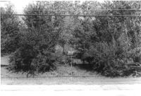
Lot on site affected by the widening of U.S. Route 17. Presumably located in Mount Pleasant or vicinity. Surveyor notations on back of photo: "Dkt.: 10.439. Property owner: Charleston Oil Co. Tract: 11. Station: 237+26 to 239+45 Rt. Date: Jul. 22, 1965. Range poles on 33' & 50' R/W - Cond." [See collection description for explanation of surveyor notations.]
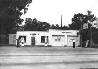
Humble gas station / Esso gas station on site affected by the widening of U.S. Route 17. Ed Cummings, proprietor. Presumably located in Mount Pleasant or vicinity. Surveyor notations on back of photo: "Dkt.: 10.597. Property owner: Edward Cummings. Tract: 37. Station: 285+20 Lt. Date: Sept. 17, 1968." [See collection description for explanation of surveyor notations.]
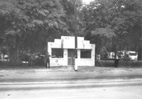
Building on site affected by the widening of U.S. Route 17. Front facade has stepped parapet. Appears to have previously been a business. Presumably located in Mount Pleasant or vicinity. Surveyor notations on back of photo: "Dkt.: 10.597. Property owner: Leon Burns, et al. Tract: 5. Station: 265± Lt. looking south. Date: Sept. 17, 1968." [See collection description for explanation of surveyor notations.]
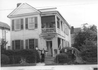
House on site affected by the construction of the Crosstown. Address: 195 Spring Street. Surveyor notations on back of photo: "Dkt.: 10.524. Property owner: Charlotte M. and John Pembroke. Tract: 12. Station: 23+40 Rt. (Spring Street). Date: Oct. 13, 1964. Steps to be removed by property owner; wrought iron fence bought." [See collection description for explanation of surveyor notations.]
Lot on site affected by the widening of U.S. Route 17. Posted sign says: You just passed last motel for 50 miles, Mt. Pleasant Motel, ¼ mile back. Portion of house visible. Presumably located in Mount Pleasant or vicinity. Surveyor notations on back of photo: "Dkt.: 10.439. Property owner: Charleston County Public Works. Tract: 12. Station: 240+00 Rt. Date: Jul. 22, 1965. Looking from west at range poles on 50' R/W & fence on 33' R/W - Cond." [See collection description for explanation of surveyor notations.]