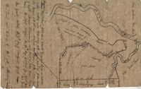
960 acres of land situated lying and being in Colleton County, butting and bounding to the north on part of John Seabrook's land to the east on Ashepoo River to the South on land of Captain Thomas Flemming and part of John Dears’ Land. Names associated with this plat are Benjamin Whitaker, Thomas Pinckney, Captain Thomas Flemming, John Seabrook, John Dear, Richard Woodward, John Hutchinson, John Godfrey, Samuel Larrington, James St. John, Godfrey, Elizabeth Woodward, William McPherson, Thomas M. Pinckney, and James M. Pinckney. Notable geographic locations are Ashepoo River, Dear's Creek and Colleton County.
Two small plats of land. One containing 200 acres of land laid out to Margaret Childs situated near the head of Weetee Branch. Bounding on the NE, NW, and SE, and West on vacant lands. Southwestardly on land formerly laid out to Daniel Gibbons. The second plat is 78 acres of land laid out to Robert Newman in Craven County bounding to the north of Orochone [?] and on all other sides by vacant land. Names associated with this plat are Daniel Gibbons, Robert Newman, James St. John, Thomas Broughton, and Margaret Childs. Notable geographic locations include Prince Frederick’s Parish, Georgetown district, Weetee River, and Christal [Crystal?] Spring.
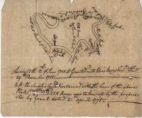
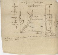
Plat of 222 acres granted to and acquired by Elias Horry on the Santee River. Names associated with this plat are Elias Horry and Izard. Names associated with this plat are Elias Horry and Izard. Notable geographic locations are Santee River, Toby Creek, Wild Hook Creek.
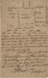
1000 acres granted to Elizabeth Jennings situated in Craven County about 14 miles above Lynch's Creek Ferry, about 3 miles below lands of Joseph Birch. Bounding to the SW on Pee Dee River, NW on John Stone's land, and on all other sides on lands not yet laid out. Names associated with this plat include A. Vanderhorst, Stone, Elizabeth Jennings, Elizabeth Raven, John Stone, George Pawley, Joseph Birch, Jasper St. John, Miniken and Hamilton. Notable geographic locations include the Pee Dee River, Craven County [now in parts of Berkeley, Charleston, Georgetown, and Williamsburg counties], and Lynch's Creek Ferry.
Copy of plat granted to John Atchison. "The plat annexed to the grant dated March 2, 1736." Names associated with this plat are John Atchison, James St. John, Thomas Broughton, J. Branch and Middleton. Notable geographic locations include Santee, Four Mile Creek, Santee River, and Cravens County [now in parts of Berkeley, Charleston, Georgetown, and Williamsburg counties].
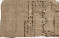
187 acres of land laid out for Walter Izard in Berkeley County butting and bounding North and West on lands of Francis Varnod, South on Thomas Waring lands and East on George Boons land. Names associated with this plat are Francis Varnod, Thomas Waring, Joseph Boone, Walter Izard, James St. John, and Robert Johnson. Notable geographic locations include St. George's Parish, Dorchester and Berkeley County.
Plat of 500 acres off of the Savannah River granted to James Sutherland in 1737. Detail includes a creek of the southern branch of the Savannah River and various trees on the property lines. Names associated with this plat are James Sutherland, Patrick McKay, and James Stobo. Notable geographic locations include St. Peters Parish, Savannah Lands, and the South Branch of a creek of the Savannah River.
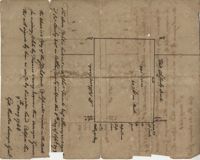
600 acres plot granted to Richard Floyd residing in Colleton County lying and budding on the southside of Bohickett Creek, shows surrounding property names and creeks, shows land notes but no land type or details. Also shown is 200 acres granted by the Lords Proprietors by William Arnell in Colleton County. Names associated with this plat are Richard Floyd, Graeme [?], the Lords Proprietors, Michael Ranell, Thomas Broughton, Robert Gibbes, William Atnel, Timothy Bellemey, Anthony Matthews, Ambross Hill, John Prescot and Neufville. Notable geographic locations include John's Island, Bohickett Creek, Colleton County, Ambrose Hill, Stono River, and Keywa [Kiawah] Island.
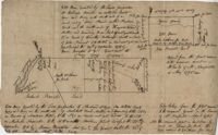
Plat of 500 acres in Colleton County. Very little detail included. Names associated with this plat are Alexander French, Thomas Clifford, Bettison, Francis Young, George Hunter, and John Bartys.
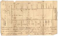
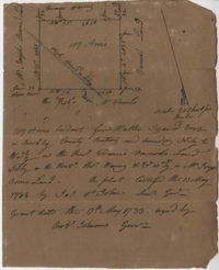
296 acres of land conveyed to Alexander Walker to John Sumer and M. Weston executors of the last will and testament of Richard Downs (1705). Names associated with this plat include Richard Downs, Smith, Joseph Stanyarn, Coats, Alexander Walker, John Sumer, Plowden Weston, Roper and Chrisby [?]. Notable geographic locations include Broad Road to Jacksonborough and Stono.
Limit your search
John McCrady Plats and Deeds Collection✖[remove]31