General Cutherbert's land on Big Pipe Creek. Names associated with this plat are General Cuthbert, B.H. Roberts, Ball, Peters and David DeSapah [?]. Notable geographic locations include the Savannah River.
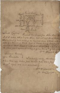
Copy of a plat of a tract of land containing 100 acres situated on the west side of branch of Black River in Craven County bounding on all sides on vacant land. Names associated with this plat are John Trough, James Bauman, Robert McDaniel, Gluscork [?], Howard, and Samuel Bunger. Geographic locations include Craven County [now in parts of Berkeley, Charleston, Georgetown, and Williamsburg counties], Black River, and Blues River.
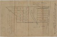
Copy of a plan of lots No.1-7, 9-11 on Cumberland Street in Charleston, Ward No.3. Indicates some buildings including a brick stable at No. 9 and DeBorr’s house and lot. “Lands of Mr. Edwards" is written above the lots. Names associated with this plat include De Borr, Edwards, and Charles Parker. Notable geographic locations include Church Street, Corr Alley or Philadelphia Street, Cumberland Street, and Ward Number 3.
1300 acres surveyed for James Bowman, no land type or detail, shows property boundaries and neighboring plots. Names associated with this plat are James Bowman, Morris, Oswald, Warley, E.B. Fishburn, Lindsey, and B.G.O. Bryan. Notable geographic locations include New road leading to Parkers Ferry [?].
Small description of a 264 acre land, near Wappoo Creek, including land description. Names associated with this plat are John Schnerlie, Thomas S. Jones, and Edwin R. Dorrill. Notable geographic locations include the Ashley River, Wappoo Creek, Ashley Bridge Ferry Road, and Charleston District.
Plat consists of 50 acres titled Newington Plantation bounding on Middleton Plantation. Names associated with this plat include Johnson Middleton, N.W. Ancrum, G.H. Ingraham, R.B. Pinckney and H.A. Middleton.
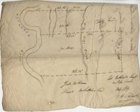
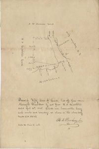
Pencil sketch of a plot of land that includes roads, creeks, and ponds, shows surrounding neighbors and little land detail. Names associated with this plat are Rich Jenkins. Notable geographic locations include Road to Bear Bluff and Wadmalaw River Marsh.
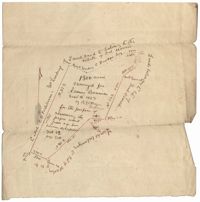
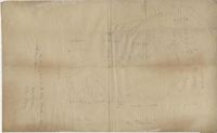
Plat of 1126 acres in St. James Goose Creek on Wasamasaw [Wassamassaw] Swamp. Plat is in pencil and is difficult to read the few details, although there are a few outlines of buildings included, but difficult to tell what they are. Names associated with this plat include Daniel Gelyer, J. Ferrels, Thomas Cusack [?], and James Haney. Notable geographic locations include Wasamasaw [Wassamassaw] Swamp, Sheep Island, Goose Creek, Road to Dorchester, and Ekells Branch.
Plat of 1199 acres in St. Johns Parish. Names associated with this plat are Daniel Gelyer, Peter Sanders, James Rown, Thompson, Meadwell, S. Brichelle [?] and Maun. Notable geographic locations include Berkeley.