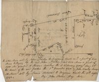
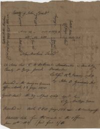
"Release from Thomas Osborn a Sheriff Charleston District to Philip Hart dated 6 October 1794 for a tract of land measuring and Containing 500 acres more or less situated lying and being on the Cypress Swamp in the district of Charleston Butting and Bounding Westwardly on land now or late the property of David Manll. Southwardly on lands of John Conard, Eastwardly on lands of Thomas Waring and Northeastwardly on lands belonging to Major James Postell - Sold under [?] in the property of William Doweth." Names associated with this plat are Thomas Osborn, William Dewitt, Hart, David Manll, John Conrad, Thomas Waring, Philip Hart, James Postell, and William Doweth. Notable geographic locations include St. George Parish, Cypress Swamp and Charleston District.
Plat of 380 acres on a great swamp near Coll. Pen Bay. Names associated with this plat are John Jones, Joseph Haynes, Lewis Oglesbee, M. Cattersloni [?], and John Rofe.
179 acre plot of land given to Mr. Webster, shows the property lines and no land type detail. Names associated with this plat include Webster, Peters, Branford, and John James Haig. Notable geographic locations include the Pon Pon River.
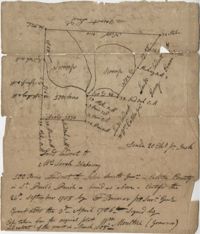
"Jonathan Burnbridge 310 acres certified for him the 24th day of December 1805. Pursuant to a warrant from Artemar B. Darby D. S. G. dated the 20th day of December 1805 having admeasured and laid out unto Jonathan Bunbridge a tract of land containing 310 acres situated in Charleston District bounded by a lain [sic] running NW and NW by land of Ralph Izard NE on land of William Stephens NE and E on land not known and by all other lines on land of Doctor William Stephens and hath such form and marks as the above plat represents Surveyed the 21 day of December 1805 Michael Byrne Dep Surveyor." Names associated with this plat are Jonathan Darby Bunbridge, B. Artemar, Ralph Izard, William Stepens, Dr. William Stephens, and Michael Byrne. Notable geographic locations include St. Bartholomew’s Parish.
Plat of 419 acres near Goose Creek sold to Benjamin Wood by John Parker. Only the trees located on the property line and names on neighboring property owners are included. Names associated with this plat are John Parker, Benjamin Wood, Thomas Barker, John Barley, James Boswood, Benjamin Woods, John Stevens, Thomas Hodson, I. Drayton, Thomas Mell, and Ben Godin.
Copy of a plat of 500 acres originally laid out to John Smith, now (1805) belonging to Alexander Bower as nephew and heir to the grantee. Details include swamps, surrounding lands, and trees. Names associated with this plat are Alexander Bower, John Smith, F. Bremar, William Moultrie, Sarah Blakeway, William Cattle, and Henry Crum.
Plat of 1,000 acres on Strawberry Bay granted to James Packer. The bay and marsh area is marked but there is little other detail included. Names associated with this plat include James Packer, William Sparkmon, James G. Ware, and W. Moultrie.
Copy of a plat of 200 acres on the neck of the Ashley River belonging to Thomas Butler. Only property outline and a few notes about the edges of the property are included. Names associated with this plat are Thomas Butler, Barker, John Bradford, and John Archdale. Notable geographic locations include the Ashley River, Clear Spring and St. Andrew's Parish.
Plat of 42 acres in St. George’s Parish belonging to Nathaniel Bradwell. Very little detail included with the plat. Names associated with this plat include Nathaniel Bradwell, John B. Giradeau, E.G. Montagu, John Barker, and Peter Haskins.
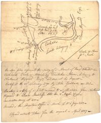
56 acre plot of land given to Radcliffe, the plot of land is bordering Cuckolds Creek, shows surrounding property owners, no land type detail or identification. Names associated with this plat are Thomas Radcliffe, Nathaniel Heyward, John Goddard and James Heyward. Notable geographic locations include Cuckolds Creek, Combahee River and St. Bartholomew's Parish.