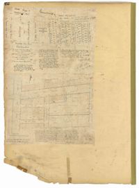
Page 12 of the City Engineer's Plat Book with two plats. Plat 1 shows plots near Coming Street, St. Phillip Street, King Street, Meeting Street, and Vanderhorst Street. Plat 2 Shows lots on Queen Street near the intersections with East Bay Street and Prioleau Street, has the label "Charleston Harbour Cooper River" on the right-hand margin.
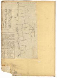
Page 14 of the City Engineer's Plat Book with one plat. The plat shows land between Bay Street and Church Street, including stretches of Tradd Street, Broad Street, and Queen Street.
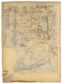
Page 70 of the City Engineer's Plat Book with two plats. Plat 1 shows lots located near the intersection of "Broad Road" and George Street, with several buildings and bodies of water. Plat 2 shows a mill pond, marshlands, and structures located near the Ashley River.
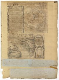
Page 207 of the City Engineer's Plat Book with two plats. Plat 1 is titled "The Plan of Charles Town With its Entrenchments and those made during the Siege by the English 1780," and shows Queen Street, Church Street, Tradd Street, King Street, Broad Street, the State House, the Market, the Arsenal, an "Old Church" and a "New Church." It also shows certain geographic features, including "Cummins Point," Cannons Point, and Hampstead Hill. Plat 2 has a label reading "This Map In every particular copied with a Pen from an Old Plat of Charles Town dated 1671 found in a Book of Plats of various parts of U.S.A. printed in London 1671." Plat 2 shows several geographic features such as rivers and islands, and features numerous illustrations. The largest illustration depicts two groups of people interacting from either side of a stream. Each group holds a single spear.
Page 58 of the City Engineer's Plat Book with six plats. Plat 1 shows lots between Broad Street and Short Street, near their intersections with Mazyck Street. Plat 2 features lots on Greenhill Street, Limehouse Street, and Tradd Street. Plat 2 also shows a line labelled "Edge of High Land." Plat 3 shows lots near Broad Street, including lots labelled "Hawens Square" and "Burying Ground." Plat 3 also shows structures labelled "Magazine" and "Work House." Plat 4 shows lots located on King Street. Plat 5 shows land located between Meeting Street and Lee Street, and a dotted line labelled "City Boundary." Plat 6 shows lots located between President Street and Norman Street.