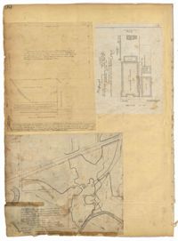
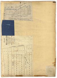
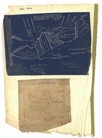
Page 100 of the City Engineer's Plat Book with four plats. Plat 1 features lots located near the intersection of Broad Street and Friend Street. Plat 2 shows lots and structures on Meeting Street. Plat 3 shows land located near the intersection of Drake Street and Cool Blow Street, including a stretch of the North Eastern Rail Road, a creek leading to the Cooper River, and some marshland. Plat 4 is affixed to the page so it folds in and out, and shows lots located near a stream, Pine Street, Alleyway Street, Norman Street, and Ashton Street.
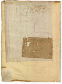
Page 128 of the City Engineer's Plat Book with one plat. The plat shows a city block between Meeting Street and Church Street, and between Cumberland Street and Market Street. A label reads "Champion Cotton Press Co. Lots," and another reads "Tudor Ice House."
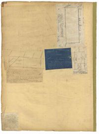
Page 150 of the City Engineer's Plat Book with five plats. Plat 1 shows lots located between President Street and the Ashley River, and between Spring Street and Mill Street. It also shows an "Ashley River Bridge" on Spring Street, and a lot labeled "Charleston and Savannah R.R." Plat 2 shows lots and structures located on the west side of Rutledge Avenue. Plat 3 features a lot located on the corner of St. Philips Street and Calhoun Street. Plat 4 shows lots located on the east side of Rutledge Avenue. Plat 5 shows lots and structures located on King Street, including labels reading "Upper Police Station" and "Cistern Underground."
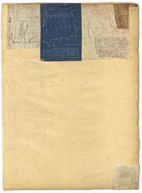
Page 153 of the City Engineer's Plat Book with three plats. Plat 1 shows lots located between Rutledge Street and Lynch Street, near where they intersect with Calhoun Street. Plat 2 shows lots located on and near the intersection of Rutledge Avenue and a private court. Plat 3 shows lots located between Smith Street and Ogier Street, near where they intersect and Vanderhorst Street.
Page 164 of the City Engineer's Plat Book with three plats. Plat 1 shows lots located between Meeting Street and Aiken Street, and between Cooper Street and Line Street. Plat 2 shows lots located on Felix Street. Plat 3 shows lots located on Grove Street, and shows a stream and a label reading "Frenchman's Hill."
Page 165 of the City Engineer's Plat Book with three plats. Plat 1 shows lots located near a "Public Road from and to Charleston." It also shows marsh land, a fishpond, and a garden. Plat 2 shows land located near the intersection of America Street and Brigade Street. Plat 3 shows lots located near the intersection of Meeting Street and Riker Street, including a stretch of land labeled "Low Ground."
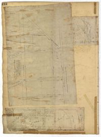
Page 99 of the City Engineer's Plat Book with four plats. Plat 1 shows land located near Meeting Street, between Williams Street and Semmes Street. Plat 1 also shows Nassau Street, Romney Street, some marshland, and New Market Creek. Plat 2 shows a lot with two structures located on Laurel Street. Plat 3 features lots located between Congress Street and Gadsden Street, near Pinckney Street. Plat 4 features lots located along Mount Street, between President Street and Payne Street.
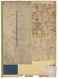
Page 97 of the City Engineer's Plat Book with three plats. Plat 1 shows a stretch of land extending from Cunnington Street to Columbus Street, with a projected rout for America Street. Plat 1 also shows Hampstead Mall, Meeting Street, several creeks, some city lands, and a stretch of King Street. Plat 2 shows land from near Line Street to Hudson Street, between King Street and Meeting Street. Plat 2 also features structures, including several freight depots. Plat 3 shows a lot labelled "Lands of Fourth Brigade," between Brigade Street and William Street.
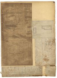
Page 212 of the City Engineer's Plat Book with three plats. Plat 1 shows lots located between Broad Street, Tradd Street, and Savage Street. Plat 2 shows lots and structures located near the intersection of Tradd Street and Chisolm Street, including wharves, a storehouse, a rice mill, an engine house, and a saw mill. Plat 3 shows lots, structures, and geographic features located between New Street and the Ashley River. Plat 3 also includes Tradd Street, Savage Street, Rutledge Street, Lynch Street, and a large stretch of marshland.
The front page of the City Engineer's Plat Book with two plats. The topmost plat shows a stretch of marshland located on the Ashley River. The bottom plat shows a stretch of land on the Cooper River.