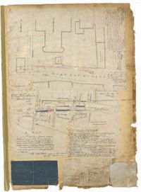
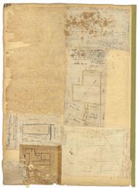
Page 1 of the City Engineer's Plat Book with four plats. Plat 1 shows the intersection of East Bay Street and Market Street, and labels reading "New Custom Ho.," "Old Flash," "Scale House," and "Market." Plat 2 shows a stretch of East Bay Street from the intersection with Guignard Street to Pritchard Street, including the bridge crossing over Canal Street. Plat 3 shows the intersection of Tradd Street and Greenhill Street. Plat 4 features Beaufain Street's intersections with St. Phillip Street and Archdale Street, and features a plot of land labelled "Normal School Yard."
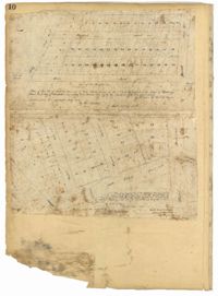
Page 10 of the City Engineer's Plat Book with two plats. Plat 1 shows plots located near Pointset Street and Grove Street between King Street and Russell Street. Plat 2 shows plots near Judith Street and Chapel Street, and includes "Beaufort's Court" and "Heyward's Court."
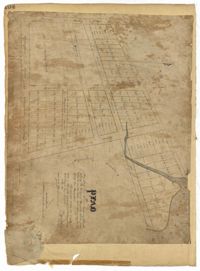
Page 104 of the City Engineer's Plat Book with one plat. The plat shows lots located between Moultrie Street and Cunnington Street. It also shows Lemon Street, Lee Street, Price Street, and Magnolia Street. It also shows a plat labelled "Artilery Society" and another plat labelled "Magnolia Cemetery."
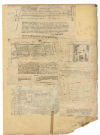
Page 11 of the City Engineer's Plat Book with five plats. Plat 1 shows a plot of land on the Charleston Harbor located near the intersection of East Bay Street and Queen Street. Plat 2 shows lots located between Conin Creek and King Street, and between Vanderhorst Street and "Manigault alias Boundary Street." Plat 3 shows plots and buildings located near the intersection of Liberty Street and St. Philip Street. Plat 4 features a plots, including one belonging to the "German Lutheran Church," located between King Street and Archdale Street.
Page 120 of the City Engineer's Plat Book with five plats, labelled two through six. Plat 2 shows lots and buildings located near Cumberland Street, between Church Street and Philadelphia Street. Plat 3 shows lots located near the intersection Pinckney Street and Anson Street. Plat 4 shows lots and structures located on Hasell Street. Plat 5 shows lots and buildings along East Bay Street. Plat 6 shows lots and structures located between wharf street and the Cooper River.
Page 124 of the City Engineer's Plat Book with one plat. The plat features several lots and structures located on and near King Street, with one labelled "Theatre Lot."
Page 13 of the City Engineer's Plat Book with five plats. Plat 1 features plots on East Bay Street between Tradd Street and Broad Street (which is labelled in the top-left corner), including several wharfs. Plat 2 shows lots located between Archdale Street and King Street, including a plot belonging to the "German Lutheran Church." Plat 3 features a plot of land located on King Street. Plat 4 shows plots located on State Street between Market Street and Amen Street. Plat 5 features "Potters Field Public Cemetery," located near President Street and Congress Street.
Page 141 of the City Engineer's Plat Book with four plats. Plat 1 features a lot and structures located between Lynch Steet and the Ashley River, near Broad Street. It also shows Comings Creek, a pond, and a lot labelled "Clark & Steinmeyer." Plat 2 shows lots and structures located near the intersection of College Street and Calhoun Street. Plat 3 shows a lot and structures in "the City of Charleston in Ward No. 9." Plat 4 shows lots on and near Society Street, between Meeting Street and King Street.
Page 148 of the City Engineer's Plat Book with two plats. Plat 1 shows lots and structures located on and near Calhoun Street, between Washington Street and the Cooper River. Plat two shows "Lots in the Village of Rikersville," including 21 acres of marshland, a canal, and a pond.
Page 149 of the City Engineer's Plat Book with one plat. The plat shows lots located between Meeting Street and King Street, including a stretch of railroad.
Page 15 of the City Engineer's Plat Book with three plats. Plat 1 features plots located between Rutledge Street and Smith Street, near the intersections with Queen Street. Plat 2 features a lot on the corner of Tradd Street and Savage Street. Plat 3 shows the intersection of Calhoun Street and Rutledge Avenue (also labelled as Rutledge Street) with proposed changes.
Page 158 of the City Engineer's Plat Book with four plats. Plat 1 shows lots located on South Street, near where it intersects with Hanover Street. Plat 2 shows lots located on and near Mill Street, near its intersections with Lucas Street and President Street, and shows a building labelled "Dead House" and a creek labeled as "leading to canal." Plat 3 shows lots and structures located on East Bay Street. Plat 4 shows South Bay Street and its intersections with Legare Street and King Street.
Page 159 of the City Engineer's Plat Book with five plats. Plat 1 shows lots and structures located on East Bay Street, between Hasell Street and Cumberland Street. Plat 2 features a lot located on King Street, between Hudson Street and Tobacco Street. Plat 3 shows lots located between State Street and East Bay Street, located near their intersections with Market Street. Plat 4 shows lots located along "Horlbecks Alley," between King Street and Meeting Street. Plat 5 shows lots located on Short Street, between Mazyck Street and Franklin Street.
Page 160 of the City Engineer's Plat Book with four plats. Plat 1 shows a stretch of Mazyck Street, near its intersections with Queen Street and Short Street. Plat 2 shows lots and structures located on and near Reid Street, between Drake Street and Bay Street. Plat 4 shows lots and structures located between Nassau Street and Meeting Street, and between Stewart Street and Johnson Street.
Page 162 of the City Engineer's Plat Book with three plats. Plat 1 shows land located near Payne Street with several streams. Plat 2 shows lots located in the Village of Hampstead, located near America Street. The plat also shows marshland and streams. Plat 3 has numerous tears and holes. Plat 4 shows lots and structures located between Meeting Street and Lynch Street.
Page 163 of the City Engineer's Plat Book with two plats. Plat 1 shows lots and structures located on Friend Street, near its intersections with Queen Street, Broad Street, and an unlabeled street. Plat 2 shows lots located on King Street, near where it intersects with Broad Street.
Page 171 of the City Engineer's Plat Book with three plats. Plat 1 shows lots located on and near the intersection of Meeting Street and Mt. Pleasant Street. Plat 2 shows lots located along King Street, near its intersection with Mt. Pleasant Street. Plat 3 shows the intersection of Calhoun Street and Smith Street.
Page 29 of the City Engineer's Plat Book with three plats. Plat 1 shows lots and structures located near Calhoun Street, Rutledge Street, Lynch Street, Gadsden Street, Lucas Street, and Bennett Street, including a lot labelled "Public Square," a creek, and a building labelled "Saw Mill." Plat 2 shows land located near the intersection of West Bay Street and a body of water labelled "Mill Pond." Plat 3 shows land located near the Ashley River channel and a road labelled "Causeway Leading to Rice Mill."
Page 28 of the City Engineer's Plat Book with three plats. Plat 1 shows lots located near Calhoun Street, Bull Street, South Street, Ashley Street, Rutledge Street Lynch Street, and Bennett Street. Plat 1 also shows lots labelled "The Mall," and Lots Belonging to Sundry Persons. Plat 2 shows lots and buildings located near the intersection of Calhoun Street and Lucas Street, including lots labelled "Mansion Lot" and "Left for a Public Square." Plat 3 shows lots and buildings located near Bee Street, between Ashley Street and Rutledge Street.
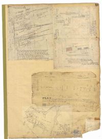
Page 27 of the City Engineer's Plat Book with five plats. Plat 1 shows lots located on Broad Street, between the intersections with East Bay Street and State Street. Plat 2 shows lots on Chapel Street. Plat 3 shows lots near Savage Street and Tradd Street. Plat 4 shows lots on Savage Street. Plat 5 shows lots near the intersection of Broad Street and East Bay Street.