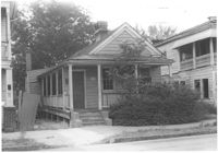
House (freedman's cottage) on site affected by the construction of the Crosstown. Address: 149 President Street. Surveyor notations on back of photo: "Dkt.: 10.524. Property owner: Mamie B. Motte. Tract: 32. Station: 67+90 Rt. Date: Oct. 13, 1964. In R/W - Bought." [See collection description for explanation of surveyor notations.]
House (rear view) on site affected by the construction of the Crosstown. Address: 22 Wescott Street. Surveyor notations on back of photo: "Dkt.: 10.524. Property owner: Ida J. Gantt. Tract: 10. Station: 61+20 Lt. Date: Oct. 13, 1964. Portion in R/W to be removed by property owner." [See collection description for explanation of surveyor notations.]
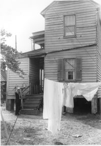
House (rear view) on site affected by the construction of the Crosstown. Address: 11 Presidents Place. Surveyor notations on back of photo: "Dkt.: 10.524. Property owner: Lucille Smalls. Tract: 9. Station: 63+10 Rt. Date: Oct. 13, 1964. In R/W - Bought." [See collection description for explanation of surveyor notations.]
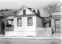
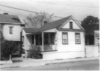
House on site affected by the construction of the Crosstown. Address: 162 Cannon Street. Surveyor notations on back of photo: "Dkt.: 10.524. Property owner: Willie Williams. Tract: 4. Station: 61+15 Rt. Date: Oct. 13, 1964. In R/W - Bought." [See collection description for explanation of surveyor notations.]
House on site affected by the construction of the Crosstown. Address: 162 Cannon Street. Surveyor notations on back of photo: "Dkt.: 10.524. Property owner: Willie Williams. Tract: 4. Station: 61+15 Rt. Date: Oct. 13, 1964. In R/W - Bought." [See collection description for explanation of surveyor notations.]
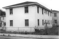
Rear view of apartment building on site affected by the construction of the Crosstown. Address: 123 Bogard Street. Surveyor notations on back of photo: "Dkt.: 10.524. Property owner: Henry W. Smith. Tract: 48. Station: 73+10 CL. Date: Oct. 14, 1964. In R/W - Bought." [See collection description for explanation of surveyor notations.]
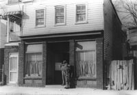
House on site affected by the construction of the Crosstown. Address: 158 Line Street. First story appears to be a store (or office) front. Signs for W.L. Metz, Jr. and H.L. Davis in window. Surveyor notations on back of photo: "Dkt.: 10.524. Property owner: William A. Williams. Tract: 102. Station: 83+70 CL. Date: Dec. 1, 1964. In R/W - Bought. [See collection description for explanation of surveyor notations.]
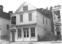
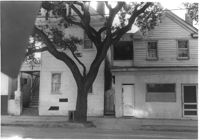
House on site affected by the construction of the Crosstown. Address: 182 Spring Street. First floor appears to have been a store. Surveyor notations on back of photo: "Dkt.: 10.524. Property owner: A.J.R. Kornahrens. Tract: 27. Station: 65+75 Rt. Date: Oct. 13, 1964. In R/W - Bought." [See collection description for explanation of surveyor notations.]
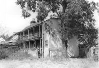
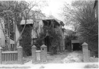
House (and neighboring house) on site affected by the construction of the Crosstown. Address: 495 Rutledge Avenue. Surveyor notations on back of photo: "Dkt.: 10.524. Property owner: Elise C. Goldberg, et al. Tract: 105. Station: 84+15 Rt. Date: Dec. 1, 1964. In R/W - Bought." [See collection description for explanation of surveyor notations.]
House and driveway on site affected by the construction of the Crosstown. Address: 6 Norman Street. Surveyor notations on back of photo: "Dkt.: 10.524. Property owner: Julia Williams Glover. Tract: 22. Station: 67+00 Lt. Date: Oct. 13, 1964. In R/W - Bought." [See collection description for explanation of surveyor notations.]
Limit your search
SCDOT Photographs: Properties in the Right-of-Way✖[remove]381