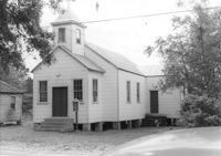
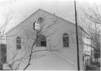
Enah Chapel Church on site affected by the construction of Interstate 26 (I-26). Surveyor notations on back of photo: "Dkt.: 10.480. Property owner: Enoch Methodist Church. Tract: 36. Station: 5507+80 Lt. Date: May 2, 1961. In R/W - Bought." [See collection description for explanation of surveyor notations.]
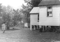
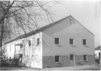
Enah Chapel (side view, rear) and structure that appears to be an outhouse, on site affected by the construction of Interstate 26 (I-26). Surveyor notations on back of photo: "Dkt.: 10.480. Property owner: Enoch Methodist Church. Tract: 36. Station: 5508+20 Lt. Date: May 2, 1961. In R/W - Bought." [See collection description for explanation of surveyor notations.]
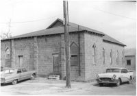
Mount Pisgah Baptist Church (rear view, corner) on site affected by the construction of Interstate 26 (I-26). Address: northwest corner of C and E Street. Surveyor notations on back of photo: "Dkt.: 10.517. Property owner: Mt. Pisgah Baptist Church. Tract: 21. Station: 5946+40 CL - Line 6. Date: February 21, 1963. In R/W - Bought." [See collection description for explanation of surveyor notations.]
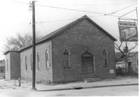
Mount Pisgah Baptist Church on site affected by the construction of Interstate 26 (I-26). Address: northwest corner of C and E Street. Sign for Washington Grocery in foreground at right (appears to be across the street). Surveyor notations on back of photo: "Dkt.: 10.517. Property owner: Mt. Pisgah Baptist Church. Tract: 21. Station: 5946+40 CL - Line 6. Date: February 21, 1963. In R/W - Bought." [See collection description for explanation of surveyor notations.]
Building -- Church of God of Prophecy -- on site affected by the construction of Interstate 26 (I-26). Address: 93 Lee Street. Surveyor notations on back of photo: "Dkt.: 10.517. Property owner: Church of God of Prophecy. Tract: 55. Station: 5955+15 Lt. Main Line. 34+00 Lt. & Rt. Route 17. Date: February 21, 1963. In R/W - Bought." [See collection description for explanation of surveyor notations.]
Building (rear view, corner) -- Church of God of Prophecy -- on site affected by the construction of Interstate 26 (I-26). Address: 93 Lee Street. Surveyor notations on back of photo: "Dkt.: 10.517. Property owner: Church of God of Prophecy. Tract: 55. Station: 5955+15 Lt. Main Line. 34+00 Lt. & Rt. Route 17. Date: February 21, 1963. In R/W - Bought." [See collection description for explanation of surveyor notations.]
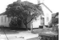
Francis Brown Methodist Church, on site affected by the construction of Interstate 26 (I-26). [2202 Joppa.] Surveyor notations on back of photo: "Dkt.: 10.490. Property owner: Francis Brown Meth. Church. Tract: 51. Station: 5799+50 Lt. Line 'F'. Date: September 12, 1962. Proximity to rear." [See collection description for explanation of surveyor notations.]
Francis Brown Methodist Church (rear view), on site affected by the construction of Interstate 26 (I-26). [2202 Joppa.] Surveyor notations on back of photo: "Dkt.: 10.490. Property owner: Francis Brown Meth. Church. Tract: 51. Station: 5799+50 Lt. Line 'F'. Date: September 12, 1962. Proximity to rear." [See collection description for explanation of surveyor notations.]
Right of way--South Carolina--Charleston County, Highway planning--South Carolina--Charleston County, Vernacular architecture--South Carolina--Charleston County, Lost architecture--South Carolina--Charleston County, Church buildings--South Carolina--Charleston County✖[remove]8
Charleston County (S.C.)--Buildings, structures, etc.✖[remove]8