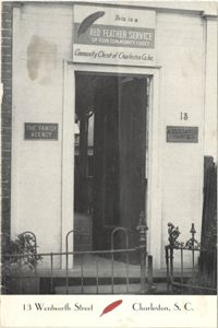
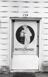
A photograph of the doorway leading into 13 Wentworth Street printed on a publication for the Red Feather Service of the Community Chest of Charleston Co. Inc.
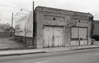
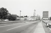
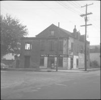
Black-and-white photograph of 131 Market Street (Boswick's Auto Service), corner view of building (northeast elevation). Now the site of the entrance to a parking lot. Billboard for Historic Savannah posted on side of building.
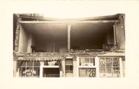
Photograph of the Sing Lee Laundry (133 King Street) after the tornadoes of September 29, 1938, showing the damage done to the building. Signs for the Robbins Bros. Circus (on Sept. 26) are posted in the windows.
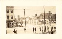
Black-and-white photograph of the view east on Market Street from near the intersection of Archdale Street. Market Hall in the distance. Goodyear building at left; 40 Archdale Street at right.
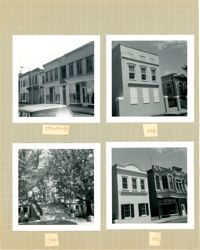
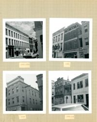
Four B&W photographs of buildings on the east side of King Street: Top left (178-184): 178 King Street (W.K. Prause Co.), 180 King Street, 182 King Street, and 184 King Street; Top right: 174 King Street; Bottom left: 164 King Street (Charleston Library Society) [labeled 168 on album page]; Bottom right (160-162): 160 King Street and 162 King Street.
Four B&W photographs of buildings on the west side of King Street: Top left (181-183): 181 King Street (Jack Patla Antiques) and 183 King Street (The Art Shop); Top right (175-179): 175 King Street, 177 King Street, and 179 King Street (Fralix & Sons); Bottom left (169-173): 169 King Street (R.M. McGillivray's) and 171-173 King Street; Bottom right (165-169); 165 King Street and 169 King Street (R.M. McGillivray's).
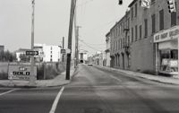
View looking east on Market Street from the junction of King Street and Market, showing the parking lot where Belk Department Store once was (left) and 220 King Street (Blue Knight Gallery) (right) down to Market Hall (distance). Meeting Street elevation of the Arnold-Hornik Building (112 North Market) also in distance. "Sold" sign on fence surrounding the lot, which is now the site of Charleston Place / Charleston Center.
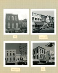
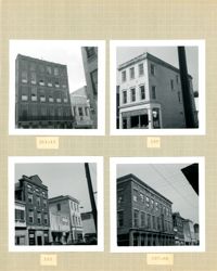
Four B&W photographs of buildings on the east side of King Street: Top left (188-200): 188 King Street (Installment Finance Co. Loans), 190 King Street, and 192-200 King Street (Hoffman House); Top right (188-190): Edge of 188 King Street (Installment Finance Co. Loans) and 190 King Street (Home Appliances and Service Co.); Bottom left: 188 King Street (Installment Finance Co.); Bottom right (184-186): 184 King Street (Dinty Moore's) and 186 King Street.
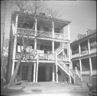
In this one-page typed bulletin, Green discusses the ownership and occupancy histories of 42 Anson Street; 44 Anson Street; 46 Anson Street; 48 Anson Street; and 50 Anson Street. Also focuses on Martin Dowd's properties in Charleston, including 53 Tradd Street.
Black-and-white photograph of Market Hall (188 Meeting Street) and the view east on South Market Street showing the Market sheds. Corner of North Market Street also in view.
Black-and-white photograph of the view east on Hasell Street from the C. B. Prentiss & Co. Customer Parking Lot and 95 Hasell Street (St. Mary’s Roman Catholic Church). 87 Hasell and 85 Hasell also in view at left.
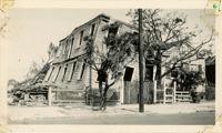
Photograph 19 King Street [Thomas Lamboll House] after the tornadoes of September 29, 1938, showing the damage done to the house. King Street elevation.
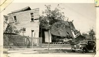
Photograph of Lamboll Street elevation of 19 King Street [Thomas Lamboll House] after the tornadoes of September 29, 1938, showing the damage done to the piazzas and roof. Men are standing on the roof.
Black-and-white photograph of 190-194 Meeting Street, street (west) elevation. 190 Meeting Street [112 North Market] is located at the northeast corner of Meeting and Market Streets. 190 Meeting Street (Hornik Dry Goods & Ready-to-Wear / M. Hornik & Co.) and 194 Meeting Street formerly was the Regular Veterans Association Post 479 building. Front of Market Hall at left.
Four B&W photographs of buildings on the west side of King Street, including 213 King and 215 King, demolished for the construction of Majestic Square: Top left (211-215): 211-213 King (Palmetto Hotel) and 215 King Street (Stephan's); Top right: 197 King Street; Bottom left 193-197: 193 King Street (Colonial Antique Shop), 195 King Street, and 197 King Street; Bottom right (191-197): 191 King Street (Birlant Antiques), 193 King Street, 195 King Street, 197 King Street.
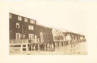
Photograph of the United Fruit Company dock after the September 29, 1938, tornadoes. (Based on Sanborn Maps, the dock was located at the foot of Laurens Street, Southern Railway Pier 2.)
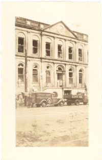
Photograph of City Hall after the tornadoes of September 29, 1938, showing the damage done to the building. Two trucks, including an Automatic Grocery truck, are parked in front of building. Onlookers are on the sidewalk in front of building; men stand at doorways and windows.
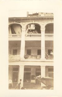
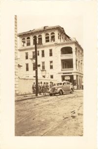
Photograph of the Timrod Hotel [ca. 101 Meeting Street], after the tornadoes of September 29, 1938, showing the damage done to the building. East elevation. Men are sitting on the second story piazza ledge. Men stand on the sidewalk by a truck that is carrying debris. [Note: The hotel was later demolished in the 1960s.]
Looking northwest on Market Street from the U.S. Custom House on East Bay Street, after the tornadoes of September 29, 1938, showing damaged and ruined Market Sheds. Also shows the damaged buildings on North Market Street. Onlookers and cars are in the street. Partial view of ca. 225 East Bay Street (now gone) is on the left.
Photograph of a house on Fishburne Street demolished by the tornado of 1938. Neighboring house in view at left. (Both houses would have been on the north side of the 200 block of Fishburne Street.) Handwritten on back of photo: "2nd tornado on Fishburne Street near President Street. Demolished about 60 houses here. This 2nd tornado damage about $6,000,000. 300 houses condemned. Sept. 29, '38."
Photograph of the wreckage of the Calvary Baptist Church, an African-American church demolished by the tornado of September 29, 1938. Located at the corner of Sumter Street and Ashley Avenue; address may have been 387 Sumter Street. Handwritten on back of photo: "Old Negro church on Sumter Street, corner of Ashley Avenue. This was done by second tornado that hit 2 miles from the other one. Sept. 29, 1938."
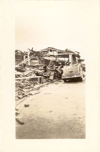
Photograph of the ruins of a building on King Street after the tornadoes of September 29, 1938. Shows the debris of a completely demolished structure and the damaged roof of the neighboring building. Based on newspaper accounts, this is probably the site of the Rectory of the Church of the Sacred Heart at King and Huger Streets. Three men stand on the sidewalk facing the debris; other men are standing on a pile of debris.
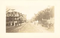
Looking east on Market Street after the tornadoes of September 29, 1938, showing the Market Sheds in ruins. A damaged car is parked along side of the debris. The Old Church of the Redeemer can be seen in the background.
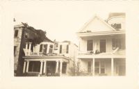
Photograph of 38 South Battery and 40 South Battery [Frederick Heinz Houses] and a portion of 42 South Battery, after the tornadoes of September 29, 1938, showing the damage done to the houses.
Photograph of the Timrod Hotel [ca. 101 Meeting Street], after the tornadoes of September 29, 1938, showing the damage done to the building. View of the hotel looking north on Meeting Street (southeast elevation). Infantry patrolmen stand on sidewalk by a car. Signage for Byars Drug Store is on the south elevation. [Note: The hotel was later demolished in the 1960s.]
Photograph of Broad Street, looking east at the 60 block, showing the scene on the street after the tornadoes of September 29, 1938. The Daniel Ravenel House (68 Broad Street), the Confederate Home, and the People's Building can be seen at the right; the Old Exchange Building is visible in the background. Onlookers, cars, and a person riding a bicycle are on the street.
Photograph showing several dwellings in Fiddlers Green damaged or destroyed by the tornado of 1938. Handwritten on back of photo: "1st tornado hit Fiddlers Green, Negro section by Ashley Bridge, Hilly Street [should be Lilly Street], Sept. 29, '38."
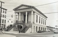
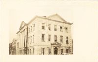
Photograph of the Charleston County Courthouse after the tornadoes of September 29, 1938, showing the damage done to the building. View of the corner elevation (Meeting Street and Broad Street). People who are standing inside the building at the second and third story windows can be seen. To the left of the Courthouse, the Hebrew Orphanage (88 Broad Street) is also in view.