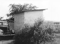
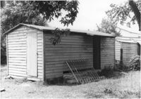
Sheds and old car, on site affected by the construction of Interstate 26 (I-26). [Building address number 131.] Surveyor notations on back of photo: "Dkt.: 10.480. Property owner: Minnie L. Geiger. Tract: 277. Station: 5726+80 Rt. (Line C). Date: May 31, 1961. In R/W - Bought." [See collection description for explanation of surveyor notations.]
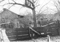
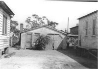
Sheds (rear view) and lot on site affected by the construction of the Crosstown. Address: corner of Lanier Court and Hanover Street. Surveyor notations on back of photo: "Dkt.: 10.518. Property owner: Bessie Rosen. Tract: 41. Station: 44+40 Rt. N.B. lane Route 17. Date: Mar. 6, 1963." [See collection description for explanation of surveyor notations.]
Shed or garage on site affected by the construction of Interstate 26 (I-26). Address: 516½ Meeting Street. Surveyor notations on back of photo: "Dkt.: 10.517. Property owner: Helen Phillips Brown, et al. Tract: 60-A. Station: 5960±40 Lt. - Line 6. Date: March 5, 1963. In R/W - Bought." [See collection description for explanation of surveyor notations.]
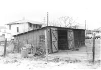
Shed or garage on site affected by the construction of Interstate 26 (I-26). Address: 85 Sheppard Street. Surveyor notations on back of photo: "Dkt.: 10.517. Property owner: Douglas E. Holmes. Tract: 86. Station: 26+40 Lt. Northbound Lane Route 17. Date: March 5, 1963. In R/W - Bought." [See collection description for explanation of surveyor notations.]
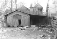
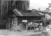
Shed/outbuilding on site affected by the construction of the Crosstown. Address: 121 America Street. Surveyor notations on back of photo: "Dkt.: 10.518. Property owner: Vallie Talbert. Tract: 58. Station: 48+87 Lt. N.B. lane Route 17. Date: Mar. 7, 1963. All in R/W." [See collection description for explanation of surveyor notations.]
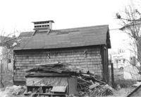
Shed or garage associated with Francis Brown Methodist Church, on site affected by the construction of Interstate 26 (I-26). [2202 Joppa.] Surveyor notations on back of photo: "Dkt.: 10.490. Property owner: Francis Brown Meth. Church. Tract: 52. Station: 5799+80 Lt. Line 'F'. Date: September 12, 1962. To be cut off at R/W by SCHD [SC Highway Department]." [See collection description for explanation of surveyor notations.]
Shed on site affected by the construction of Interstate 26 (I-26). Surveyor notations on back of photo: "Dkt.: 10.490. Property owner: Leah D. Governor. Tract: 58. Station: 5800+60 Rt. Line 'G'. Date: September 12, 1962. In R/W - Bought." [See collection description for explanation of surveyor notations.]
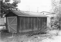
Shed on site affected by the construction of Interstate 26 (I-26). Address: 2136 Montford Avenue. Surveyor notations on back of photo: "Dkt.: 10.490. Property owner: Werner R. Mohrmann. Tract: 170. Station: 5884 ±20 Rt. Date: August 29, 1962. In R/W - Bought." [See collection description for explanation of surveyor notations.]
Shed on site affected by the construction of Interstate 26 (I-26). Address: 2130 Montford Avenue. Surveyor notations on back of photo: "Dkt.: 10.490. Property owner: Rosa Lee Knight. Tract: 173. Station: 5884+00 Lt. Date: May 15, 1962. In R/W - Bought." [See collection description for explanation of surveyor notations.]
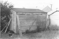
Shed on site affected by the construction of Interstate 26 (I-26). Address: 2128 Montford Avenue. Surveyor notations on back of photo: "Dkt.: 10.490. Property owner: Chas. W. Jenkins, Jr. [Charles W. Jenkins, Jr.]. Tract: 174. Station: 50' Lt. Sta. 5884+00. Date: May 15, 1962. In R/W - Bought." [See collection description for explanation of surveyor notations.]
Right of way--South Carolina--Charleston County, Highway planning--South Carolina--Charleston County, Vernacular architecture--South Carolina--Charleston County, Lost architecture--South Carolina--Charleston County, Sheds--South Carolina--Charleston County, Outbuildings--South Carolina--Charleston County✖[remove]27
Charleston County (S.C.)--Buildings, structures, etc.✖[remove]27